Q. Give us an example of how you’ve used satellites to deal with volcanoes.
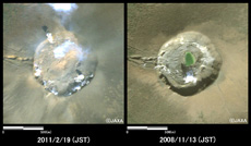
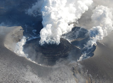
A crater observed by DAICHI before an eruption (right) and after (left). The post-eruption image shows that lava remains in the crater.
![]()
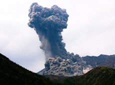
A recent example I can give you is the eruption of Mt. Shinmoe last year. When it erupted in January 2011, the summit crater spewed out lava. We asked JAXA to make precise observations using DAICHI, so we could get details on how the lava was spreading inside the crater. Based on DAICHI’s imagery, we were able to issue an eruption warning with clear, specific information: “The lava dome has expanded to a diameter of around 500 meters.”
The JMA issues Volcanic Alert Levels along with eruption warnings. There are five levels, based on the nature of the volcanic activity, the level of danger should there be an eruption, and any required disaster-prevention measures. We’ve named the levels in a way that’s very easy to understand: “Normal,” “Do not approach the crater,” “Do not approach the volcano,” “Prepare to evacuate,” and “Evacuate.” In the case of Mt. Shinmoe, DAICHI provided crucial data that allowed us to make the decision to issue the eruption warning and Volcanic Alert Level.
DAICHI’s observational data also helps detect crustal deformation caused by an eruption. With interferometric images from DAICHI’s synthetic aperture radar (SAR), we could see the swelling of the crust prior to the eruption – due to an underground accumulation of magma northwest of Mt. Shinmoe – as well as the crust’s contraction afterward. Even though DAICHI is no longer operating, we know that the crustal deformation around Mt. Shinmoe continued after the last eruption in September 2011, and finally calmed down in December 2011.
Mt. Shinmoe still has lava in the crater, so there’s a continuing risk of a sudden eruption, and we are continuing to monitor the volcanic activity there. I’m anxiously looking forward to the safe launch of the next Advanced Land Observing Satellite (ALOS-2), so that we can continue volcanic observations from space.
Q. How many active volcanoes are there in Japan now? Is the JMA monitoring all of them?
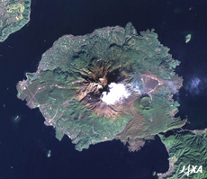
Sakurajima crater, photographed from a helicopter of the 72nd Kanoya Air Detachment, Marine Self-Defense Force. Japan has 110 active volcanoes. (courtesy: JMA)
The JMA defines volcanoes as active if they have erupted in the past 10,000 years, or if they are currently undergoing fumarolic activity (i.e. emitting smoke). Japan has 110 of them. That makes us one of the most volcanic countries on Earth, since there are only about 1,500 active volcanoes worldwide. But Japan has many kinds of active volcanoes, from those with very sustained activity causing frequent eruptions, such as Sakurajima in Kagoshima, to ones that have not erupted in a very long time. There are 47 particularly active volcanoes that have erupted regularly in recent years or have experienced increased volcanic activity in the past century. We monitor these continuously with seismographs, atmospheric vibration sensors, GPS, tiltmeters, monitoring cameras, etc.
Speaking of which, there’s been talk lately about whether Mt. Fuji is going to erupt, and it is in fact one of the 47 volcanoes under continuous monitoring. Right now there is no evidence from the observational data that its volcanic activity is changing. Since we haven’t seen any signs of an impending eruption, its Volcanic Alert Level is currently 1, or Normal.
Q. Can we predict eruptions by monitoring volcanoes?
When there is increased seismic activity and changes observed by tiltmeters around a volcano, and we determine that there is a high likelihood of an eruption, we issue an eruption warning. But we also know that some volcanoes erupt suddenly, without any noticeable changes beforehand. So it’s difficult to make a precise prediction of when an eruption will occur. For example, just before Mt. Asama erupted in 2009, we issued a warning that an eruption was imminent, but it didn’t happen until about 13 hours later.
There are two ways to put out an eruption warning. One is a “predictive” warning that you put out before the eruption, while the other is a “fact-based” warning that goes out after the eruptive activity starts. I believe that information from satellites will be used a lot in fact-based warnings, because it is so important to accurately understand the nature of an eruption, so that we can respond in the safest and most effective way.
Q. What are the advantages of using satellites to observe volcanoes?
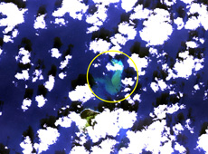
Image provided by DAICHI of an underwater volcanic eruption near South Iwo Jima, one of the Ogasawara Islands. The white objects are clouds and the yellow circle shows water discoloration.
![]()
DAICHI’s synthetic aperture radar had the advantage of being able to make observations in any weather, day or night. It allowed us to see what was going on inside a crater even if it was blowing out a lot of smoke, because radar goes right through clouds and smoke. And it also gave us crisp images of lava around craters, where a regular optical camera would see only smoke.
And while ground-based sensors can give us pinpoint measurements, satellites have the advantage of being able to cover a wide area in one pass. It allows us to understand events that cover many square kilometers, such as pyroclastic flow, ejecta, smoke and changes to the terrain. Also, in the vicinity of volcanoes there are often openings in the Earth’s crust called fumaroles, which emit very hot gases. Some fumaroles are in mountainous areas with no road access, so they’re hard to keep track of. But with a satellite that’s no problem at all – we can observe these hard-to-reach spots from above.
I mentioned earlier that of the 110 active volcanoes in Japan, only 47 are under constant monitoring. But a satellite allows us to monitor all 110 volcanoes all the time. It’s very important to know what’s happening with volcanoes when they aren’t active. Even if there are no eruptive phenomena occurring on the surface, there may be magma slowly accumulating beneath the surface, swelling the ground in the volcano’s vicinity. Because satellite observation lets us see crustal deformation over a wide area, satellites play an important role in observing volcanic activity even when everything seems normal.
Another thing we cannot forget is underwater volcanoes. There are many of them in the seas around Japan. When one becomes active, the color of the water on the ocean’s surface changes. Until now we haven’t been able to find this water discoloration without taking a helicopter over the site of an underwater volcano, but a satellite would let us monitor a broad area of ocean all at once. So I think we’ll be using satellites to detect water discoloration, too.
Q. Is old observational data from DAICHI still being used?
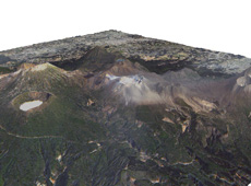
A three-dimensional image of an eruption of Mt. Shinmoe, based on data from DAICHI. The white and light gray areas on the mountain’s slopes show where ash has fallen.
![]()
Yes. We were just talking about fumaroles deep in the mountains. If they release only a little bit of volcanic gas, the emissions may go overlooked. That’s why we use DAICHI’s data archives to see if there was any volcanic activity we didn’t notice when our research teams climbed those volcanoes in the past.
Q. What obstacles do you think satellite-based volcanic observation needs to overcome?
Improving real-time observations. Ground-based instruments such as seismographs and tiltmeters show us what’s happening in a volcano in real time, but satellites are different. If there is no satellite passing over an erupting volcano, we can’t get measurements right away. Luckily, when Mt. Shinmoe erupted, we were able to get emergency observations from DAICHI in near-real time. This was possible because the JMA and JAXA already had a cooperative framework. So I think that if we build the right framework, we can ensure that we get a certain amount of real-time observation during a disaster.
Q. Are you happy with the state of Japan’s international cooperation with regards to disaster mitigation?
We use international observational data in our research to better understand volcanic activity, but currently we only issue eruption warnings and forecasts for volcanoes in Japan. I do think international cooperation is vital in responding to volcanic eruptions and disasters, especially since Japan is situated on the Ring of Fire around the Pacific Ocean, where most of the world’s active volcanoes are located.
One worldwide problem is that ash spewed from an active volcano can have a serious effect on aircraft engines. That’s why Volcanic Ash Advisory Centers (VAAC) have been set up at nine locations around the world. These centers issue Volcanic Ash Advisories to airlines and others who may be affected, with status reports on volcanic ash and dispersion forecasts along air routes. The JMA operates the Tokyo VAAC, which covers East Asia and the Northwest Pacific region. This region has many particularly active volcanoes, in places such as the Kamchatka Peninsula and the Philippines, in addition to Japan.
Q. What do you expect DAICHI’s successor to accomplish?
Right now we study ejecta from volcanic eruptions through overhead helicopter observations and ground-based monitoring. If the satellite imagery of DAICHI’s successor has higher resolution, we may be able, for example, to track the gas and rock ejected by a volcano far more precisely. Also, if the new satellite can make high-precision observations of crustal deformation, we hope to be able to predict where large amounts of volcanic ash from an eruption will fall.
But what everyone wants, of course, is for us to quickly release accurate information. We laid the foundations for satellite observation of volcanoes with DAICHI, so I think what we need to investigate next is how to improve observational precision by using satellites in combination with ground-based equipment.
Then, as far as releasing information quickly, I would really like to see us use satellites for continuous observation. Observing crustal deformation is important for predicting eruptions, so I’d like to work with JAXA to keep providing information that is directly relevant to disaster mitigation.
Senior Coordinator for Volcanic Affairs, Volcanological Division, Seismological and Volcanological Department, Japan Meteorological Agency
Mr. Funasaki graduated from Meteorological College in 1981. He conducted volcanic observations of the eruptions on Izu Oshima in 1986 and of Mt. Unzen in 1991. He has worked at the Fukuoka District Meteorological Observatory, the Matsushiro Seismological Observatory, and the Sapporo District Meteorological Observatory, before being assigned to his current post in April 2011.
Tracking Earthquakes by Monitoring Crustal Deformation
Using Satellites to Study Volcanic Activity
Using Satellites to Help Local Communities
A New Satellite to Battle Large-Scale Natural Disasters