Q. What action did you take when the Great East Japan Earthquake struck last year?
![]()
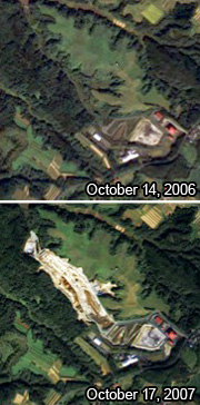
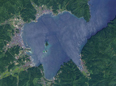
The area around Rikuzentakada city, Iwate prefecture before (upper image) and after (lower image) the Great East Japan Earthquake, as observed by DAICHI. The yellow circle shows where a pine grove that stretched for 2 km east to west was completely washed away by the tsunami. (courtesy: JAXA/ Yokoyama Geo-Spatial Information Laboratory Co., Ltd.)
![]()
Immediately after the earthquake, we consulted with JAXA and quickly started processing and analyzing DAICHI satellite imagery to get an understanding of the damage on the coast of Iwate, Miyagi and Fukushima prefectures, where the tsunami damage was greatest. We then made 1/30,000 scale images of the entire coastline available to the prefectures’ emergency response headquarters, municipalities, the Self-Defense Forces and the national government’s local agencies. Although the image of the Iwate coastline alone was seven meters long, I personally delivered it to the agencies that needed it. That was on March 16, five days after the quake. It took about three weeks for the Geospatial Information Authority to start releasing new aerial photographs, so these pre-quake DAICHI images were all we had.
Keep in mind, some of the images we provided were from before the disaster. Since I had already started applying DAICHI satellite imagery for local uses, we had these images available as well.
Q. How exactly were the images you provided put to use?
The pre- and post-quake images we provided were put up at the prefectural office and the military’s emergency response headquarters. All across the damaged area, many buildings were destroyed by the tsunami; electricity, telecommunications networks and transportation links were cut off; and cars couldn’t move because of gasoline shortages. It was extremely challenging trying to understand the nature of the damage and to send aid to remote places such as the tips of peninsulas and islands. Under these trying circumstances, the DAICHI images helped enormously in allowing us to understand the nature of the damage across the whole area we had to cover.
Q. Did you already have connections with municipalities before you started sending them images?
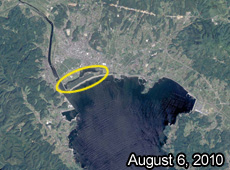
Yamada Bay, Iwate prefecture before the earthquake, as observed by DAICHI. (Photo taken on September 10, 2006.) (courtesy: JAXA/ Yokoyama Geo-Spatial Information Laboratory Co., Ltd.)
![]()
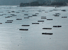
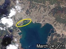
Yamada Bay, Iwate prefecture, photographed in December 2012. New cultivation rafts are visible. (courtesy: Ryuzo Yokoyama)
We’d done a lot of work for local officials in the Tohoku District through our local application projects with DAICHI imagery, so I had a network. My intent was to popularize the use of satellite data through joint research and other work with them. Because of these relationships, I had local officials coming directly to me and asking, “Do you have any satellite images?”
For example, one of them was the municipal government in Yamada-cho, in Iwate. A few months after the tsunami, they requested a pre-quake DAICHI image of Yamada Bay. They cultivate a lot of seafood – oysters, scallops and wakame seaweed – and they had 4,000 cultivation rafts in Yamada Bay. All these rafts were washed away by the tsunami. If they couldn’t restart the cultivation, then all the people in the fishing industry would lose their incomes. So based on the pre-disaster images, which showed the position of the rafts, they were able to restore Yamada Bay. Now, a year after the earthquake, they’ve brought back around 70% of the rafts.
Q. What problems do you think need to be solved regarding the use of satellites in disaster response?
A crucial part of effective disaster response is getting information out quickly and making sure it gets to the people who need it. That’s why it’s important in normal times to partner with local communities and build a network. In the town of Yamada-cho, which I was just talking about, some people had the foresight to make good use of satellite data, but there certainly weren’t many others who did. I feel that we still need to do more to popularize the use of satellite data by local communities.
Q. In what ways do you hope satellite data will be used?
Every day people see images from Himawari, the weather satellite, during the weather forecast on TV. The average viewer sees the image and thinks something like, “I guess I should bring an umbrella today because it’s cloudy and it might rain.” The image lets us imagine approximately what the weather will be like. These images from Himawari are now firmly rooted in our daily lives.
I’d like to popularize images from Earth observation satellites such as DAICHI, so that they are used on a frequent, daily basis, like images from Himawari. I imagine people in sectors such as agriculture, forestry and fishing studying Earth observation satellite imagery as they would a weather map, getting information that helps them with their work. But to do that we need effective techniques for using these images.
Q. What are your expectations or hopes regarding JAXA?
I think that DAICHI was the first satellite to provide information that was useful on a local basis. DAICHI ceased operating in May of last year, and now we are developing its successor, ALOS-2, which will also be equipped with synthetic aperture radar. ALOS-3, which will have optical sensors, is still in the planning stage, but images taken with optical sensors will be easier for the average person to make sense of than radar images, so I think it would be very effective if we could popularize its use. That’s why I want ALOS-3 to be launched soon, too. I expect that DAICHI’s successors will spread the local use of satellite data more and more.
Professor Emeritus at Iwate University, President of the Yokoyama Geo-Spatial Information Laboratory Co., Ltd.
Dr. Yokoyama graduated with a Master’s degree in Electronic and Communication Engineering from the School of Engineering at Tohoku University in 1966. He earned a doctorate from the School of Engineering and Applied Sciences at the University of Rochester in the United States in 1970. The same year, he became a teaching assistant at the School of Engineering at Tohoku University. He was promoted to assistant professor in 1972, and full professor in 1982. As a special-project professor at Iwate University in 2005, he implemented a project for the local application of data from DAICHI, the Advanced Earth Observing Satellite. In 2011, he started the Yokoyama Geo-Spatial Information Laboratory Co., Ltd., which takes commissions to analyze and process Earth observation satellite, and digital elevation models.
Tracking Earthquakes by Monitoring Crustal Deformation
Using Satellites to Study Volcanic Activity
Using Satellites to Help Local Communities
A New Satellite to Battle Large-Scale Natural Disasters