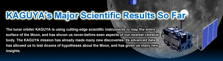
Lunar gravity anomalies. The nearside on the left, and the farside on the right. Red indicates strong gravity (positive gravity anomalies), and blue indicates weak gravity (negative gravity anomalies). The lunar gravity anomalies are different on the nearside and farside.
Gravity changes according to elevation: it is stronger over higher elevations and weaker over lower elevations. But topography isn't the only variable that affects gravity; its strength also depends on the subsurface structure: stronger gravity is observed over an area with heavier than average materials, such as iron oxide, and weaker gravity is observed over an area with lighter rocks. Using onboard sensors and relay satellites to map local gravity all over the Moon, KAGUYA has revealed the different gravity anomalies (the differences between the observed gravity and the average gravity) on the lunar nearside and farside. By comparing the Moon's gravity distribution and topographic data, we have identified a relationship between impact basins and gravity anomalies. (On the Moon, a large crater with a diameter of more than 200 kilometers is called a basin. A plain, created when a depression (crater) has been filled by lava erupting from the interior, is called a lunar mare (plural: maria)). Although scientists had previously known about lunar gravity anomalies, KAGUYA's observation data has provided a much more detailed profile.
KAGUYA has also collected gravity anomaly data on lunar maria. On the nearside they are made up of heavy materials, and contain mascons (mass concentrations) that are positive gravity anomalies - i.e., the local gravity is stronger than average. Hypothetically, when a celestial body hit the Moon's surface, the temperature and pressure of the lunar interior increased, and the softened and easily distorted interior material pushed up the mantle, causing the eruption of high-density lava and producing a mascon. On the farside, on the other hand, there are few lunar maria. The farside has no mascons - positive gravity anomalies - but rather a number of negative gravity anomalies in craters and basins, which are all topographically round-shaped. Scientists believe that on the farside, the interior of the Moon was at lower temperatures and thus more firm. As a result, when large celestial objects impacted the Moon and impact basins were formed, there was less crustal uplift and lava eruption, and thus no density anomalies.
KAGUYA's gravity measurements suggest that approximately 4 billion years ago, when most of the Moon's impact topography (craters, basins and maria) was formed, its interior was hot on the nearside but cold on the farside, resulting in the variation in the firmness of the crust on the near and far sides.
The lunar crust is thought to have formed from cooled and solidified magma oceans, and the different firmness of the crust on the near and far sides probably derives from their different cooling speeds: the crust on the nearside kept warm for a few hundred million years after the birth of the Moon, while that on the farside cooled down quickly.
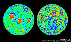
Topographic map of the Moon. The black dot and white dot indicate the highest and lowest elevations on the Moon, respectively.
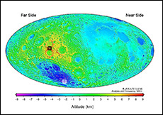
Topographic maps of the polar regions show the Shoemaker (Sh), Faustini (Fa), Shackleton (S), and de Gerlache (dG) craters.
KAGUYA has about 6,770,000 data points on the Moon, on average five to six kilometers apart. With its laser altimeter (LALT), KAGUYA has made the first accurate global topographic map of the Moon. (The previous map was based on only 270,000 data points and lacked data on the polar regions.) We now know that the highest elevation on the Moon is about 10,750 meters at a crater rim on the farside, and the lowest is about 9,060 meters deep in the Aitken Basin, at the South Pole - also on the farside. The difference between the highest and lowest points was previously speculated to be about 17,530 meters, but KAGUYA has revised this to about 19,810 meters, more than 2 kilometers greater. It has also accurately mapped the topography at altitudes lower than 200 to 300 meters, such as ridges in lunar maria.
KAGUYA provided the first measurements of the elevations across both polar regions. Because the distance between data points in these regions is less than two kilometers, even small craters with a diameter of two to three kilometers can be clearly detected. KAGUYA has also revealed the topography on the farside, which is not visible from Earth, such as the inside of the Shackleton Crater and the de Gerlache Crater at the South Pole, as well as a roughly 15-kilometer crater inside the de Gerlache crater. The topographic map will be very useful for choosing landing points for lunar explorers and possible locations for a future lunar base.
KAGUYA provided the first measurements of the elevations across both polar regions. Because the distance between data points in these regions is less than two kilometers, even small craters with a diameter of two to three kilometers can be clearly detected. KAGUYA has also revealed the topography on the farside, which is not visible from Earth, such as the inside of the Shackleton Crater and the de Gerlache Crater at the South Pole, as well as a roughly 15-kilometer crater inside the de Gerlache crater. The topographic map will be very useful for choosing landing points for lunar explorers and possible locations for a future lunar base.
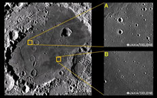
Vicinity of the Mare Moscoviense (Sea of Muscovy: 27ºN, 148ºE, approximately 200 km in diameter), imaged by Kaguya's Terrain Camera. Based on crater density, some regions turned out to have been formed as recently as 2.5 billion years ago.
The volcanic activity in the lunar maria on the farside was previously believed to have ended more than 3 billion years ago, but Kaguya has confirmed that magma eruption actually continued until 2.5 billion years ago. Details of the volcanic history of the lunar farside are just beginning to emerge.
The age of a lunar region is determined using a method called crater counting: the greater the number and density of craters, the older we assume the region to be. Using its onboard Terrain Camera, which has 10-meter resolution to observe the degtail of the lunar surface, Kaguya was able to detect craters as small as 200 to 300 meters in diameter. By counting craters in the lunar maria on the farside, we have discovered many regions that formed about 2.5 billion years ago. Lunar maria are formed when magma erupts from the interior, so that suggests that, at least until 2.5 billion years ago, there was a heat source on the farside to continue volcanic activity in the interior. Thus, the volcanism on the lunar farside lasted at least 500 million years longer than previously estimated. Research will continue to find out what happened to the Moon in that period of time.
The age of a lunar region is determined using a method called crater counting: the greater the number and density of craters, the older we assume the region to be. Using its onboard Terrain Camera, which has 10-meter resolution to observe the degtail of the lunar surface, Kaguya was able to detect craters as small as 200 to 300 meters in diameter. By counting craters in the lunar maria on the farside, we have discovered many regions that formed about 2.5 billion years ago. Lunar maria are formed when magma erupts from the interior, so that suggests that, at least until 2.5 billion years ago, there was a heat source on the farside to continue volcanic activity in the interior. Thus, the volcanism on the lunar farside lasted at least 500 million years longer than previously estimated. Research will continue to find out what happened to the Moon in that period of time.
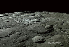
The lunar North Pole imaged by KAGUYA's high definition camera. In the polar regions, no place is permanently sunlit.
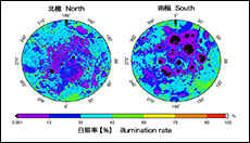
Illumination rate of the polar regions. Black indicates the regions in permanent shadow. Secondary scattering of sunlight is not counted.
The equatorial plane of the Earth is tilted relative to the ecliptic plane (the orbital plane of the Earth) by an angle of 23.4º, but that of the Moon is tilted by an angle of only 1.5º, which is almost perpendicular. Based on this, scientists had speculated that in the polar regions of the Moon, some high mountains would have permanent sunlight and the bottom of some deep craters would be in permanent shadow.
Topographic data for the polar regions were collected by KAGUYA's laser altimeter to determine the illumination rate (percentage of days with sunlight in a year). The result shows that the maximum illumination rate is 89 percent in the North Pole region, and 86 percent in the South Pole region. In other words, there is no place in permanent sunlight on the Moon. Sunlight will be a critical energy source for a future lunar base, so defining a region with a high illumination rate is very important for choosing possible locations for a lunar base. For the same reason, it is crucial to obtain information about the areas of permanent shadow, where there is likely to be water ice, another key resource.
Topographic data for the polar regions were collected by KAGUYA's laser altimeter to determine the illumination rate (percentage of days with sunlight in a year). The result shows that the maximum illumination rate is 89 percent in the North Pole region, and 86 percent in the South Pole region. In other words, there is no place in permanent sunlight on the Moon. Sunlight will be a critical energy source for a future lunar base, so defining a region with a high illumination rate is very important for choosing possible locations for a lunar base. For the same reason, it is crucial to obtain information about the areas of permanent shadow, where there is likely to be water ice, another key resource.