
Location on Earth detected from space
The information we can get through satellite positioning is location (x,y,z) and time. Satellite positioning is technology to calculate location and time based on ranging data collected through the calculation of distance between a receiver and satellites by receiving radio waves from four satellites.First, a receiver sources signals from satellites to calculate "time" (how long signals took) for radio waves to reach an antenna of the user's receiver from the satellites. The signals transmitted from the satellite include time data, thus the difference between the time data and the receiving time is the "time." This "time" is called the "(radio wave) propagation time." The distance between the satellites and the receiver can be calculated by multiplying this "propagation time" by radio wave speed (light speed = 299,792,458m/second.)
Distance between the receiver and the satellites = propagation time x radio wave speed
You cannot find out your location and the distance using only one satellite. Four satellites are required. The distance between you and each of the four satellites shall be calculated one by one, then four distances are met at one point (Figure 1.) This point should be your location.
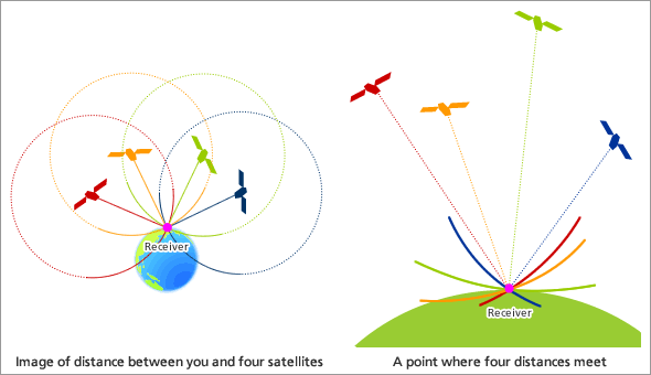
Figure 1
*If the clock in a ground receiver is very precise, location can be specified only with three satellites. However, time in a ground receiver often has a slight error, hence information from one more satellite is more helpful to acquire accurate time data.
Logic of satellite positioning
World's best clock is in satellites
For all kinds of positioning methods, including satellite positioning, the most important factor is "precise time." Users calculate location based on the assumption that time information transmitted through a satellite radio wave is correct. A radio wave travels about 300,000 km per second; therefore, a time lag of one micro second (1/1,000,000 second) results in 300 meters of a ranging error.In other words, if we can get location information with an accuracy of 300 meters, it means that we can acquire time with an accuracy of 1 micro second.
Those who use car navigation may not know that you can gain not only location but also precise time if you conduct ranging calculations. In addition to acquiring location information, the GPS is also useful to precisely measure an epicenter of an earthquake as such an observation requires accurate time synchronicity at many locations.
The GPS is equipped with a Cesium Atomic Clock and a Rubidium Atomic Clock. The errors of those atomic clocks are said to be less than one second in 300,000 years. Two rubidium atomic clocks are installed in the quasi-zenith satellite.