 A.1 By receiving a complementary signal for the GPS from the MICHIBIKI, which flies above you, the possible time percentage of positioning availability will improve from about 90 % (only with the GPS) to 99.8 % (GPS + three QZSes*.)
In addition, if any anomaly occurs in a QZS or the GPS, it will be notified very quickly to users (within about 20 to 30 seconds) by monitoring from ground stations as the positioning reliability will improve with the QZSes.
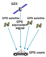
What is "GPS complementary"? The MICHIBIKI transmits almost an equivalent positioning signal as the GPS signal. By combining the MICHIBIKI and the GPS, the area and time of positioning availability will be expanded.
* With only one QZS, we can see the MICHIBIKI above us in the Tokyo area for about eight hours per day. With three QZSes, the QZS system can cover for 24 hours.

By transmitting the GPS equivalent signal, it has the same effect as one more GPS satellite flying above you.
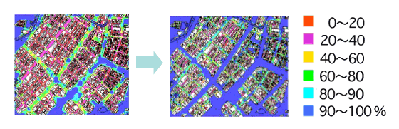
(Figure 1) Time percentage of positioning availability with GPS satellites only (left) and when QZSS is added (right)
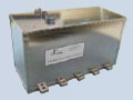
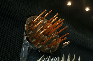 A.2 The horns are helical array antennas that can make signal strength constant and uniform when the signal is received on the ground.
The multiple number of satellite positioning systems, including the American GPS, Russia's GLONSS, and EU's GLILEO, share the same radio frequency; therefore, each satellite has to make the output signal strength constant and uniform within a certain predetermined range. Unlike other positioning systems, the MICHIBIKI flies on an elliptical orbit whose distance from the ground changes. The signal strength has to be constant when received on the ground by incorporating the changing distance to the Earth. In addition, the MICHIBIKI's orbit is higher in altitude than other systems, thus it has to transmit a stronger signal. For sending stronger signals that are constant in strength when received on the ground, the MICHIBIKI has an array antenna composed of 19 helical antennas that look like horns.

Actually, there are 19 horns sticking out inside of it. Surprised? To make a uniform amplitude distribution of the signal, an antenna pattern is formed in a dent shape. It is very high-tech.
The MICHIBIKI's helical array antenna is the "L-band helical array antenna." It is an array antenna using an L-band consisting of (or arraying) antenna elements coiled in the form of a helix.
The MICHIBIKI's antenna is made of 19 helical antenna elements, and it is an extremely high performance antenna with high gains to constantly transmit a uniform signal level to users on Earth, whose surface is curved, thus the distance between the satellite and the ground changes.
 Firstly, the clock aboard the MICHIBIKI is incredible!
Unless the satellite location information and time information sent from a positioning satellite are accurate, we cannot calculate where we are precisely. A slight time lag of one micro second (one-millionth of a second) can lead to a positioning error of 300 meters. (For more details, please refer to: http://www.jaxa.jp/countdown/f18/overview/gps_e.html)
For the above reason, the satellite is equipped with an extremely precise and highly stable "rubidium atomic clock." Furthermore, we take special care with electric wiring and temperature management to minimize the gap in the radio wave phase and frequency.
Secondly, the MICHIBIKI is designed to promptly cope with signals in a new generation. It takes the future into consideration!
Around the time of the MICHIBIKI launch, various new satellite positioning systems are scheduled to begin operations. The GPS is also scheduled to be modernized to begin transmitting new signals. The MICHIBIKI is designed to deal with not only current GPS signals but also future ones.
Positioning monitor experiment stations are set up mainly in Japan as well as in other areas that can receive MICHIBIKI signals, such as in India, Thailand, and Hawaii, to receive and monitor the location and time information from the MICHIBIKI.
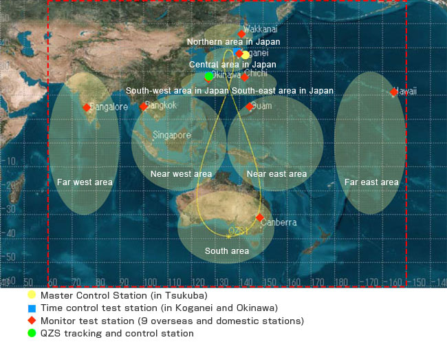
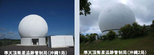 In addition to the above experiment stations, there are ground support systems for the MICHIBIKI, and, among them, we would like to especially focus on the QZS tracking station prepared in Okinawa to operate the MICHIBIKI 24 hours a day, seven days a week. The station's antennas are covered by a dome for coping with adverse weather conditions including typhoons.
Let MICHIBIKI-san explain more about the station.
I'd like to explain the QZS tracking station exclusively prepared for me. It is exclusively for me because I am a positioning satellite, thus I need to be uploaded with data that improves my accuracy, such as orbit and time information, around the clock. You may wonder why the station is in Okinawa. It is because I am flying over Japan to Australia, thus, the Okinawa station can always watch me as it is closer to the equator. There are two antennas as the capacity utilization rate was taken into account. Also, they are covered by a protective dome called a "radome" to avoid transmission interruption when adverse weather such as typhoons hits. (The antennas are in white dome covers.) The radome is superb as it can transmit radio waves while being strong enough to withstand typhoons. The used radio frequency is the C-bandwidth of 5 GHz, which is less affected by precipitation attenuation. I am looking forward to talking to the QZS tracking station when I arrive in space. (MICHIBIKI-san Twitter on July 1.)
I am often asked why my main body color is not gold like AKATUSKI-san and IBUKI-san, but black.
It is the color of the multi-layer insulator (MLI) pasted on me.
The type of insulator depends on the satellite. I am in a category of geostationary satellites, and the recent geostationary satellites including the KIZUNA-san (WINDS) and KIKU No. 8-san (ETS-VIII) are also black.
The black MLI is slow in the deterioration of thermal optical characteristics, thus black ones are used more for geostationary satellites, whose life expectancy is usually longer. My design life is 10 years, which is fairly long, thus I have to work hard to keep staying healthy.
Other satellites also use the black MLI for different reasons. For example, I heard that a satellite that wants to avoid reflections or that has special consideration to conductivity may use black. (MICHIBIKI-san Twitter on June 28.)