Image data acquired by the PALSAR onboard the "Daichi"
Minister of Economy, Trade and Industry (METI)
Japan Aerospace Exploration Agency (JAXA)
The Ministry of Economy, Trade, and Industry (METI) and Japan Aerospace Exploration Agency (JAXA) would like to announce that image data was successfully acquired by the Phased Array type L-band Synthetic Aperture Radar (PALSAR) onboard the Advanced Land Observing Satellite "Daichi," which was launched on January 24, 2006 (Japan Standard Time, JST). The data was acquired as part of the initial functional verification test.
The attached images of Mt. Fuji and Izu Peninsular (Diagram 1) and Shizuoka City (Diagram 2) were observed by the PALSAR at 10:16 p.m. on Feb. 15 (JST), and later received at the Earth Observation Center (in Hatoyama-cho, Hiki-gun, Saitama Pref.)
The PALSAR is the only satellite that uses onboard phased array type synthetic aperture radar with L-band by which observations are less affected by conditions on the earth's surface. By observing the same location on the earth twice (interference processing), the observation accuracy for the elevation and subsidence on the earth can be as close as a few centimeters.
Note: The PALSAR was developed by the METI in cooperation with JAXA. At the METI, the Japan Resources Observation System Organization (JAROS) is in charge of developing the electric equipment, and the Earth Remote Sensing Data Analysis Center (ERSDAC) is in charge of data processing and its use and research.
|
|
Note: Spatial resolution indicates the physical size of an object that can be distinguished in an image.
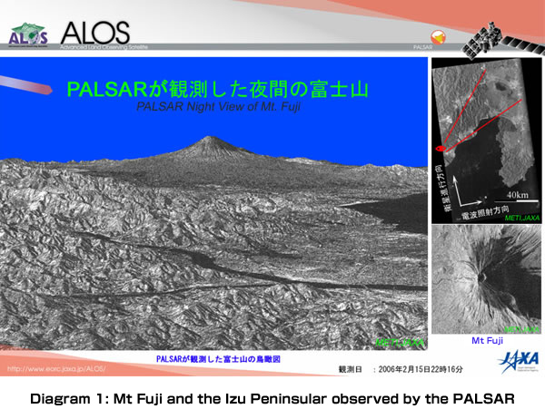
Diagram 1 is image data on Mt. Fuji and the Izu Peninsular observed by the Phased Array type L-band Synthetic Aperture Radar (PALSAR) onboard the Advanced Land Observing Satellite "Daichi" during the night (around 10:16 p.m.) on February 15, 2006 (JST), when the satellite passed over the Bunngo Suidou area from the south to the north. This night time image was observed at an angle of 41.5 degrees on the right from the PALSAR at a distance of 1,000 km.
The left image is a bird's-eye view compiled by using numerical information from the land of the Geographical Survey Institute based on the right top image data of the whole area between Mt. Fuji and the Izu Peninsular (70 km in width and 140 km in length) observed by the PALSAR. The right bottom image is an enlarged image of the top of Mt. Fuji. Oosawa landslide on the west side is visible, as are other detailed geographic features of the mountain top.
The PALSAR is a synthetic aperture radar using microwaves that can carry out observations day and night regardless of weather conditions. The data was acquired during night observation, and, although light rain was falling, the PALSAR acquired very good data.
Note: Spatial resolution indicates the physical size of an object that can be distinguished in an image.
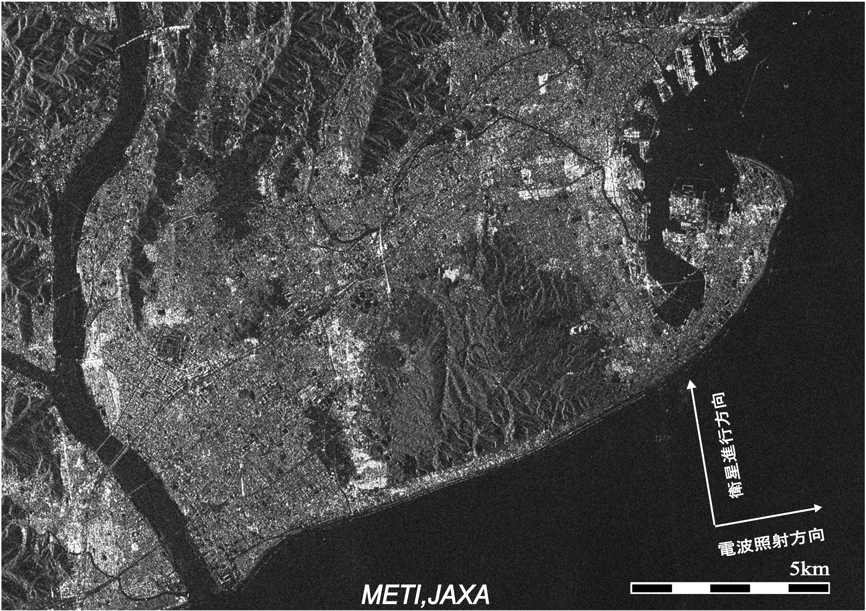
Diagram 2 is image data on Shizuoka City observed by the Phased Array type L-band Synthetic Aperture Radar (PALSAR) onboard the Advanced Land Observing Satellite "Daichi" during the night (around 10:16 p.m.) on February 15, 2006 (JST.) On the right (or the east side), you can find Shimizu Port and the Miho Peninsular, which is famous for the Hagoromo (or a feather robe) folk tale, a hilly area called "Nihon Daira" in the center, and the city center of Shizuoka City in the frame on the left (or the west.)
The black line from the top (north) to the bottom (south) on the west end is the Abe River, and, on its west side, you can find the fault "Itoigawa-Shizuoka Line" that divides the west side of the Fossa Magna along the hilly area located parallel with the Abe River.
In images taken by a synthetic aperture radar, the harsh ups and downs on land such as mountains are shown as light and dark contrasts or in clear stripes, and city areas are shown as detailed mosaics due to a strong rear light dispersion caused by artificial (man-made) horizontal and vertical planes.
The character of a synthetic aperture radar allows it to carry our observations day and night regardless of weather conditions.
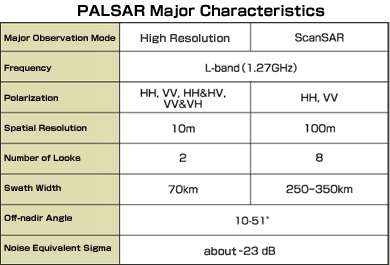
Phased Array type L-band Synthetic Aperture Radar (PALSAR)
 |
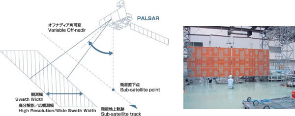
The PALSAR is an upgraded Synthetic Aperture Radar (SAR) onboard the Japan Earth Resources Satellite-1 (JERS-1) with improved function and performance. It is an active type microwave sensor which can carry our observations day and night regardless of weather conditions. The PALSAR is equipped with a function to change its observation direction and observation mode to cover wider range (Scan SAR.) The radar is developed in cooperation with the Japan Resources Observation System Organization (JAROS) of the Ministry of Economy, Trade and Industry (METI.) |
 |
|
 |
|
For inquiries:
JAXA Earth Observation Research and Application Center
Tel: + 81-3-6221-9008
Fax: +81-3-6221-9191
Earth Remote Sensing Data Analysis Center
Tel: +81-3-3533-9312
Fax: +81-3-3533-9383