Stricken Area in central Java, Indonesia Observed by
Advanced Land Observing Satellite "Daichi" (ALOS)
Japan Aerospace Exploration Agency (JAXA)
Today, the Japan Aerospace Exploration Agency (JAXA) observed the central Java, the Republic of Indonesia, which was severely stricken by an earthquake on May 27, using the two onboard sensors of the Advanced Land Observing Satellite "Daichi" (ALOS), the Phased Array type L-band Synthetic Aperture Radar (PALSAR) and the Advanced Visible and Near Infrared Radiometer type 2 (AVNIR-2), to provide observation data to the International Charter "Space and Major Disaster"*1 and the National Institute of Aeronautics and Space of Indonesia (LAPAN) *2. The data is shown in the attachment.
* The PALSAR was developed by JAXA in corporation with the Ministry of Economy, Trade, and Industry.
*1: The International Charter "Space and Major Disaster": please refer to the reference bellow.
*2: The National Institute of Aeronautics and Space of Indonesia (LAPAN): please refer to the reference below.
|
|
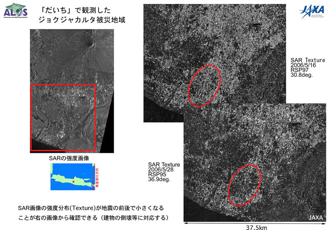
Figure 1
Figure 1 is a comparison of images around Yogyakarta taken by the Phased Array type L-band Synthetic Aperture Radar (PALSAR). The image on the bottom right was acquired at 11:40 a.m. on May 28 (Japan Standard Time, JST) and the upper right one was observed before the earthquake (May 16, this year, JST.)
Comparing the distribution of reflection strength (texture) of PALSAR radar waves before and after the earthquake (May 16, and 28 respectively), we confirmed that the reflection strength became weaker (or darker in the image) after the earthquake not only in the nearby area of the epicenter but all over the city area. (You can see a clearer difference especially in the area encircled in red.) In general, the strength distribution of radar reflection wave is bigger in city areas and smaller in forests.
The reduction of texture means that the earthquake was big enough to destroy artificial structures such as buildings.
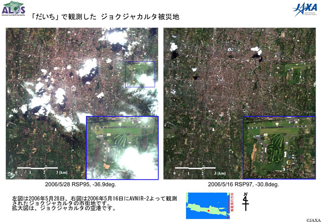
Figure 2
The left image is the Yogyakarta city center taken by the Advanced Visible and Near Infrared Radiometer type 2 (AVNIR-2) at 11:40 a.m. on May 28 (Japan Standard Time, JST.) The right is the same area acquired on May 16 (JST.)
International Charter "Space and Major Disasters"
(1) Official Name
Charter on Cooperation to Achieve the Coordinated Use of Space Facilities in the Event of Natural or Technological Disasters
(2) Member Organizations and Satellites in Use
| Member Organizations | Satellite in Use |
|---|---|
| European Space Agency (ESA) | ERS, ENVISAT |
| French Space Agency (CNES) | SPOT |
| Canadian Space Agency (CSA) | RADARSAT |
| Indian Space Research Organization (ISRO) | IRS |
| National Oceanic and Atmospheric Administration (NOAA), United States Geological Survey (USGS) |
POES, GOES, LANDSAT |
| Argentine Space Agency (CONAE) | SAC-C |
| BritishNationalSpaceCenter (BNSC) | DMC (Disaster Monitoring Constellation) |
| Japan Aerospace Exploration Agency (JAXA) | ALOS (After starting its regular operation) |
(3) Objective
The International Charter established in 2002 is a framework to promote contributions from each space organization to help disaster stricken areas by providing data acquired by earth observation satellites for free based on the best efforts of the member organizations.
(4) Cooperative Structure
- Organized by member organizations and disaster related organizations.
- No financial exchange takes place among participating organizations.
- Activities are coordinated by the committee of representatives from each organization and the secretariat of the International Charter.
International Charter URL: http://www.disasterscharter.org/main_e.html
National Institute of Aeronautics and Space of Indonesia (LAPAN)
JAXA and LAPAN have been promoting the pilot project for verification and utilization of observation data acquired by the "Daichi" (ALOS) since Japan Fiscal Year 2005. JAXA provides "Daichi" observation data to LAPAN, and LAPAN is scheduled to use the observation data in corporation with the Indonesian Government.
For inquiries:
JAXA Disaster Management Support Office (DMSO)
Tel: +81-3-3516-9106, 9117
Fax: +81-3-3516-9160