Release of "Global Rainfall Map in Near Real Time"
Using TRMM and Other Satellites
Japan Aerospace Exploration Agency (JAXA)
Japan Science and Technology Agency (JST)
The Earth Observation Research Center (EORC) of the Japan Aerospace Exploration Agency (JAXA) has started to release image data of a high-resolution global precipitation distribution map in quasi real time (about four hours after observations) on the Internet. The map is composed by the EORC using acquired data by earth observation satellites including the Tropical Rainfall Measuring Mission (TRMM.)
The image data is updated every hour, and you can also see the animated image of precipitation distribution over the last 24 hours.
The establishment of this quasi real-time provision system of image data enables us to timely offer information to regions, such as developing countries in Asia, which do not have enough data on precipitation although they are often hit by typhoons and heavy rainfall.
To calculate the volume of precipitation, we use the cutting-edge research results acquired by high time-space resolution mapping technology of the "GSMaP" project* of the Japan Science and Technology Agency (JST) and the TRMM onboard Precipitation Radar (PR.)
* GSMaP (Global Satellite Mapping of Precipitation) project
One of the projects of the research theme "Production of High Precision and High Resolution Global Precipitation Map by using Satellite Data" (led by Kenichi Okamoto, Professor, Osaka Prefecture University) in the area of "Core Research for Environment Science and Technology (CREST): Hydrological System Modeling and Water Resources System" (Research Chief: Dr. Katumi Mushiake, Professor, Fukushima University)
[To access the website]
JAXA/ EORC Global Rainfall Map in Near Real Time: http://sharaku.eorc.jaxa.jp/GSMaP/index.htm
Reference
The data that JAXA uses for this system is acquired by the TRMM Microwave Imager (TMI,) the Advanced Microwave Scanning Radiometer for the EOS (AMSR-E) onboard the Aqua Satellite, the SSM/I sensors onboard the Defense Meteorological Satellite Program (DMSP,) and other geostationary meteorological satellites. It is first time in Japan to constantly release global precipitation distribution data that is updated every hour by visualizing global data estimates based on satellite observations in quasi real time (about 10 square kilometers on the equator and average precipitation distribution for an hour.) We are now able to provide image data every hour by estimating precipitation volume based on the information of the movement of rain areas through cloud images acquired by geostationary meteorological satellites. Data provision within four hours after observation is one of the world's quickest data provision systems using a microwave radiometer such as the AMSR-E.
JAXA, in cooperation with the Public Works Research Institute, is also researching a method to improve the application of this system to predicting floods, which is expected to contribute to reduce flood damage in developing countries and other regions. In addition, we are now able to measure the precipitation volume of a typhoon in the ocean, which is expected to be useful for improving typhoon prediction verification and prediction accuracy.
Satellites and Sensors
TRMM (Tropical Rainfall Measuring Mission)
The Japan-US cooperative mission was launched by an H-II Launch Vehicle in Nov. 1997. This satellite specifically targets measuring precipitation in tropical and subtropical zones by using its three onboard precipitation observation sensors namely the Precipitation Radar (PR) developed by Japan, the TRMM Microwave Imager (TMI) developed by the US, and the Visible Infrared Scanner (VIRS) also developed by the U.S. The TRMM is still under operation as of Nov. 2007, and will celebrate its 10th year anniversary on Nov. 28.
AMSR-E on Aqua
The Advanced Microwave Scanning Radiometer for the EOS onboard the American Earth Observation Satellite "Aqua" was launched in May 2002. The AMSR-E is developed and operated by JAXA. It can observe precipitation volume, ocean surface temperatures, and sea ice distribution regardless of weather conditions and time of day by observing minute radio waves emitted from the Earth. The AMSR-E is currently under operation as of Nov. 2007.
SSM/I on DMSP
This is a microwave radiometer onboard the Defense Meteorological Satellite Program (DMSP) Series of the U.S. Since the first SSM/I sensor was onboard the DMSP-F8 launched in 1987, the sensor has been aboard successive DMSP series. Two to three SSM/I sensors are always in operation, and we use data from the sensors on F 13, 14, and 15 for this system.
Related Link
JAXA/EORC TRMM Project Website
http://www.eorc.jaxa.jp/TRMM/index_e.htm
JST/CREST GSMaP Project Website
http://www.radar.aero.osakafu-u.ac.jp/~gsmap/index_english.html
JST/CREST "Hydrological System Modeling and Water Resources System" Website
http://www.yae-mizu.jst.go.jp/yae-mizu/english-version/index-english/index-english.html
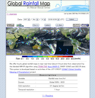
The above image is the precipitation distribution at 0:00 a.m. on Nov. 7, 2007 (UT.) The cloud images were provided by the Japan Meteorological Agency (JMA), EUMETSAT (European Organization for the Exploitation of Meteorological Satellites), NOAA (National Ocean and Atmospheric Administration of the U.S.) and the Japan Weather Association (JWA).
The above image is the precipitation distribution at 0:00 a.m. on Nov. 7, 2007 (UT.) The cloud images were provided by JMA, EUMETSAT, NOAA and JWA.
|
|