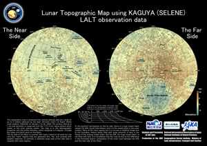
Topography of entire lunar surface using data from KAGUYA(SELENE) LALT
- 6 million pieces of lunar surface range data captured by LALT (10 times larger than ULCN 2005) -
National Astronomical Observatory of Japan (NAOJ)
Geographical Survey Institute (GSI)
Japan Aerospace Exploration Agency (JAXA)
The Laser Altimeter (LALT) aboard JAXA's lunar explorer KAGUYA (SELENE) captured data on the entire lunar surface height. The Lunar topographical map was produced by the Geographical Survey Institute (GSI) from the LALT product of the National Astronomical Observatory (NAOJ).
The LALT is able to obtain a range of data on a global scale along the satellite's trajectory including the high latitude region above 75 degrees that has never been measured by an altimeter. The number of measurement points as of this March is about 6 million and it is more than 10 times larger than the number for the ULCN 2005 model. The continuous range data of the LALT will enable us for the first time in the world to construct an accurate and precise global topographic map of the Moon.
The LALT's topography is important for the investigation of the internal lunar structure through analysis of the gravity/topography data of the moon (new accurate lunar gravity data, including from the far-side, will be obtained from the RSAT/VRAD mission of the KAGUYA.).
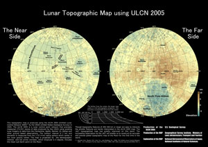
* The ULCN 2005 (Unified Lunar Control Network 2005) is a lunar control point network that precisely measured 272,931 pieces of data produced by the USGS using existing lunar imagery or data from the Clementine and other observations.
Lunar topographical map
| Lunar Topographic Map using KAGUYA (SELENE) LALT observation data |
Lunar Topographic Map using ULCN 2005 |
 TIFF(7.3MB) |
|
|