KAGUYA (SELENE) Last shot 3D movie composition using Terrain Camera Images during controlled impact operation
Japan Aerospace Exploration Agency (JAXA)
The Japan Aerospace Exploration Agency (JAXA) successfully produced stereo movies (3 dimensional movies) of the Moon's surface by using stereoscopic images obtained with the Terrain Camera (TC) onboard the KAGUYA just prior to its controlled impact to the Moon on June 11, 2009 (JST). The KAGUYA was launched by JAXA on September 14, 2007.
The movie was composed using TC cameras that respectively face slightly diagonally forward and aft of the satellite about 12 minutes prior to the KAGUYA's controlled impact on the Moon. Because the KAGUYA was in a very lower altitude orbit, the spatial resolution of 3D images taken this time was higher than previously captured data. Thus we can see the very precious features on the Moon's surface thanks to this low altitude observation.
After acquiring the data, the KAGUYA flew into the shaded area where it ultimately hit the Moon, hence it became too dark for the KAGUYA's optical cameras to capture the Moon's surface data. Therefore, observation data by one of the TC cameras soon after capturing the observation data for 3D images were the very last shots of the Moon by the TC.
On the other hand, the Multi-band Imager (MI) also successfully obtained final data one revolution before the TC did.
You can enjoy the 3D movie by the TC through the following JAXA website: Digital Archives, the KAGUYA Image Gallery, and the JAXA channel on YouTube. We will release KAGUYA processed data for science research through the Internet from Nov. 1. We will also hold a public event to report the achievements of the KAGUYA in Akihabara (Tokyo) between July 18 and 19, 2009.
[JAXA Website Digital Archivs]
http://jda.jaxa.jp/jda/v1_e.php
(Search by selecting the following: Subject: Observation Images, Category: Moon and Planet Exploration, Mission: Moon)
[JAXA KAGUYA Image Gallery]
http://wms.kaguya.jaxa.jp
[YouTube JAXA Channel]
http://www.youtube.com/jaxachannel
[KAGUYA Public Event Official Website]
http://www.sayonara-kaguya.jp
|
|
(1) Terrain Camera
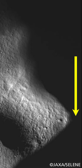
Figure 1. The last shot Moon surface image with the aft camera of the Terrain Camera with correcting altitude effect (Yellow allow shows flight direction, from North to South)
Observation Date: 3:15:52 - 3:16:00 on June 11, 2009 (JST)
Observation Location (center of image): 83S,260E
Satellite Altitude: About 18.5km
Effect correction method: 5.4 times interpolation processing in along track direction
* Because there are fixed values of sampling the intervals of both Terrain camera and Multi-band imager to observe the Moon and the speed of the KAGUYA at impact orbit was almost the same as its speed at 100km orbit, the spatial resolution in along track direction is 10 meters for TC and 20 meters for MI. On the other hand, in the cross track direction, a spatial resolution at 18.5km altitude is 5.4 times higher than it at 100km altitude orbit. Thus, since there is spatial resolution difference between the along track direction and the cross track direction, the TC image is collapsed in a vertical direction. To correct it to the image put together on the direction of the crossing track where the resolution is good, the interpolation processing is given.
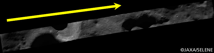 Ortho image derived from stereoscopic pair images of TC 3.8 km × 43.8 km(Yellow allow is flight direction from North to South) |
|
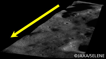 Upper right to bottom left |
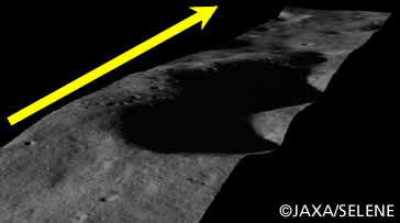 Bottom left to upper right |
Figure 2 Last shot of TC 3D image and movie
Observation date: 3:12:25 - 3:12:55 on June 11, 2009 (JST)
Observation location: 73.5S, 260.5E (center of image)
Altitude: about 25km
Processing: 2.5 times interpolation in flight direction
Movie : 3D movie taken by the Terrain Camera (TC) of KAGUYA (SELENE) during its maneuvered falling to the Moon [HD] (Youtube JAXA Channel)
The last shot of the TC movie is derived from the 3D image shown in figure2. At the beginning of the movie, the person who is standing in the place at a height of the surface of the Moon of about 2300m descends gradually, and the height has been changed by about 400m at the end of the movie.
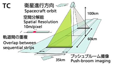
Observation principle of TC
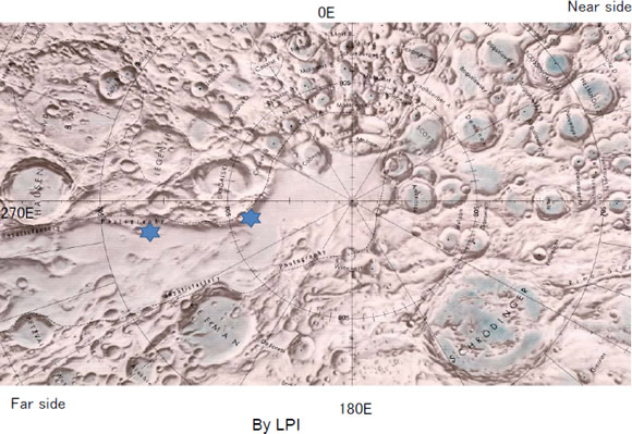
Star marks are TC observation locations
Left star is location of last shot of 3D image (figure 2 image)
Right star is location of last shot of TC image (figure 1 image)
(2) Multi-band imager
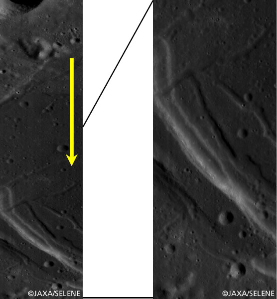
Figure 3 Last shot image of Multi-band imager
(Left image is original observation data and right image is altitude corrected image with 1.56 times interpolation processing in flight direction. Yellow arrow shows satellite flight direction.
Observation date: 1:03:52 - 1:04:37 on June 11 (JST)
Observation location: Western edge of Mare Orientale
(23S, 261.7E - 25.6S, 262.2E)
Satellite Altitude: about 64km
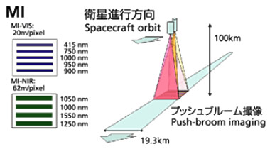
Observation principle of MI