About Advanced Land Observing Satellite-4 “DAICHI-4”(ALOS-4)
 |
Taking over from DAICHI-2 to enhance the functionality and performanceThe Advanced Land Observing Satellite-4 (ALOS-4) is a satellite to observe the Earth's surface using its onboard phased array type L-band synthetic aperture radar (PALSAR-3). The L-band radar technology has continuously been developed in Japan. With further improved observation performance compared to the predecessor PALSAR-2 aboard the DAICHI-2 (ALOS-2), JAXA and its prime contractor, Mitsubishi Electric Corporation, are developing the satellite aiming at achieving both high resolution and a broader observation swath. |
|---|
Characteristics of Advanced Land Observing Satellite-4“DAICHI-4” (ALOS-4)
Monitoring land deformation and subsidence
|
A radar satellite can measure diastrophism or ground transformation caused by volcanic activity or an earthquake up to a few centimeters by comparing acquired data in the same area at different times. For example, the location of a magma reservoir and its movement from surface displacement can be estimated by continuously monitoring volcanoes, and such an estimation can contribute to understanding volcanic activities. Data to be acquired by ALOS-4 will also be used for comparison with data acquired by DAICHI-2, which flies on the same orbit, to investigate changes. |
Swath covered by one observation in the stripmap mode 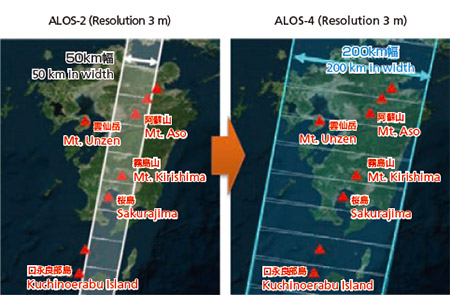 |
|---|
Figure 1 Comparing observation swath
Comparing observation swath
| Resolution | ALOS-2 | ALOS-4 |
|---|---|---|
| Stripmap mode (Resolution 3 m, 6 m, 10 m) | 50km, 70km | 100km-200km |
| ScanSAR mode (Resolution 25 m) | 350km, 490km | 700km |
| Spotlight mode (Resolution 1 m x 3 m) | 25km X 25km | 35km X 35km |
Comparison of observation frequency in Japan
| Resolution | ALOS-2 | ALOS-4 |
|---|---|---|
| Stripmap mode (Resolution 3 m) | Four times a year | 20 times a year (once every two weeks) |
Applications other than disaster prevention(e.g., forest management)
|
Forest covers 30 percent of the all land area in the world, and deforestation is strongly related to the increase of greenhouse gases. Therefore, forest conservation and assessment are important. JAXA and the Japan International Cooperation Agency (JICA) are cooperatively developing the JICA-JAXA Forest Early Warning System in the Tropics (JJ-FAST). Using observation data by DAICHI-2, the JJ-FAST can detect areas of deforestation in the order of a few hectares in 77 countries. However, there are many smaller deforestation areas, hence we receive requests for more detailed and frequent observations. The ALOS-4 will conduct observations more frequently with five times more precision to detect smaller deforestation areas that cannot be monitored by DAICHI-2. |
Image of improved forest monitoring 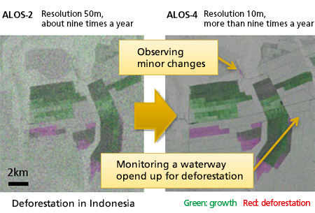 |
|---|
Monitoring infrastructure displacement
JAXA carries out research to detect the annual displacement of structure due to the deterioration of dams, levees, port facilities and other infrastructure by analyzing time series DAICHI’ s data. ALOS-4 will acquire data more frequently, thus we can detect annual displacement that grows slowly and gradually, such as structural distortion and subsidence, with precision of a few millimeters. Through such detailed observations, the satellite data is expected to be utilized for more efficient infrastructure maintenance.
Major Characteristics
| Sensor system | L-band synthetic aperture radar (PALSAR-3) Space-based Automatic Identification System Experiment (SPAISE3) |
|---|---|
| Size | 10.0m×20.0m×6.4m (D×W×H) |
| Mass | Approx. 3 tons |
| Design life | 7 years |
| Operational orbit | Sun-synchronous sub-recurrent orbit (At the same altitude as DAICHI-2’s orbit) |
| Launch Vehicle | H3 |
| Prime contractor | Mitsubishi Electric Corporation |