
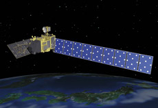
Advanced Land Observing Satellite Daichi (ALOS)
When we started looking for satellite applications that could aid in disaster management, the first thing that occurred to us was to use satellites to monitor and assess affected areas. When roads are blocked and airplanes and helicopters are grounded by bad weather, a satellite is still able to make observations. Today, Daichi images are already being used to monitor disasters, both in Japan and overseas.
Good disaster management requires more than emergency response. It's also very important to try to limit the damage through prevention and preparedness, and in the post-disaster phase to distribute information about relief efforts and reconstruction.
Taking all this into account, JAXA has formed the Disaster Management Support Systems Office (DMSSO) at the Satellite Applications and Promotion Center (SAPC), to integrate all disaster-related satellite applications. Apart from coordinating emergency observation, the office tries to meet the needs of outside institutions and experts who are involved in disaster management. JAXA is also proposing new satellite applications to aid in disaster prevention and response.
Q. Could you illustrate how cooperative systems for disaster management work in Japan?
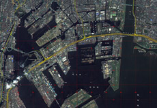
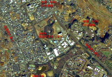
Satellite topographic map of southern Tokyo
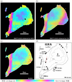
Analysis of the diastrophism of Iwo Jima
The main objective of Daichi was mapping, and we hoped that these maps would be useful in disaster management. Space programs has been drastically shifting recently from pure research and development to the real utilization of space. However JAXA is a space agency for R & D, and we are not experts in disaster management. So the Cabinet Office of the Government of Japan, and the Ministry of Education, Culture, Sports, Science and Technology established a committee to look at the potential of using satellites in disaster management. The committee brought together governmental bodies, institutions and experts to exchange opinions and explain their needs. We asked for their advice on how to present satellite images in a way that would facilitate their work. It was the first time JAXA heard directly from specialists in this field. There were six meetings in total, from February to August 2006. And now, we have working groups with members from the related ministries and institutions conducting demonstration tests in the different areas that were suggested in the committee.
The first interesting area is the production of topographic satellite maps, and their implementation in disaster management. For example, we are trying to use Daichi's images to create hazard maps, which illustrate the risks of damage from hypothetical disasters. By monitoring danger zones in advance, we hope to be able to predict the best escape routes when a natural disaster strikes.
Also, it's possible to make topographic satellite maps combining Daichi's images with digital maps published by the Geographical Survey Institute. To promote the use of these maps in early-response activities such as rescue crew dispatch just after disaster hits, we asked the National Police Agency, the Fire and Disaster Management Agency, and the Ministry of Defense about their needs. In response, we have made a 1/25,000-scale sample of a topographic satellite map of southern Tokyo. The map indicates emergency transportation routes in different colors, and notes key landmarks such as the locations of heliports. In addition, comparing pre- and post-disaster satellite images can help us pinpoint such things as collapsed buildings or fires, allowing us to assess damage much more easily. The sensor on Daichi is capable of 3D imaging. We generate 3D images of the entire nation, which would be available to all ministries working on disaster management.
We are also conducting demonstration tests to detect such natural phenomena as volcanic eruptions, movements of the Earth's crust, maritime and coastal disasters, landslides, and floods, and to assess the damage they cause. And we are carrying out joint demonstration to predict volcanic eruptions with many research institutions, including the Japan Meteorological Agency, the Geographical Survey Institute, and the National Research Institute for Earth Science and Disaster Prevention - all members of the Committee for the Prediction of Volcanic Eruptions.
What we have learned from these cooperative efforts, though, is that satellite imaging will have to improve before it can provide significant benefit in disaster management. The major benefit of satellite imaging is the ability to monitor a wide area at once and to acquire up-to-date information. For instance, to study a volcanic eruption, you need to compare pictures taken before and after the volcanic activity and look for subtle differences. So both timeliness and resolution are major issues. To achieve our goal of increased satellite use in disaster management we need to collaborate with end users. We need to outline the types of data we can provide, and to exchange ideas with them as to the best satellite applications to meet their needs.
The Tsukuba Space Center and its surroundings

Q. What kind of improvements are needed in satellite technology for disaster management?
At the committee to discuss satellite applications for disaster management, which I mentioned earlier, we also talked about the next generation Earth observation satellite. The most common requests were for improvements in resolution and swath width, and for faster information delivery. The resolution of the Panchromatic Remote-sensing Instrument for Stereo Mapping (PRISM) on Daichi is 2.5 meters, but disaster-management agencies are asking for one-meter resolution. Also, past data shows that earthquakes damage stretches between 40 and 70 km, and floods affect areas between 30 and 50 km in width. To cover such scope with a single image, the swath width needs to be about 50 km. Daichi is capable of 2.5-meter resolution and 70-kilometer swath width. But to meet disaster-management requirements, we need to develop a sensor with one-meter resolution and at least a 50-km swath width.
Another request has been that satellite information be released no more than 3 hours after a disaster has occurred, in order to promptly assess the damage. Daichi can only take images of the same area every 2 days. We would need four satellites to image the same area every three hours.
In the future, we would like to be able to monitor disasters in real time from a geostationary orbit, which will enable us to observe a specific area whenever necessary. We would like to develop the technology needed to do so.
The first interesting area is the production of topographic satellite maps, and their implementation in disaster management. For example, we are trying to use Daichi's images to create hazard maps, which illustrate the risks of damage from hypothetical disasters. By monitoring danger zones in advance, we hope to be able to predict the best escape routes when a natural disaster strikes.
Also, it's possible to make topographic satellite maps combining Daichi's images with digital maps published by the Geographical Survey Institute. To promote the use of these maps in early-response activities such as rescue crew dispatch just after disaster hits, we asked the National Police Agency, the Fire and Disaster Management Agency, and the Ministry of Defense about their needs. In response, we have made a 1/25,000-scale sample of a topographic satellite map of southern Tokyo. The map indicates emergency transportation routes in different colors, and notes key landmarks such as the locations of heliports. In addition, comparing pre- and post-disaster satellite images can help us pinpoint such things as collapsed buildings or fires, allowing us to assess damage much more easily. The sensor on Daichi is capable of 3D imaging. We generate 3D images of the entire nation, which would be available to all ministries working on disaster management.
We are also conducting demonstration tests to detect such natural phenomena as volcanic eruptions, movements of the Earth's crust, maritime and coastal disasters, landslides, and floods, and to assess the damage they cause. And we are carrying out joint demonstration to predict volcanic eruptions with many research institutions, including the Japan Meteorological Agency, the Geographical Survey Institute, and the National Research Institute for Earth Science and Disaster Prevention - all members of the Committee for the Prediction of Volcanic Eruptions.
What we have learned from these cooperative efforts, though, is that satellite imaging will have to improve before it can provide significant benefit in disaster management. The major benefit of satellite imaging is the ability to monitor a wide area at once and to acquire up-to-date information. For instance, to study a volcanic eruption, you need to compare pictures taken before and after the volcanic activity and look for subtle differences. So both timeliness and resolution are major issues. To achieve our goal of increased satellite use in disaster management we need to collaborate with end users. We need to outline the types of data we can provide, and to exchange ideas with them as to the best satellite applications to meet their needs.
The Tsukuba Space Center and its surroundings
At the committee to discuss satellite applications for disaster management, which I mentioned earlier, we also talked about the next generation Earth observation satellite. The most common requests were for improvements in resolution and swath width, and for faster information delivery. The resolution of the Panchromatic Remote-sensing Instrument for Stereo Mapping (PRISM) on Daichi is 2.5 meters, but disaster-management agencies are asking for one-meter resolution. Also, past data shows that earthquakes damage stretches between 40 and 70 km, and floods affect areas between 30 and 50 km in width. To cover such scope with a single image, the swath width needs to be about 50 km. Daichi is capable of 2.5-meter resolution and 70-kilometer swath width. But to meet disaster-management requirements, we need to develop a sensor with one-meter resolution and at least a 50-km swath width.
Another request has been that satellite information be released no more than 3 hours after a disaster has occurred, in order to promptly assess the damage. Daichi can only take images of the same area every 2 days. We would need four satellites to image the same area every three hours.
In the future, we would like to be able to monitor disasters in real time from a geostationary orbit, which will enable us to observe a specific area whenever necessary. We would like to develop the technology needed to do so.