Q. How will the QZSS benefit Japanese quality of life?
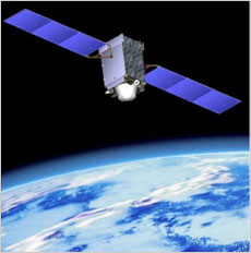
Quasi-Zenith Satellite
The QZSS provides positioning, navigation and timing (PNT) information; in other words, it pinpoints where an object is at a given time. The information has a broad array of potential applications, the most popular of which are car navigation and GPS mobile phones. Also, a system that automatically sends your location information when you call an emergency number for police or ambulance is already in use. I am sure that QZSS will help make our society more secure as it enhances the accuracy of positioning information and makes it ubiquitous. For example, if PNT information is applied to traffic systems, motorists can learn about, and better avoid, accidents or traffic jams. In addition, if a portable device that has both GPS and QZSS becomes available, it will be able to tell your exact location even when you are lost in the middle of mountainous terrain or in the bottom of a valley. QZSS will also enable quick responses to disasters, accidents, or crime scenes. Other contributions will be made in the areas of mapping, agriculture, fisheries, and so on, as well as improving operating efficiency in construction in mountain terrain. Japan has world-class technology to receive and use GPS signals for navigation systems, and the high-accuracy QZSS positioning system promises to expand the possibilities in a variety of fields.
Q. Why do you think that a satellite system like QZSS is so much in demand today?
Before car navigation systems and GPS mobile phones, people were not very interested in knowing precisely where they were. But as the significance of positioning information has been revealed, people have started to appreciate the available technology, and then began to ask for ever-better quality. It's like once you are exposed to high-definition TV, VHS can no longer satisfy you. GPS has become pretty common in our lives, but the existing services are not yet perfect. I think that's why a new, improved system is in demand right now.
Q. Are other countries involved in the QZSS project?
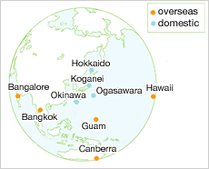
Location map of monitoring stations

We are setting up monitoring stations under international collaboration. If you want to make good use of a satellite, you need to thoroughly understand the state of its performance and location. It is also very important to observe a satellite from different directions in order to better calculate its orbit, so for QZSS, four monitoring stations will be set up in Japan - in Hokkaido, Koganei, Ogasawara, and Okinawa - and there will be five stations overseas, in Bangalore (India), Hawaii and Guam (U.S.), Bangkok (Thailand), and Canberra (Australia).
The QZSS is specifically designed to linger over Japan for a long time so we can maximize their benefit for the country. However, the satellites will appear over Korea almost as clearly as over Japan, and signals are also receivable in Australia and South-East Asia. As more or less the same positioning services can be provided in those countries, we are discussing joint technological applications.
Quasi-Zenith Satellite
Q. Why do you think that a satellite system like QZSS is so much in demand today?
Before car navigation systems and GPS mobile phones, people were not very interested in knowing precisely where they were. But as the significance of positioning information has been revealed, people have started to appreciate the available technology, and then began to ask for ever-better quality. It's like once you are exposed to high-definition TV, VHS can no longer satisfy you. GPS has become pretty common in our lives, but the existing services are not yet perfect. I think that's why a new, improved system is in demand right now.
Q. Are other countries involved in the QZSS project?
Location map of monitoring stations
We are setting up monitoring stations under international collaboration. If you want to make good use of a satellite, you need to thoroughly understand the state of its performance and location. It is also very important to observe a satellite from different directions in order to better calculate its orbit, so for QZSS, four monitoring stations will be set up in Japan - in Hokkaido, Koganei, Ogasawara, and Okinawa - and there will be five stations overseas, in Bangalore (India), Hawaii and Guam (U.S.), Bangkok (Thailand), and Canberra (Australia).
The QZSS is specifically designed to linger over Japan for a long time so we can maximize their benefit for the country. However, the satellites will appear over Korea almost as clearly as over Japan, and signals are also receivable in Australia and South-East Asia. As more or less the same positioning services can be provided in those countries, we are discussing joint technological applications.
Q. What is the ultimate goal of the QZSS?
It is to establish an environment that enables continuous positioning. You couldn't use mobile phones underground in the past, but strong demand grew for improvement, and now they are usable underground. Similarly, I'd like precise positioning information to become ubiquitous so people can precisely pinpoint their location no matter where they are. Neither GPS nor QZSS signals can reach inside buildings or underground. So we are trying to develop a system that allows acquisition of precise location information by placing devices at many points in buildings and underground that will release location information through a different method and receive common signals from satellites. The pilot program for this system has already started. I believe that establishing an environment to actualize seamless positioning is one of the major roles of the QZSS. I hope that the first satellite will be launched as planned, and that we get good results from it, and I would like to move on to provision of round-the-clock positioning services with the next three satellites.
Q. What do you most look forward to about the QZSS program?
In regards to navigation satellite systems, there are United States' GPS, Europe's Galileo, and Russia's GLONASS. India and China also have their own projects. With some exceptions, the systems each use a different signal, but there is a movement towards having universal signals in the future. To begin with, we are working on giving QZSS compatibility and interoperability with GPS signals. I anticipate seeing QZSS recognized as a star of regional positioning systems, and deployed on a global scale.
GPS consists of a constellation of 24 satellites, but the performance degrades when measuring amidst tall buildings or in valleys. Even though it is limited to the Asia-Pacific region, it will be possible for QZSS to provide better services thanks to enhancements and improvements to the GPS positioning ability. In the future, I'd like to expand a similar system to Africa and Europe.
Related Link: Quasi-Zenith Satellite System
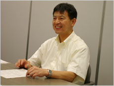
Koji Terada
Project Manger, Quasi-Zenith Satellite System, Space Applications Mission Directorate, JAXA
After graduating from the Department of Aerospace Engineering at the University of Tokyo in 1985, Mr. Terada participated in the development of the Engineering Test Satellite VI (Kiku No. 6), at the National Space Development Agency (now part of JAXA). He took responsibility for promoting applications of Earth observation satellites and the development of the Engineering Test Satellite VIII (Kiku No. 8). He was appointed to his current position in January 2007, when the QZSS project team was launched.