Q. Why does JAXA regard Asia as important?
JAXA's long-term vision includes a broad policy "to contribute to a safe and affluent society by utilizing aerospace technology." This means a policy to create and deploy space technology to solve local problems such as natural disasters.
Asian countries are our neighbors, and obviously we have very close ties with them on environmental issues such as climate change, and in terms of industrial and economical relations. To create a safe and secure society in all the Asian countries, cooperation is indispensable. For this purpose, there are two main pillars of Earth observation: the Disaster Management Support System and the Earth Environment Observation Prediction System.
Already, as a space pioneer in the Asian region, Japan has used data from the meteorological satellite Himawari to protect some 30 countries in the Asia-Pacific region from the effects of natural disasters. JAXA needs to continue to show leadership in space development in Asia. Japan's Basic Space Plan, which took effect in June, defines the promotion of space diplomacy as a national policy. Under this policy, JAXA will develop and utilize space systems and satellites, and develop deeper cooperation among Asian countries.
Q. What is APRSAF, and why was it founded?
APRSAF stands for the Asia-Pacific Regional Space Agency Forum, an international grouping of Asian space agencies to promote cooperation in space. In order to promote space utilization, we need cooperation not only from space agencies, but also from related government and business organizations in each Asian country. Representatives of such groups are also invited to the forum to discuss space technology and its utilization.
In 1992, the International Space Year, there was a meeting of space scientists and agencies in the Asia-Pacific region. There were many suggestions for a framework for Asian cooperation in space. Japan, which was taking the initiative in the Asian region for the International Space Year, spearheaded the founding of APRSAF in 1993. At that time, many Asian countries had only recently established their own space agencies, and were just starting to grapple with space development. APRSAF's aim was to link the Asia-Pacific nations, and to promote the development and utilization of space technology for peaceful purposes. To date 15 APRSAF prenary meetings have been held, at a pace of about one a year.
In 1992, the International Space Year, there was a meeting of space scientists and agencies in the Asia-Pacific region. There were many suggestions for a framework for Asian cooperation in space. Japan, which was taking the initiative in the Asian region for the International Space Year, spearheaded the founding of APRSAF in 1993. At that time, many Asian countries had only recently established their own space agencies, and were just starting to grapple with space development. APRSAF's aim was to link the Asia-Pacific nations, and to promote the development and utilization of space technology for peaceful purposes. To date 15 APRSAF prenary meetings have been held, at a pace of about one a year.
Q. Has the number of APRSAF members increased over the past 15 years? Have the attitudes of members toward space development and utilization changed?
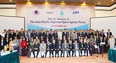
15th Asia-Pacific Regional Space Agency Forum (APRSAF-15), held in Vietnam. (Courtesy of APRSAF)
APRSAF meetings are organized independently by each host, so there are no fixed participants like at the United Nations, nor a membership system. We invite major related organizations and industries rather than just space agencies, so the number of participants is steadily increasing. More than 200 participants from 20 countries attended APRSAF-15, held in Vietnam last December. Lately we've also been inviting politicians and related organizations that are interested in international cooperation in Asia, so that we can gain a higher level understanding and more support for our efforts in Asia through space. In this sense, APRSAF is becoming more and more active.
The awareness of participants has been changing as well. Needless to say, expectations for space technology to solve local problems are growing. More people are realizing the merits of space utilization, now that images from Earth observation satellites provided by the Sentinel Asia system are being used in disaster management. Organizations that have seen tangible benefits from space utilization actively participate in APRSAF.
For the first 10 years of APRSAF, the main activity was information exchange among space engineers from participating countries, and we certainly gained some good results for the use of space. But starting around 2003, we decided to target specific achievements in space utilization through cooperation among Asian space agencies. APRSAF activities became more project-oriented. In 2006, we established the international project Sentinel Asia, to monitor natural disasters in the Asia-Pacific region. As a result of this change in direction, I think the participants have come to expect more tangible results.
Q. What kind of things do other APRSAF participating countries expect from Japan?
Japan is naturally expected to lead the field in disaster monitoring. Since we have the most advanced Earth observation satellites, such as DAICHI (ALOS), I think expectations are very high for our cooperation in disaster monitoring, including emergency observation and data distribution at the time of disasters. Secondly, Japan has met the increasing demand for environmental monitoring with the launch of the Greenhouse Gases Observing Satellite IBUKI (GOSAT) last January. In addition, there are needs in space technology, specifically for other countries to have their own small satellites, and requests for us to train their engineers.
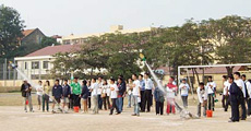
APRSAF-15 Water Rocket Competition in Vietnam (Courtesy of APRSAF)
Q. What do you think is APRSAF's greatest achievement so far?
Sentinel Asia may be our most successful achievement to date. This is only the third year since the start of the project, but it is already being used regularly by disaster management organizations across Asia, and is also recognized overseas.
The main role of Sentinel Asia is to perform emergency satellite observations when a natural disaster strikes, and to provide data from these observations to help assess the situation and take necessary measures. To date, 50 emergency observations have been performed. For example, in May 2008, when a major earthquake struck Sichuan province in China, Japan provided the first satellite data of the devastated area. Other recent natural disasters have included an eruption of Mt. Merapi in Indonesia, an earthquake in Jakarta, and a flood in Myanmar. Images from the Advanced Land Observing Satellite DAICHI (ALOS) have been provided to Indonesia, Thailand, the Philippines, Vietnam, Myanmar, India and Bangladesh, as well as the South Pacific island of Samoa.
In addition, the educational sector of APRSAF has enthusiastically put on space education activities for children in Asia, through events such as the water rocketcompetition. APRSAF has been fostering the dreams of children who will carry the future of Asia.
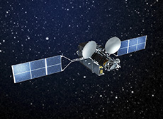
Wideband InterNetworking engineering and Demonstration Satellite KIZUNA (WINDS)
Q. How will Sentinel Asia be enhanced in the future?
Sentinel Asia is being developed in three phases. The first, a disaster-information-sharing system using the Internet, was completed in 2006 and 2007. The system uses primarily the Japanese Earth observation satellite DAICHI (ALOS), as well an Indian satellite. In the second step, started in January 2008, the main goals are: 1) to increase the number of participating satellites; 2) to improve data accessibility; 3) to provide value-added information such as analytical images; and 4) to increase the types of natural disaster to be monitored.
In the first phase, a working group was established to monitor floods and forest fires; in the second phase, we added observations of the increase in the number of glacial lakes. In recent years, glaciers have been melting due to the effects of global warming, and sometimes glacier-fed lakes flood surrounding areas. So these observations will help prevent damage from floods. In addition, we would like to use JAXA's ultra high-speed Internet satellite KIZUNA (WINDS) to provide data at high speed even in areas where Internet infrastructure is not well established. In addition, as international cooperation expands, we plan to add the Thailand Earth Observation Satellite (THEOS) and the Korea Multi-Purpose Satellite (KOMPSAT) to the Sentinel Asia project.
China is also considering participating in Sentinel Asia and providing data from its own satellites. To date, Sentinel Asia has provided China with timely disaster data, as well as sharing observation data on the distribution of water in Asia. Research-level cooperation has also been growing. So I think there is a possibility that the circle of cooperation will be extended to China in the Earth observation and space science fields.
The third phase, scheduled to start after 2010, will put the Sentinel Asia on more routine operations and expand the utilization of Sentinel Asia. So far, the system has been used only when specific disasters strike; in this third phase, we aim to operate it on more continuous basis. At present, the Asian Disaster Reduction Center (ADRC) acts as a contact office for emergency observations on an ad hoc basis; in future, we would like to set up a dedicated office for Sentinel Asia data, operated by the participating organizations.