Quasi-Zenith Satellite System (QZSS) watching Japan from above
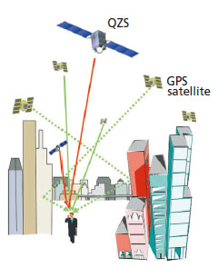 As mobile phones equipped with car navigation or GPS (*1) have become widespread, positioning information using satellites is imperative to our lives. However, in some urban or mountainous areas, positioning signals from a satellite are often hampered by skyscrapers or mountains, or significant errors are caused by reflection waves, thus we sometimes lose our way. The first Quasi-Zenith Satellite "MICHIBIKI" will contribute to solving such problems.
The QZSS consists of a multiple number of satellites that fly in the orbit passing through the zenith (just above) over Japan. With this system, at least one of the satellites is deployed over Japan permanently. By placing the satellite always at the near zenith of Japan to additionally provide signals from the QZSS, we can expand the areas and time duration of the positioning service provision in mountainous and urban regions where radio waves from a GPS satellite cannot find the necessary number of satellites for positioning (*2).
The MICHIBIKI is the first satellite of the Quasi-Zenith Satellite System to carry out verification for technological aspects and utilization in order to complement and reinforce the GPS.
*1: GPS is a Global Positioning System, which is a positioning system comprised of about 30 GPS satellites. The system was developed by the U.S.
*2: For positioning, it is necessary to receive positioning signals from four or more satellites.
You can receive accurate positioning information anywhere in Japan
In places such as urban valleys and mountainous areas where the number of communicable satellites is limited, we will be able to receive more accurate positioning information by combining the GPS and the MICHIBIKI. In addition, the quasi-zenith positioning satellite is to transmit information that can improve accuracy and reliability of the GPS (*3).*3: A research and development agency affiliated to the Ministry of Land, Infrastructure, Transport and Tourism of Japan engages in R&D of information transmission for improving accuracy and reliability of the GPS
'Freshness' is critical for mapping
On May 30, 2007, the Basic Act on the Advancement of Utilizing Geospatial Information was enacted. It stipulates to make basic map information electronic and standardized for promoting practical use and application of the geospatial information service (GIS.) Due to the prevalent use of car navigation systems, "freshness" is critical for map information. If a quasi-zenith positioning satellite can expand the areas and time of the positioning service, it is expected to improve land survey and mapping accuracy with more frequently updated information. Such "fresh" map information will be useful for further expanding positioning services.Helpful in preventing crimes and traffic accidents
Availability and reliability are major challenges we face when we try to apply satellite positioning to fields that entail strict safety requirements (*4). A quasi-zenith positioning satellite plays an important role to encourage technological development that is applicable for enhancing the availability and reliability of the GPS.If we can overcome these challenges, satellite positioning will be more utilized in various areas including application for the Intelligent Transport Systems (ITS), tracking stolen cars, and preventing illegal waste disposal.
*4: Temporal ratio for acquiring signals from at least four satellites that are required for positioning, or for achieving designated positioning accuracy
Contribute to upgrading work efficiency in the agriculture, fishery, and construction fields
Satellite positioning technology is also applied to control construction and agricultural machinery. If a highly accurate positioning service is available all over Japan, it can be useful for the agriculture and fishery industries as well as for saving energy and improving work efficiency of construction work in mountainous areas.Configuration and onboard parts of MICHIBIKI
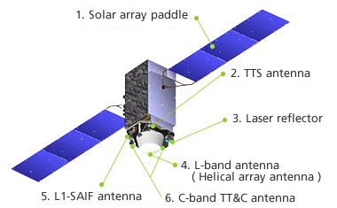
1. Solar Array Paddle
To transform sunlight to electric power to provide energy necessary for the satellite.
2. TTS Antenna
A transmission/receiving antenna for calibration tests on the onboard clock to conduct bidirectional time comparison with the ground.
3. Laser Reflector
To carry out laser ranging for verifying orbit and clock estimations and model improvements using L-band ranging signals.
4. L-band Antenna (Helical Array Antenna)
Transmitting five positioning signals including satellite position and time on four frequency bandwidths.
5. L1-SAIF Antenna
An antenna for reinforcing positioning signals to realize positioning accuracy of one meter.
6. C-band TT&C Antenna
Receiving correction data from the Okinawa tracking and communication station. It will also be used for transmitting and receiving signals for controlling the satellite.
Major Characteristics
| Shape | 2 box shape with wing-type solar array paddles 2.9m in depth x 3.1m in width x 6.2m in height (Length between the tips of the paddles: 25.3 m) |
|---|---|
| Weight | Approx. 4000kg |
| Orbiter | Quasi-Zenith Orbit |
| Altitude | Apogee: approx. 32,000 km, Perigee: approx. 40,000 km |
| Inclination | Approx. 40 degrees (Fluctuating between 39 and 47 degrees; 41 degrees in the initial phase.) |
| Period | 23 hours 56 minutes |