Image data acquired by the PRISM onboard the "Daichi"
Japan Aerospace Exploration Agency (JAXA)
The Japan Aerospace Exploration Agency (JAXA) would like to announce that image data was successfully acquired by the Panchromatic Remote-sensing Instrument for Stereo Mapping (PRISM) onboard the Advanced Land Observing Satellite "Daichi," which was launched on January 24, 2006 (Japan Standard Time, JST). The data was acquired as part of the initial functional verification test.
The attached images of Mt. Fuji (Diagram 1) and Shimizu Port in Shizuoka Prefecture (Diagram 2) were both observed by the PRISM at 10:30 a.m. on Feb. 14 (JST), and later received at the Earth Observation Center (in Hatoyama-cho, Hiki-gun, Saitama Pref.)
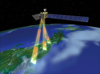
This sensor can acquire high-resolution three directional 3-D data, marking a world first for an earth observation satellite data.
We will release more image acquisitions by the Advanced Visible and Near Infrared Radiometer type 2 (AVNIR-2) and the Phased Array type L-band Synthetic Aperture Rader (PALSAR) as soon as they are performed.
|
|
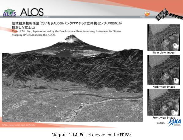
The image data of Mt. Fuji was observed by the Panchromatic Remote-sensing Instrument for Stereo Mapping (PRISM) onboard the Advanced Land Observing Satellite "Daichi" during the daytime (around 10:30 a.m.) on Feb. 14, 2006 (JST). The height of the mountain was calculated based on backward, nadir and foward view images shown on the right, then the bird's-eye picture was compiled by overlapping the nadir view image. You can see detailed streets and rivers in the Kofu Basin in the front in the image, Motosu Lake in the center right, and Fuji-Subaru Road that leads to the snow capped top of Mt. Fuji from Motosu Lake. The height is indicated twice as much in this bird's-eye picture.
A three-dimensional movie compiled from observed images [MPEG 3.6MB]
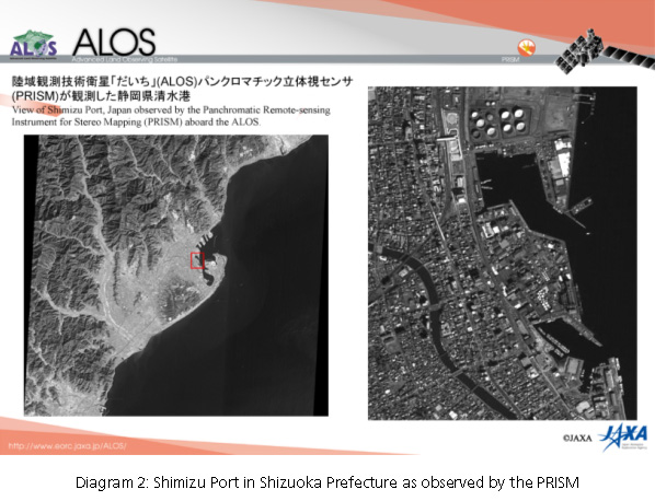
The image data of Shimizu Port near Shizuoka city was observed by the Panchromatic Remote-sensing Instrument for Stereo Mapping (PRISM) onboard the Advanced Land Observing Satellite "Daichi" during the daytime (around 10:30 a.m.) on Feb. 14, 2006 (JST). The area of Shimizu Port was enlarged (right) from the nadir view image on the left. In the image taken by the PRISM, whose spatial resolution is 2.5 meters, we can see ships at the port, boats in the yacht harbor, cars on the roads, Shimizu station on the JR Tokai Railway line, and houses.
Note: Spatial resolution indicates the physical size of an object that can be distinguished in an image.
 |
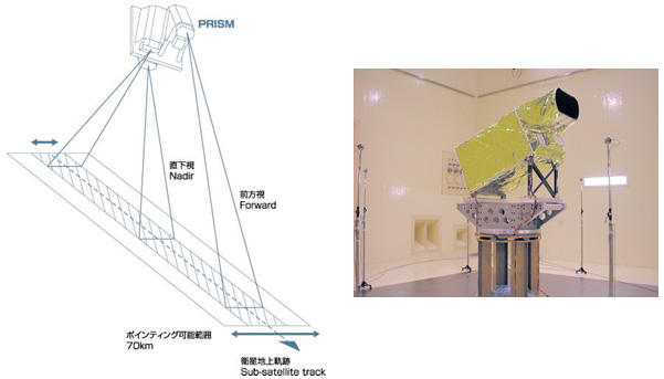
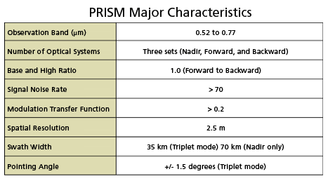
The PRISM is an optical sensor for observing visible terrain areas with a 2.5-meter spatial resolution. It has three independent optical systems to acquire terrain data including altitude data so that images for nadir, forward, and backward views can be acquired at the same time. This enables us to get three-dimensional terrain data with a high accuracy and frequency. |
 |
|
 |
|
For inquiries:
JAXA Earth Observation Research and Application Center:
Tel: + 81-3-6221-9008
Fax: +81-3-6221-9191