Providing Images of Leyte Island Observed by
the PALSAR onboard the "Daichi"
Japan Aerospace Exploration Agency (JAXA)
The Japan Aerospace Exploration Agency (JAXA) acquired images of Leyte Island in the Republic of the Philippines, where a huge landslide occurred on February 17, by the Phased Array type L-band Synthetic Aperture Radar (PALSAR) onboard the Advanced Land Observing Satellite "Daichi." After being analyzed by JAXA, images have been provided to the following organizations.
International Charter "Space and Major Disasters" *1
Asian Disaster Reduction Center (ADRC) *2
The images were observed and taken by the PALSAR around 10:50 a.m. on February 24 (Japan Standard Time, JST) as part of the initial functional test for the "Daichi." The images and their explanations are in Attachment-1.
*1 International Charter "Space and Major Disasters": Please refer to Attachment-2.
*2 Asian Disaster Reduction Center (ADRC): The ADRC was established in 1998 in Kobe, Japan, as a key organization to promote multilateral cooperation for disaster preparation at regional levels in Asia. It engages in information exchange among disaster experts from each country's relevant organization(s), as well as information gathering and provision, investigation and research on multilateral cooperation for disaster preparation/resection. The images JAXA provided this time will be offered to the local disaster reduction organization in the Philippines through the ADRC.
(ADRC URL: http://www.adrc.or.jp/top.php)
|
|
Figures 1 and 2 are comparison analyses of the image taken by the PALSAR* aboard the "Daichi" and that by the Synthetic Aperture Radar (SAR) aboard the Japan Earth Resources Satellite-1 "Fuyo-1" (JERS-1). The former was acquired on February 24, 2006, when the Daichi moved toward the south on the east side of Leyte Island after the landslide occurred, and the latter was taken on Feb. 2, 1996.
* The PALSAR is developed by the Ministry of Economy, Trade, and Industry (METI) in cooperation with JAXA.
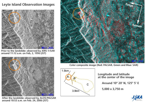
Figure 1: Leyte Island Observation Images
As the two radars used for the analyses, the PALSAR of the Daichi and the SAR of the Fuyo-1, share almost the same characteristics (such as radio frequencies), as well as the incident angles being almost the same, we can study the difference before and after the crisis by overlapping the images in a relatively simple way (Figure 1.) For underscoring the difference, the image taken by the Fuyo-1 on the top left is colored with blue and green, and the one taken by the Daichi on the bottom left with red to make a color composite image (on the right.) By doing so, we can confirm the geographic change in mountainous area and difference of brightness in the flatland. The brighter the area has become, the redder they are in the image.
In the color composite image on the right in Figure 1, a red area expands about 1.5 km in width and 3.9 km in length from the tip of the mountain circled by red to the south east. The red color is stronger in the slope (B area), and that can be explained by some parts of the slope having been eroded by the landslide and they faced directly to the satellite. From this finding, we can say that there are at least three huge slides on the slope.
Some parts in the flatland (C area) are brighter because of stronger radio wave reflection as mud in the landslide contains a great deal of water.
In the red circled mountain top (A area), it seems that the top part slid to the direction of the radar radiation. This is due to the characteristics of image processing, and based on the amount of sliding in the image and the incident angle (37 degrees), it can be interpreted that a slide of about 100 meters occurred.
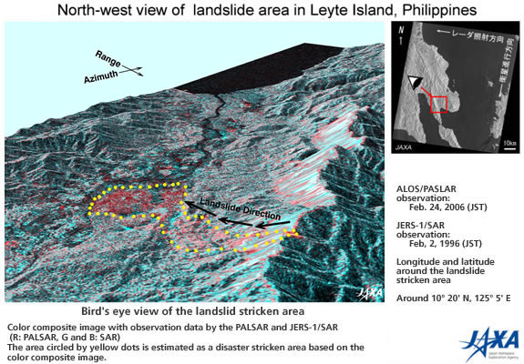
Figure 2: Layte Island Observed from the North-west Side
Figure 2 is a bird's-eye view of those changes explained above observed from the north east. The height information was acquired from the global altitude data with a 90-meter resolution that was compiled by the cooperative analysis of each country based on data observed by the Space Shuttle Endeavour mission which Astronaut Mori of JAXA participated in.
In Figure 2, you can see the smooth area on the slope on the east side of the rigid line on the right-hand side of the image, but it was created due to the relative position between the inclination angle of the radar wave and the slope, thus it does not indicate the landslide.
International Charter "Space and Major Disasters"
(1) Official Name
Charter on Cooperation to Achieve the Coordinated Use of Space Facilities in the Event of Natural or Technological Disasters
(2) Member Organizations and Satellites in Use
| Member Organizations | Satellite in Use |
|---|---|
| European Space Agency (ESA) | ERS, ENVISAT |
| French Space Agency (CNES) | SPOT |
| Canadian Space Agency (CSA) | RADARSAT |
| Indian Space Research Organization (ISRO) | IRS |
| National Oceanic and Atmospheric Administration (NOAA), United States Geological Survey (USGS) |
POES, GOES, LANDSAT |
| Argentine Space Agency (CONAE) | SAC-C |
| BritishNationalSpaceCenter (BNSC) | DMC (Disaster Monitoring Constellation) |
| Japan Aerospace Exploration Agency (JAXA) | ALOS (After starting its regular operation) |
(3) Objective
The International Charter established in 2002 is a framework to promote contributions from each space organization to help disaster stricken areas by providing data acquired by earth observation satellites for free based on the best efforts of the member organizations.
(4) Cooperative Structure
- Organized by member organizations and disaster related organizations.
- No financial exchange takes place among participating organizations.
- Activities are coordinated by the committee of representatives from each organization and the secretariat of the International Charter.
Provision of image data acquired by the "Daichi" is supposed to begin when its regular operation starts. Therefore, this time JAXA voluntarily provided the images acquired during the initial functional verification, although we did not receive an official request for observation from the Charter Secretariat.
International Charter URL: http://www.disasterscharter.org/main_e.html
For inquiries:
A Earth Observation Research and Application Center (EORC)
Tel: +81-3-6221-9008
Fax: +81-3-6221-9191