Mount Merapi (Java, Indonesia) Observed by
the Advanced Land Observing Satellite "Daichi"
Japan Aerospace Exploration Agency (JAXA)
The Japan Aerospace Exploration Agency (JAXA) received information from the International Charter "Space and Major Disasters" (*) that Mount Merapi, Java, in the Republic of Indonesia (a 2,968 meter high mountain) showed signs of volcanic activity. The mountain was observed on April 29, 2006 (Japan Standard Time, JST) using two onboard sensors of the Advanced Land Observing Satellite "Daichi" (ALOS), the Advanced Visible and Near Infrared Radiometer type 2 (AVNIR-2) and the Phased Array type L-band Synthetic Aperture Radar (PALSAR), to provide observation data to the Charter.
This is the first time in the world to observe the same area using a satellite onboard optical sensor and aperture radar simultaneously, and that enabled us to identify the characteristics of the area with higher precision.
For observed data, please see the attached (Attachement-1.)
* International Charter "Space and Major Disasters": Please refer to Attachement-2.
|
|
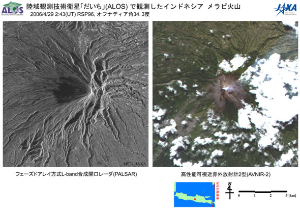
Mount Merapi at 11:40 a.m. on April 29, 2006 (JST)
The above images were taken by the Advanced Visible and Near Infrared Radiometer type 2 (AVNIR-2) (right) and the Phased Array type L-band Synthetic Aperture Radar (PALSAR) (left) at 11:40 a.m. on April 29, 2006 (Japan Standard Time, JST.)
According to the Directorate of Volcanology and Geological Hazard Mitigation, Indonesia (DVGHM), the crater cracked, and volcanic fumes were rising about 100 meters high from the crater on April 11. The AVNIR-2 observation data (right) clearly shows the fumes as well as volcanic ash at the crater and its surrounding area.
The PALSAR data (left) also clearly shows the undulating geographical character as radar reflection spreading radially from the crater to the foot of the mountain. The west side of the crater (on the left side of the crater in the image) is dark meaning weaker radar reflection, and that is considered to indicate different characteristics of the land surface.
Mount Merapi was named by combining the words "merah" (meaning "red") and "api" (meaning "fire"), and it is one of the most active volcanoes in Indonesia. There was a massive eruption in 1969 and it has repeatedly erupted once every two to three years since 1992. Every time lava erupts from the crater, it causes frequent damage including a collapse of a lava dome and destruction from a pyroclastic flow or a landslide.
International Charter "Space and Major Disasters"
(1) Official Name
Charter on Cooperation to Achieve the Coordinated Use of Space Facilities in the Event of Natural or Technological Disasters
(2) Member Organizations and Satellites in Use
| Member Organizations | Satellite in Use |
|---|---|
| European Space Agency (ESA) | ERS, ENVISAT |
| French Space Agency (CNES) | SPOT |
| Canadian Space Agency (CSA) | RADARSAT |
| Indian Space Research Organization (ISRO) | IRS |
| National Oceanic and Atmospheric Administration (NOAA), United States Geological Survey (USGS) |
POES, GOES, LANDSAT |
| Argentine Space Agency (CONAE) | SAC-C |
| BritishNationalSpaceCenter (BNSC) | DMC (Disaster Monitoring Constellation) |
| Japan Aerospace Exploration Agency (JAXA) | ALOS (After starting its regular operation) |
(3) Objective
The International Charter established in 2002 is a framework to promote contributions from each space organization to help disaster stricken areas by providing data acquired by earth observation satellites for free based on the best efforts of the member organizations.
(4) Cooperative Structure
- Organized by member organizations and disaster related organizations.
- No financial exchange takes place among participating organizations.
- Activities are coordinated by the committee of representatives from each organization and the secretariat of the International Charter.
Provision of image data acquired by the "Daichi" is supposed to begin when its regular operation starts. Therefore, this time JAXA voluntarily provided the images acquired during the initial functional verification, although we did not receive an official request for observation from the Charter Secretariat.
International Charter URL: http://www.disasterscharter.org/main_e.html
For inquiries:
JAXA Earth Observation Research and Application Center
Tel: + 81-3-6221-9085, 9136
Fax: +81-3-6221-9180