Mount Merapi (Java, Indonesia) Observed by
the Advanced Land Observing Satellite "Daichi" (Report #2)
Japan Aerospace Exploration Agency (JAXA)
On May 16, 2006, (Japan Standard Time, all times and dates in this report are Japan Standard Time), the Japan Aerospace Exploration Agency (JAXA) observed Mount Merapi, Java, in the Republic of Indonesia (a 2,968 meter high volcano,) which had been showing signs of volcanic activity, by using two onboard sensors of the Advanced Land Observing Satellite "Daichi", the Advanced Visible and Near Infrared Radiometer type 2 (AVNIR-2) and the Phased Array type L-band Synthetic Aperture Radar (PALSAR). Acquired image data was then provided to the International Charter "Space and Major Disaster" *1 and the National Institute of Aeronautics and Space of Indonesia (LAPAN) *2.
The observation this time was the second observation of Mount Merapi following the first one on April 29.
The image data is attached below.
*1: The International Charter "Space and Major Disaster": please refer to the reference bellow.
*2: The National Institute of Aeronautics and Space of Indonesia (LAPAN): please refer to the reference below.
|
|
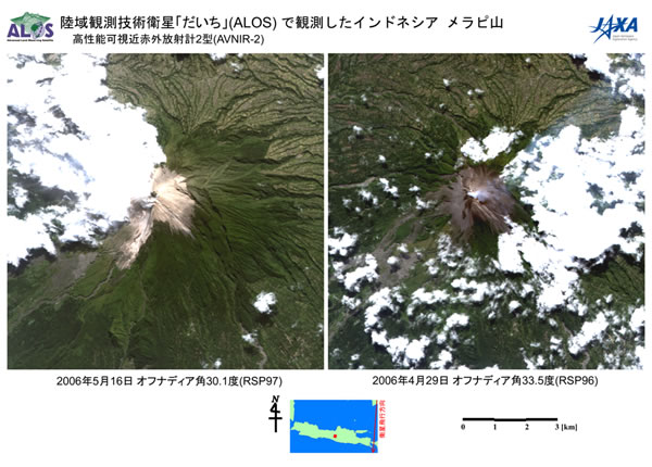
Figure 1
Figure 1 is observation data on Mount Merapi acquired by the Advanced Visible and Near Infrared Radiometer type 2 (AVNIR-2) at 11:45 a.m. on May 16, 2006 (left) and at 11:40 a.m. on April 29, 2006 (right.)
According to the Directorate of Volcanology and Geological Hazard Mitigation (DVGHM), Indonesia, the lava dome near the crater has become bigger, and a pyroclastic flow has been generated. In the image data taken by the AVNIR-2 today (upper left), we can see that the whitish area covered by volcanic ash that was not observed in the previously acquired data has been expanding, and traces of a pyroclastic flow are also observed on the south west side of the crater. Also, near the crater, a black part indicates the lava dome.
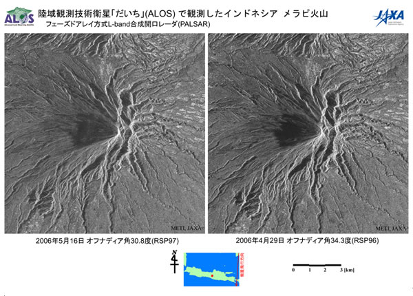
Figure 2
Figure 2 is observation data on Mount Merapi acquired by the Phased Array type L-band Synthetic Aperture Radar (PALSAR) at 11:45 a.m. on May 16, 2006 (left) and at 11:40 a.m. on April 29, 2006 (right)
The PALSAR data this time (left) did not show a clear geographic difference compared to the previous data, although there is a difference in shading due to the different observation angles (the angle against the observation point was 30 degrees last time while it was 34 degrees this time.)
International Charter "Space and Major Disasters"
(1) Official Name
Charter on Cooperation to Achieve the Coordinated Use of Space Facilities in the Event of Natural or Technological Disasters
(2) Member Organizations and Satellites in Use
| Member Organizations | Satellite in Use |
|---|---|
| European Space Agency (ESA) | ERS, ENVISAT |
| French Space Agency (CNES) | SPOT |
| Canadian Space Agency (CSA) | RADARSAT |
| Indian Space Research Organization (ISRO) | IRS |
| National Oceanic and Atmospheric Administration (NOAA), United States Geological Survey (USGS) |
POES, GOES, LANDSAT |
| Argentine Space Agency (CONAE) | SAC-C |
| BritishNationalSpaceCenter (BNSC) | DMC (Disaster Monitoring Constellation) |
| Japan Aerospace Exploration Agency (JAXA) | ALOS (After starting its regular operation) |
(3) Objective
The International Charter established in 2002 is a framework to promote contributions from each space organization to help disaster stricken areas by providing data acquired by earth observation satellites for free based on the best efforts of the member organizations.
(4) Cooperative Structure
- Organized by member organizations and disaster related organizations.
- No financial exchange takes place among participating organizations.
- Activities are coordinated by the committee of representatives from each organization and the secretariat of the International Charter.
Provision of image data acquired by the "Daichi" is supposed to begin when its regular operation starts. Therefore, this time JAXA voluntarily provided the images acquired during the initial calibration and verification, although we did not receive an official request for observation from the Charter Secretariat.
International Charter URL: http://www.disasterscharter.org/main_e.html
National Institute of Aeronautics and Space of Indonesia (LAPAN)
JAXA and LAPAN have been promoting the pilot project for verification and utilization of observation data acquired by the "Daichi" (ALOS) since Japan Fiscal Year 2005. JAXA provides "Daichi" observation data to LAPAN, and LAPAN is scheduled to verify the usefulness of the data in corporation with the Indonesian Government.
For inquiries:
Japan Aerospace Exploration Agency
Satellite Applications and Promotion Center
Disaster Management Support Office (DMSO)
TEL: + 81-3-6221-9011, 9012
FAX: +81-3-6221-9191