Start of "ALOS Kyoto & Carbon Initiative"
by the Advanced Land Observing Satellite "Daichi"
Japan Aerospace Exploration Agency (JAXA)
The Japan Aerospace Exploration Agency (JAXA) has been working on the establishment of the "ALOS Kyoto & Carbon Initiative"*1 since 2003. The Initiative is being carried out as cooperative research with 20 international research institutions including the University of California Santa Barbara (UCSB,) USA. On August 23, 2007, we finalized the conclusion of the agreements with all 20 international research institutions following the signing of Brazilian Institute of Environment and Renewable Resources (IBAMA.) With the completion, we began our full-scale operation of the project on September 3.
JAXA and IBAMA will specify the area of deforestation including illegal activities using images acquired by the onboard equipment "PALSAR"*2 of the "Daichi."
Figure 1 is an example image that will be provided to the IBAMA without a time lag. Figure 2 is a clip (10 km x 10 km area) of the image. Figure 3 is a high resolution mosaic image (combination of several scenes) of the Londonia region of the Amazon. An image like Figure 3 is being created within three months after receiving images from around a continent.
*1: ALOS Kyoto & Carbon Initiative
The purpose of this project is to study the relationship between changes in the global environment and changes in forests, their surrounding areas, swamplands and deserts, which account for about 30% of the global land area, by observing their long-term and seasonal changes in a broad scope through the onboard synthetic aperture radar of the "Daichi." The study is based on the analysis of the observation data as well as a site survey. For this purpose, JAXA will carry out global observations including on tropical rain forests in South America (Amazon,) Southeast Asia, and Central Africa, and the boreal forests in Siberia, Canada, and Alaska. Acquired data will be transmitted to each institution via exclusive online networks within three months after it is received at the Earth Observation Center (Hatoyama-machi, Saitama) of JAXA. In the case of data from the Amazon area, it is converted to images immediately, and provided to the IBAMA within 10 days.
JAXA reference URL: http://www.eorc.jaxa.jp/ALOS/kyoto/jun2007_kc8/kyoto_meeting_2007jun.htm
(Participated research institutions in no particular order)
The University of Wales (UK), Borneo Orangutan Survival Foundation (Indonesia), Centre de Etudes Spatiales de la Bisphere (France), German Aerospace Center (Germany), Friedrich-Schiller University Jena, Institute of Geography (Germany), National Institute for Space Research (Brazil), University of Massachusetts (USA), Joint Research Center of the European Commission (EU), University of Boudreaux (France), Sarmap (Switzerland), Swedish University of Agricultural Sciences (Sweden), University of California Santa Barbara (USA), Horizon Geoscience Consulting pty Ltd. (Australia), University of Victoria (School of Earth and Ocean Science) (Canada), University of Victoria (Department of Geography) (Canada), Wetland International (Netherlands), Applied Geosolutions, LLC (USA), Helsinki University of Technology (Finland), Sheffield Center for Terrestrial Carbon Dynamics (UK), Brazilian Institute of Environment and Renewable Resources (Brazil)
*2 PALSAR
The Phased Array type L-band Synthetic Aperture Radar (PALSAR), is a microwave sensor receiving radio wave reflections transmitted from the satellite. It can acquire image data regardless of the weather and time of day. One of the characteristics of the L-band microwave is that it can partially penetrate through a forest to the ground; therefore, it is suitable to observe a lower part of a forest.
|
|
Deforestation in Brazil (Mato Grosso)

Blackened areas indicate deforestation.
Figure 2 Clip of the above photo (10 km x 10 km area)
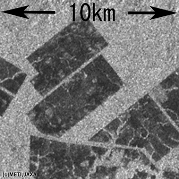
Figure 3 High-resolution Amazon mosaic image
(420 km x 420 km area)
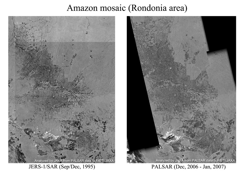
When comparing the current image (right) and the 11 year old image (left,)
you can see that the darkened areas (deforestation sites) have been extended.