KAGUYA (SELENE)
Image Taking of "Full Earth-Rise" by HDTV
Japan Aerospace Exploration Agency (JAXA)
Japan Broadcasting Corporation (NHK)
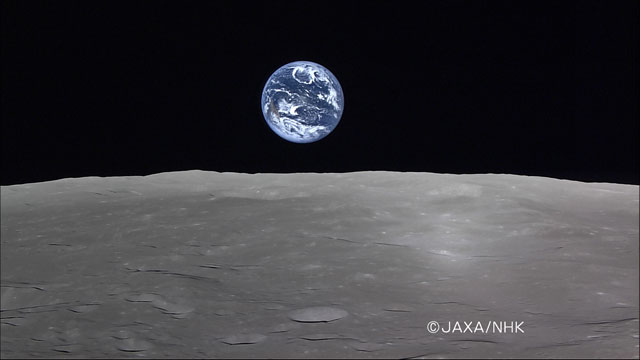
The Japan Aerospace Exploration Agency (JAXA) and NHK (Japan Broadcasting Corporation) successfully captured a movie of the "Full Earth-Rise"*1 using the onboard High Definition Television (HDTV) of the lunar explorer "KAGUYA " (SELENE) on April 6, 2008 (Japan Standard Time, JST, all the following dates and time are JST.) The KAGUYA is currently flying in a lunar orbit at an altitude of about 100 km.
An "Earth-rise," or the rising Earth over the Moon, was first captured by the Apollo project. The Earth rising image taken by the KAGUYA on November 7, 2007, was not a full Earth-rise (i.e. not all of the globe was seen in shining blue.) It missed some part. This time, a "full Earth-rise"*1 was taken by the onboard HDTV in faraway space, some 380,000 km away from the Earth. This is the world's first successful shooting of such a Full Earth-Rise. It was also very precious because it was one of only two chances in a year for the KAGUYA to capture a Full Earth-Rise when the orbits of the Moon, the Earth, the Sun and the KAGUYA are all lined up.
The shooting was performed by the KAGUYA's onboard HDTV for space use, which was developed by NHK. The movie data was received at JAXA, then processed by NHK.
*1 The phenomenon expressed as a "Full Earth-Rise" can be seen from a satellite that travels around the Moon such as the KAGUYA (SELENE) or the Apollo manned spacecraft. The Earth is almost stationary when it is observed from the Moon, thus a Full Earth-Rise coming out from the horizon cannot be seen from the Moon.
Full Earth-rise taken by HDTV (Tele camera)

The location on the Moon is around the South Pole on the back side at a south latitude of 83 degrees or higher. You can see the North American Continent on the image of the earth on the lower left and Pacific Ocean in the center. (The top of the image is the south of the Earth, thus the North American Continent is seen upside down.)
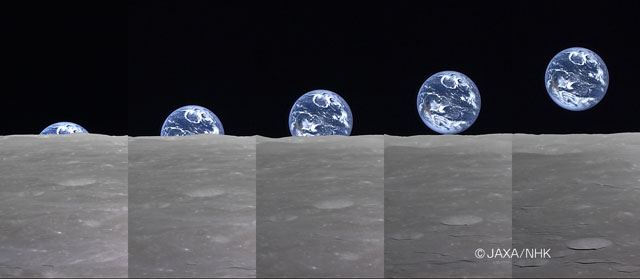
The image below shows the Earth rising from the Moon's horizon. It took about 40 seconds from the left image to the right.

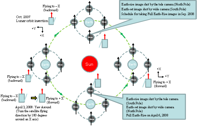
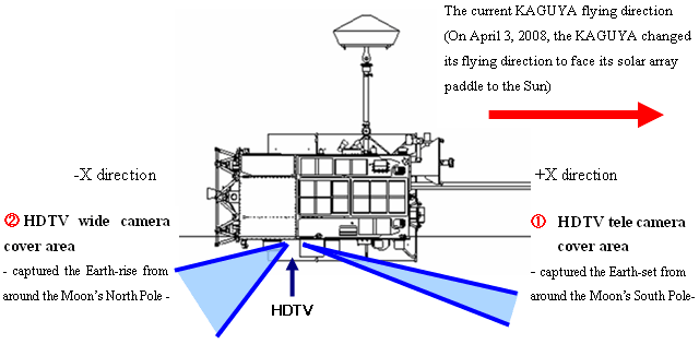
The above figure shows the relative positions of the Sun, Earth, Moon and the KAGUYA by setting the Sun at the center viewing from the North. Black arrows indicate the KAGUYA's orbit around the Moon, and red arrows are the KAGUYA's moving direction. The green arrows show the Earth's revolving direction around the Sun. "Yaw around" is an attitude control maneuver to change the KAGUYA's moving direction by using its thruster for attitude control to face the solar array paddle toward the Sun. On April 3, we performed the yaw around, and the KAGUYA is now flying toward +X direction (forward direction,) which is 180 degrees around the original direction when the KAGUYA was launched (-X direction or backward direction.) Through the yaw around maneuver, the HDTV tele camera faces toward the moving direction.

Figure 2: Position of HDTV
|
|
| Location | Start of image shooting (JST) |
Completion of image shooting | Starting location | Finishing location |
| Plateau | at 4:41 p.m. on Feb. 25 | 4:49 p.m. | N lat. 78 deg. E long. around 339 to 5 deg. |
N lat. 54 deg. E long. around 347 to 355 deg. |
| Pythagoras | 2: 56 p.m. on Feb. 29 | 3:04 p.m. | N lat. 81 deg. E long. around 279 to 315 |
N lat. 57 deg. E long. around 294 to 303 deg. |
| Mare Humboldtianum | 7:33 p.m. on March 16 | 7:41 p.m. | N lat. 75 deg. E long. around 73 to 93 deg. |
N lat. 51 deg. E long. around 88 to 89 deg. |
| Mare Serenitatis (Sea of Serenity) South area |
9:13 a.m. on March 22 | 9:21 a.m. | N lat. 19 deg. E long. around 10 to 16 deg. |
S lat. 5 deg. E long. around 9 to 15 deg. |
| Full Earth-set | 12:15 p.m. on April 5 | 12:19 p.m. | N lat. 86 to 87 deg. E long. around 118 to 259 deg. |
N lat. 76 deg. E long. around 176 to 199 deg. |
| Full Earth-rise | 6:44 a.m. on April 6 | 6:45 a.m. | S lat. 82 to 83 deg. E long. around 152 to 194 deg. |
S lat. 85 to 86 deg. E long. around 134 to 209 deg. |
* The above images are all publicized in the JAXA Digital Archives.
| HDTV | |
|
CCD(1920×1080: valid pxcels) 3 chips Three primary colors spectrum by Dichroic Prism Fixed lenses (T: tele camera, W: wide camera) T: 51.23°(horizontal) 30.17°(vertical) W: 15.60°(horizontal) 8.80°(vertical) |
