SHIZUKU Observation Data Acquired by AMSR2
Japan Aerospace Exploration Agency (JAXA)
The Japan Aerospace Exploration Agency (JAXA) has released some observation images on the Earth acquired by the Global Change Observation Mission 1st - Water "SHIZUKU" (GCOM-W1). The SHIZUKU was launched from the Tanegashima Space Center at 1:39 a.m. on May 18, 2012 (Japan Standard Time) and entered into the A-train orbit on June 29, then has started regular observations since July 3, after increasing the antenna rotation of the onboard Advanced Microwave Scanning Radiometer 2 (AMSR2) to 40 rpm.
Figure 1 is a one-full-day observation image of the Earth by the AMSR2 aboard the SHIZUKU from 9:00 a.m. on July 3 (JST) to July 4. In this image, whitish-yellow color parts indicate areas with heavy rain or sea ice, light blue color areas are with little water vapor in the atmosphere or thin clouds, the dark blue color sections are areas with more water vapor in the atmosphere or thicker clouds, and the black color parts are areas that were not observed.
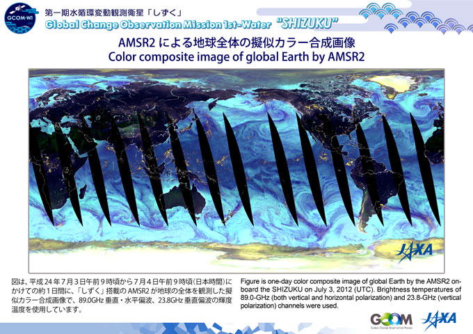
Figure 2 is a close-up view around Japan cut out from Figure 1. The SHIZUKU flew over Japan around 1:00 p.m. on July 3 (JST). At that time, a rain front remained over Japan, and the image shows whitish-yellow color parts, which indicate areas with heavy rain, over wide areas of the eastern part of Shikoku Island, and the Kinki and Tokai regions. Also, there was a low pressure system over the sea on the east of Japan, and the whirly pattern in light to dark blue colors corresponds to the distribution of water vapor and clouds in the atmosphere.
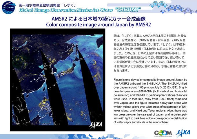
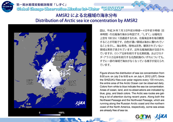
Figure 3 shows the distribution of sea ice concentration during July 3-4, 2012 (JST). Since the SHIZUKU flies over the Polar Regions many times (every 100 minutes) in a day, the entire area of the Arctic Ocean can be observed daily. In the image, white indicates areas covered by ocean ice, blue is sea areas, gray is land, and black areas were not observed. The Arctic sea routes are drawing a lot of attention in recent years. Through our observations we can see that we have already lost some sea ice in the ocean on both the Northeast Passage along the Russian Arctic coast and the Northwest Passage on the Canadian and Alaskan coasts.
http://www.jaxa.jp/countdown/f21/live/missionphoto_e.html
We will continue the initial functional verification (for about three months after launch,) then confirm data accuracy by comparing it with observation data acquired on land, and perform initial calibration and inspection operations including data correction.
|
|