Application of Data Acquired by SHIZUKU
at Japan Meteorological Agency
Japan Meteorological Agency (JMA)
Japan Aerospace Exploration Agency (JAXA)
Observation data by the Advanced Microwave Scanning Radiometer-2 (AMSR2) aboard the Global Change Observation Mission 1st - Water “SHIZUKU” (GCOM-W1) has been transmitted to the Japan Meteorological Agency (JMA) in near-real time. The SHIZUKU was launched by the Japan Aerospace Exploration Agency (JAXA) in May 2012. As data from the AMSR2 includes vapor and Sea Surface Temperature information in the atmosphere, JMA and JAXA cooperated to examine the best utilization of the acquired data, and advanced technological development for that purpose.
Consequently, we were able to confirm that precipitation forecast accuracy can be further improved in the numerical weather prediction system that compiles basic materials for weather forecasts, thus JMA started the data application on Sept. 12, 2013. The JMA also analyzes Sea Surface Temperatures across the Earth once a day, and AMSR2 data has also been used for that purpose from May 27, 2013, because the analysis quality has also been expected to improve.
JMA and JAXA are doing their best to develop a method to use valuable observation data from the satellite.
|
|
AMSR2 Data Application by JMA Numerical Weather Prediction System
The Japan Meteorological Agency (JMA) operates the numerical weather prediction (NWP)system for compiling basic materials for weather forecasting and issuing warnings and advisories. The NWP system predicts future weather conditions by dividing the Earth's atmosphere into small grids on a chart and allocating atmospheric values such as the wind, temperature and vapor volume in each grid to calculate time-lapsing changes based on physics rules. For the computations, it is imperative to fill in all grids with necessary numbers including wind and temperature values at the outset. Those initial values reproduce the actual atmospheric conditions at a specific time on the computer as accurately as possible, thus the accuracy of reproduction greatly affects forecast accuracy. Therefore, various meteorological observation data including that from satellites is used for compiling the initial values.
Among the meteorological satellite data utilized for compiling the initial values, water vapor distribution information over ocean around Japan can be obtained from the AMSR2. Such information has been obtained from the American satellite named “DMSP1” (16th, 17th, and 18th DMSPs) and the JAXA-NASA cooperative satellite mission called “TRMM2” satellite's Microwave Imager. However, due to their orbits, the DMSP flies over Japan only between 6:00 and 9:00 every morning and evening, and the observation hours of the TRMM vary every day. As a result, there was no microwave data regularly obtained in the afternoon hours and late evenings. The atmospheric vapor distribution changes from time to time. In that sense, forecast errors are becoming bigger due to such a lack of observation data. SHIZUKU's AMSR2 can cover such missing data and prevent errors from getting worse.
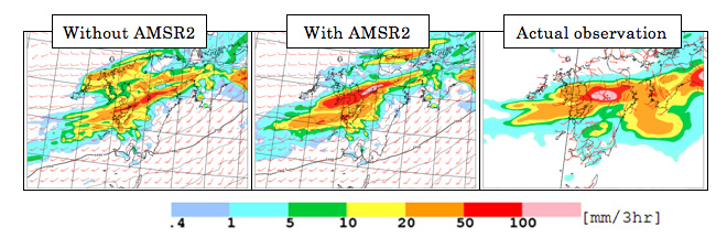
Figure 1.1 is an example to prove improvements in the precipitation prediction of the Meso Scale Model (MSM) of the JMA by using AMSR2 data. According to predictions based on the initial values of MSM at 9:00 a.m. on July 11, 2012 (Japan Standard Time, JST), prediction accuracy was not satisfactory (left in Figure 1.1.) This prediction was enhanced and improved by using the data from the AMSR2 (middle in Figure 1.1). AMSR2 data allowed more appropriate analysis of water vapor volume in the East China Sea in the upstream of Kyushu, and, as a result, precipitation prediction was improved.
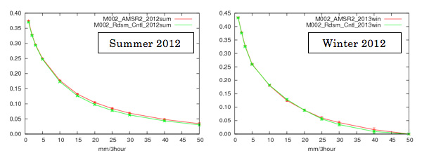
Figure 1.2 shows the statistic result of the equitable threat score of each precipitation strength in the AMSR2 application experiment (for one month in the summer and winter seasons) that was performed by the JMA prior to the practical use. The red line indicates the values with data from the AMSR2, and the green line is without them. As you can see, the red line is above the green line to become closer to 1*3 in almost all threshold values, thus it is clear that the precipitation prediction accuracy was improved.
As a result of the aforementioned, we can expect to improve the precipitation forecast accuracy by AMSR2 data; therefore, we decided to apply them in the JMA's NWP system from September 12, 2013.
1 DMSP: Defense Meteorological Satellite Program
2 TRMM: Tropical Rainfall Measuring Mission
3 Index indicates the hit rate of the precipitation forecast.
Application of AMSR2 data
to JMA Sea Surface Temperature Analysis
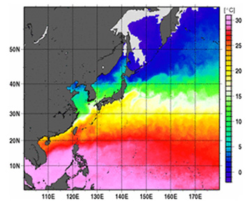
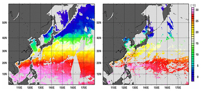
The Japan Meteorological Agency (JMA) analyzes Sea Surface Temperatures all over the Earth once a day using remote sensing data with a multiple number of satellites in addition to on-site observation by ships and buoys (Figure 2.1.) Remote sensing for Sea Surface Temperatures is performed by applying data acquired by radiation measurement equipment such as the AVHRR, an infrared radiometer aboard the America's NOAA satellite, and the AMSR2, a microwave radiometer of the SHIZUKU. The infrared radiometer cannot measure ocean surface covered by clouds, but it can acquire more spatially detailed distributions compared to the microwave radiometer. The latter, however, can observe ocean areas covered by clouds except some areas with very strong precipitation, but its spatial resolution is lower than the former. A weak point of the latter is that it cannot measure closer areas to land (Figure 2.2.) JMA incorporates strong points of each observation results into its analysis. The greater the availability of observation data, and the broader the covered sea areas, then the better the quality of analysis.
4AVHRR: Advanced Very High Resolution Radiometer
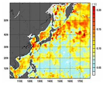
According to the investigation in April 2013, application of AMSR2 observation data made the difference in the analysis results from east of Hokkaido to the south Kamchatka on the Pacific Ocean (Figure 2.3.) With AMSR2 data, the quality of JMA's Sea Surface Temperature analysis is expected to improve, thus we started utilizing it in our system from May 27, 2013.