Acquisition of First Image from GLI Aboard Midori-II (ADEOS-II)
National Space Development Agency of Japan
The National Space Development Agency of Japan (NASDA) has acquired, as part of the initial function verification test, the first image from the Global Imager (GLI) aboard the Advanced Earth Observing Satellite-II, "Midori-II", which was launched on 14 December 2002.
The attached images show the feature over the Kyushu Island and the East China Sea taken at about 11:30 (Japan Standard Time) on 25 January 2003 (Fig.1), and the whirl of a low-pressure in the eastern offshore of the Hokkaido Island taken at about 9:45 (JST) on the same day, which were received by NASDA's Earth Observation Center (at Hatoyama-machi, Saitama Prefecture).
GLI is an optical sensor developed by NASDA, and has the world's top class performance to observe the reflected solar radiation from the Earth's surface with a 36- spectral channels ranging from ultraviolet to infrared. More specifically, GLI can make highly sophisticated observations at a global level over the distributions of sea surface temperature, snow, ice, clouds, aerosols, vegetation, ocean photo plankton, etc.
It is expected to contribute to understanding of long-term fluctuation mechanisms at a global level of the atmosphere, oceans, land and ice/snow areas by storing observing data from GLI.
- This information is also available in the following Internet address :
View of Kyushu Island, southern Japan, and the East China Sea as observed by the Global Imager (GLI) aboard Midori-II (ADEOS-II) at 11:30 (JST) on January 25, 2003.
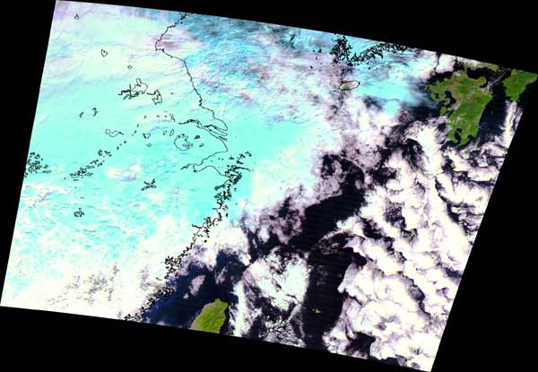
The color composite image was derived from the GLI spectral channels 28 (1640nm), 23 (825nm), and 22(660nm). The spatial ground resolution is 250m. Thick cloud systems stretching from the Asian continent to the East China Sea are visible in the image, with low altitude warm clouds appearing white and higher altitude ice clouds in blue. Kyushu Island and northern part of Taiwan can be identified at the chink of the clouds systems.
The GLI instrument has 36 spectral channels ranging from ultraviolet to infrared, designed for high accuracy observations of the atmosphere, ocean,land, and the cryospehre.
Global Imager (GLI) capturing a great winter cyclone, captured at 9:45 (JST) on January 25, 2003.
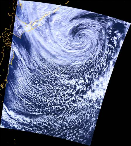
This color composite image was derived from the GLI spectral channels 13 (678nm), 8 (545nm), and 5 (460nm). It has a spatial resolution of 1 km. A great cloud system which has formed as a result of the cyclone at the eastern part of Hokkaido island can be identified in the image. The cyclone developed off the Pacific coast of Tohoku area between January 23 and 24, during which it brought severe weather conditions to eastern and northern part of Japan. The GLI instrument observes and measures the types and structures of clouds using a large number of spectral channels.
|
|