Acquisition of First Image from AMSR Aboard Midori-II (ADEOS-II)
National Space Development Agency of Japa
The National Space Development Agency of Japan (NASDA) has been currently conducting the initial function verification test for the Advanced Earth Observing Satellite-II, "Midori-II", which was launched on 14 December 2002.
As part of the test, NASDA's Earth Observation Center (at Hatoyama-machi, Hiki-gun, Saitama Prefecture) has acquired the image data from the Advanced Microwave Scanning Radiometer (AMSR) aboard "Midori-II".
The published data showing Japan and its vicinity were taken at the time of about 11:00 am and 8:30 pm on 18 January 2003 (Japan Standard Time). AMSR is able to detect clearly the movement of drifting ice even in the cloudy sky or at night, due to using the microwave for observation.
From now on, "Midori-II" will continue the initial function verification test and plan to acquire image data from other on-board sensors.
- This information is also available in the following Internet address :
Japanese Archipelago taken by AMSR
False Color-Composite Image
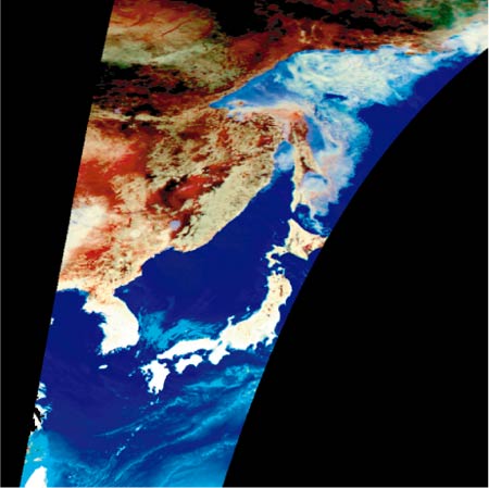
What is the Image
This is a false color-composite image sent by the Advanced Earth Microwave Scanning Radiometer (AMSR) on-board the Advanced Earth Observing Satellite-II, "Midori-II", both of which were developed by the National Space Development Agency of Japan (NASDA). Using 36.5 GHz horizontal polarization and 89.0 GHz vertical/horizontal polarizations, this was taken around 11:00am (Japan Time) on 18 January 2003.
The light blue color part in the ocean of the south part of Honshu indicates clouds including much moisture, and the light blue/white color part in the Sea of Okhotsk indicates drifting sea ice.
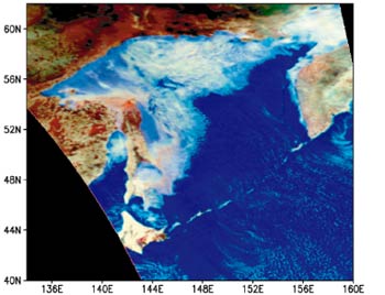
Distribution of Drifting Sea Ice over the Sea of Okhotsk
False Color-Composite Image
 |
 |
What is the Image
This image describes the drifting ice over the Sea of Okhotsk taken by the Advanced Earth Microwave Scanning Radiometer (AMSR) boarded on the Advanced Earth Observing Satellite-II, "Midori-II", both of which were developed by the National Space Development Agency of Japan (NASDA).
The figure on the left side is a false color-composite image obtained at night (around 20:30) on 18 January 2003, using 36.5 GHz horizontal polarization and 89.0 GHz vertical/horizontal polarizations. The light blue/white color part in the Sea of Okhotsk indicates drifting sea ice, and the light blue color part in the Pacific Ocean indicates clouds including much moisture.
Microwave observation has an advantage of detecting sea ice clearly regardless of day and night, and the presence of clouds.
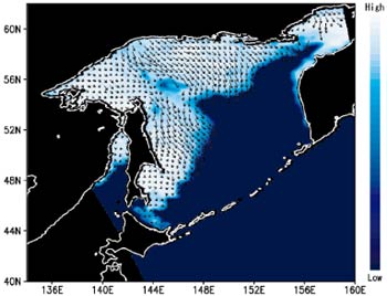
The figure on the right side shows the sea ice concentration obtained from the same data.
Dark blue color indicates the sea surface without ice and, whiter the color becomes, the more the sea covers with ice.
The arrows in the figure indicate the movement of sea ice based on the comparison of AMSR data obtained at about 11:00 am on the same day (10 hours before). It shows the movement of the sea ice from the northern part of the Sea of Okhotsk to the southern part, and at the same time, the approaching of the sea ice to the Shiretoko Peninsula.
This year, the sea ice has been coming southward earlier than usual, and the City of Abashiri observed it on 11 January 2003 for the first time of this winter.
|
|