Arctic Cryosphere Links Winter Climate to Summer Climate
-Understanding the Relationship between Winter Climate in the Arctic Region and Summer Climate in Japan-
Japan Marine Science and Technology Center
National Space Development Agency of Japan
A group of researcher from the Frontier Research System for Global Change (FRSGC: Joint project of the JAMSTEC and the NASDA)'s program for International Arctic Research Center (IARC) including Yoshihiro Tachibana, and Koji Yamazaki found a possibility to predict atmospheric circulation in summer from the relationship of pressure pattern between the North Atlantic region and the Arctic region in winter. So far, effects from the tropics such as El Nino on summer climate in Japan is well known, yet from this research, it was found that winter climate of the Arctic and high latitude regions is one of the most essential components to affect summer climate in Japan. Moreover, while researches to predict winter climate from summer climate have been known, in this research, it was proven that the climate of high latitudes in winter also affects the summer climate.
Figure 1
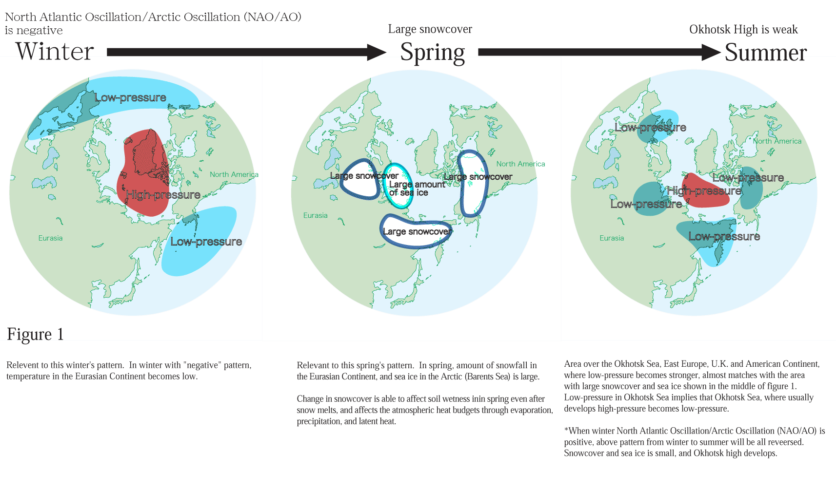
| Relevent to this winter's pattern. In winter with "negative" pattern, temperature in the Eurasian Continent becomes low. | Relevant to this spring's pattern. In spring, amount of snowfall in the Eurasian Continent, and sea ice in the Arctic (Barents Sea) is large. Change in snowcover is able to affect soil wetness inin spring even after snow melts, and affects the atmospheric heat budgets through evaporation, precipitation, and latent heat. |
Area over the Okhotsk Sea, East Europe, U.K. and American Continent, where low-pressure becomes stronger, almost matches with the area with large snowcover and sea ice shown in the middle of figure 1.Low-pressure in Okhotsk Sea implies that Okhotsk Sea, where usually develops high-pressure becomes low-pressure. *When winter North Atlantic Oscillation/Arctic Oscillation (NAO/AO) is positive, above pattern from winter to summer will be all reveersed.Snowcover and sea ice is small, and Okhotsk high develops. |
This research on the relationship between a pressure pattern of the North Atlantic and the Arctic region in winter, and atmospheric circulations in summer will be published in "Geophysical Research Letter" of American Geophysical Union in early August.
Background
A phenomenon, that Icelandic Low (note 1) and Azores High (note 2), both stay in the North Atlantic in winter, become stronger or weaker (seesaw phenomenon of the atmosphere), is called the North Atlantic Oscillation (NAO). From long ago, NAO is known as a phenomenon to dominate winter climate in Europe. Meanwhile, a seesaw phenomenon of the atmosphere between the Arctic region and mid latitude region is called the Arctic Oscillation (AO). When atmospheric pressure is low in the Arctic, it is called positive NAO/AO . When atmospheric pressure is high in the Arctic, it is called negative NAO/AO. So far, there was no research paper to discuss the summer atmospheric circulation in relation to winter NAO/AO. Meanwhile, Okhotsk high, which develops over Northern Japan in summer, is known as a high-pressure to bring anomalous cold summer or rice shortage, etc. in Japan. Okhotsk high is also considered to have a significant relationship with summer climate in Japan.
Results
By studying the annual atmospheric relationship between winter and summer, it was found that followed by a winter with a positive pattern of NAO/AO, in a summer, areas around 60 degree latitude of the northern hemisphere is covered by high-pressure, with Okhotsk high especially strong. A recent trend shows NAO/AO positive, with a possible relationship with global warming. Since Okhotshk high tends to develop when NAO/AO is positive, summer in Japan may not be necessarily hot due to the global warming. Contrary to this trend, NAO/AO was positive in this winter(reference 1), and thus Okhotsk high in this summer may not develop very strongly. Meanwhile, considering the fact that the atmosphere has only short memory, factors which have long memories such as continental scale snowfall, sea ice, and sea surface temperature, can be the climatic seasonal link between the Arctic regions in winter, and Japan in summer. In this winter, there have been large amount of snowfall and sea ice, as well as low sea surface temperature (Reference 2).
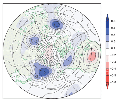 |
Correlation CoeficientIndex which shows the intensity relationship of the two amount. 1 means the two have very strong relationship, and 0 means no relationship.For example, Okhotsk Sea is about 0.6, which means winter atmospheric NAO/AO and summer Okhotsk high have quite a good relationship. |
Reference 1?Pattern of atmospheric flow in mid troposphere (around 5,000 meter high above the ground level) in early summer, when winter North Atlantic Oscillation/ Arctic Oscillation (NAO/AO) is negativeCorresponding to the area with large snowcover and sea ice, shown in reference 2, atmosphere over that area becomes low-pressure circulation. Low-pressure circulation over the Okhotsk Sea is especially large. Thus, Okhotsk high over the ground becomes weaker. Roughly speaking, high pressure stays in Arctic side, and low pressures stay around low latitute area (near the 60 degree north). |
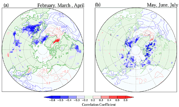
Reference 2 Distribution of spring snowcover and sea ice when winter North Atlantic Oscillation/Arctic Oscillation (NAO/AO) is negative
Reference2-a: Figure showing the amount of snowcover and sea ice, and change in sea surface temperature. Cold colors refer to more snowcover and sea ice as well as low sea surface temperature than usual years (meaning cold). There are a large snowcover in Europe, and sea ice in the Northern Europe.
Reference 2-b: Figure showing the "colder than usual year" from the snowcover, sea ice, and sea surface temperature in May, June, July. Amount of snowcover in East Siberia, north of Okhotsk Sea and American Continent is large, and there are large amount of sea ice in Northern Europe.
Contacts
- Frontier Research System for Global Change, Joint Promotion Office
Contact: Ms. Ota
Tel: +81 (0)45-778-5687 (direct) - NASDA, Public Relations Office
Tel: +81 (0)3-3438-6107, -6108, or -6109 - JAMSTEC, Public Relations Office, General Affairs Department
Tel: +81 (0)46-867-9066
Terms
Note 1 : Icelandic Low :
Semi-permanent low atmospheric pressure in the north of North Atlantic, which corresponds to Aleutian Low in the Pacific. Low-pressure formed in the North American continent and the Gulf of Mexico will move northeastwards over east coast of the North American continent, and develop, then end the final stage over the sea area around the Iceland Island.
Note 2 : Azores High :
A large high-pressure over the sea, which has a center in the south east of Azores in the east of North Atlantic. Airflow caused by temperature difference between the poles and the equator, will rise and flow towards the poles will accumulate over the subtropics. Part of it will decent and make a zonal high-pressure over the subtropical region. Azores high is part of this subtropical high pressure caused by this large-scale hemispherical flow. Azores high dominates throughout the year, and its center shifts a bit to the South in winter. Trade wind is part of this high-pressure, which flow northeastwards in the Southern half. These atmospheric pressure and wind systems expand widely to the Gulf of Mexico.
Relationship between Atmospheric Pressure of Arctic Region and Mid Latitude Area, and Summer in Japan.
| Pressure in the Arctic Region | Pressure in the Mid Latitude Region | NAO/A0 | Okhotsk High | Summer in Japan |
|---|---|---|---|---|
| Low | High | Positive | Strong | Cold |
| High | Low | Negative | Weak | Hot |
|
|