
Q. How did people in the affected areas respond to JAXA’s efforts?
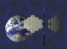
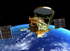
Wideband InterNetworking engineering test and Demonstration Satellite KIZUNA (WINDS)
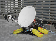
One-meter antenna for KIZUNA, set up at a local disaster-management office in an affected area
We received many compliments. However, at the same time, many local government officials said they wished they had known about JAXA’s capabilities earlier, so they could have asked for help immediately after the disaster. Prior to the earthquake, we had already conducted disaster drills using our satellites with some local governments. But we didn’t have such an agreement with Iwate Prefecture, and it was only through disaster-management staff from Niigata Prefecture – who were working with JAXA on a disaster drill at the time – that Iwate staff found out what we could offer. It was then that we fully realized the importance of PR to our disaster-management work.
Also, previously, antennas were set up mainly at prefectural and city government offices, but now there is a desire to install them in as many places as possible, such as evacuation centers. So we have received a request for easier setup of ground antennas, so that disaster-prevention workers can assemble them on their own. While the setup for ground antennas for KIKU No. 8 takes only two hours, a KIZUNA antenna takes much longer. In both cases, though, they are still experimental instruments, so they have to be assembled by specialists.
But if JAXA dispatches specialists to set up antennas in an affected area, we still need help from some prefectural government employees. Of course we try to trouble them as little as possible, but we have no choice but to ask them for certain things, such as finding and preparing locations for the antennas, and arranging permits for us to drive on the expressway to reach the affected areas. Maybe such things caused the bottlenecks. We contacted other local governments that were affected by the tsunami, but even though they understood the utility of having satellite links, our offer was sometimes turned down because they had other priorities and could not spare the staff to work with us.
Q. Will there eventually be enough antennas ready to go, so that communication links can be established by local workers themselves?
When a disaster occurs, it is important to set up the antennas as soon as possible, because satellite communications are a lifeline for people in disaster zones. KIZUNA and KIKU No. 8 are technology-demonstration satellites, but if in the future such satellites are made for practical use, I think the antenna setup will need to be simplified.
After the earthquake last year, we brought both antennas and power generators with us, because power was down in many places. Also, Japanese communications companies always have extra mobile antennas ready in every region for emergency use, and when a disaster occurs, they can quickly set up a temporary link. However, it still takes time to recover the Internet connection, so I think that there is a need for Internet satellites, which allow immediate communications as soon as a mobile ground station is set up.
Q. Since the earthquake, what have you learned about collaborating with local governments in a time of disaster?
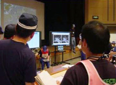
Local government disaster drill using satellite images
I realized the importance of making disaster-management agreements with local governments in advance. Then you can build rapport with their personnel by holding disaster drills. I discovered how important it was to have an environment where we know each other’s face. That makes it much easier to phone up and ask for help in an emergency.
With this in mind, we have been making agreements with as many local governments as possible since the earthquake. And we are integrating Earth observation satellites and communications satellites into prefectural disaster drills, so they can see how useful the satellites can be. If we can deepen our relationship with local governments this way, the next time a disaster occurs there will be a protocol for them to contact JAXA and use our services.
Q. What is the key issue for satellite applications in times of disaster?
It is whether we can provide data that is easy for anyone to use and understand. This has also been pointed out by local government staff. Only some of the data we had available was provided to them with explanations. In reality, though, it is impossible for us at JAXA to extract information about inundated and collapsed areas, for example, from the satellite data. This requires knowledge that only disaster-management specialists and local residents have.
So we are currently working on the establishment of local disaster preparedness centers for satellite data applications. If satellite images can be read by those who are familiar with local geography, and can then be distributed with explanations, it will help local government staff use the data more easily and effectively.
Q. Have satellites been used to predict disasters?
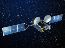
Global Change Observation Mission 1st – Water (GCOM-W1), also known as SHIZUKU
Meteorological satellites have long been used to predict typhoon paths. But scientists have also tried using different types of satellites to forecast other disasters. DAICHI has contributed to earthquake research by detecting the location of active faults. A demonstration test to determine the height of waves in the sea is in the planning stages, using Japan’s first quasi-zenith satellite, MICHIBIKI, which is currently in orbit. In addition, the Global Change Observation Mission 1st - Water (GCOM-W1), also known as SHIZUKU, is scheduled for launch in May of this year. It will measure precipitation, and is expected to help predict flooding.
However, in spite of such efforts, satellites are still in the early stages of contributing to disaster mitigation in Japan. In the meantime, JAXA is a collaborator in a project in Southeast Asia to use satellite and ground-based observations to predict floods and issue evacuation warnings.
Q. Is international collaboration in disaster management growing?
DAICHI, which completed its operations in May 2011, contributed to emergency disaster monitoring overseas in collaboration with the International Charter Space and Major Disasters, and with Sentinel Asia, of which JAXA is a member. Basically, DAICHI cooperated whenever there was an international request for emergency disaster monitoring. Meanwhile, when our earthquake happened last year, we received many images from foreign agencies and companies.
At that time, our observation capabilities were limited because DAICHI was Japan’s only Earth observation satellite equipped to respond to disasters. But we received about 5,000 satellite images from overseas, which allowed us to obtain data on areas DAICHI could not observe. So we were very thankful for the large amount of information provided from abroad.
Q. What is the potential for satellite applications in the future?
In my opinion, satellites will be used more and more, and will become an important part of our infrastructure. Right now, the satellites that are part of the infrastructure are mainly used in communications, broadcasting and weather observations, as well as the United States’ GPS network. In the near future, I think that Earth observation satellites, including Japan’s quasi-zenith satellite, will be added to the list. These satellites are expected to play an especially significant role in disaster management, and will also be able to contribute to the monitoring of the Earth’s environment and the ocean surface, as well in the field of agriculture.
In Fiscal Year 2013, Japan will launch the Advanced Land Observing Satellite-2 (ALOS-2), which has higher resolution than DAICHI. Also, we hope to consider enhanced versions of KIZUNA and KIKU No. 8. As for satellite communications, regular cell-phone towers should be upgraded, so they can be available in times of disaster. I think that in emergency situations it is ideal to be able to use familiar technology.
JAXA’s Satellite Applications and Promotion Center will continue to make efforts to improve the performance of satellites, to provide data promptly, and to promote cooperation within and beyond Japan.
Director, Satellite Applications and Promotion Center, JAXA
Mr. Gomi joined the National Space Development Agency of Japan (now JAXA) in 1982, and was involved in satellite design, operations, applications and tracking; planning for space activities; and international affairs. He has served as director of JAXA’s Satellite Applications and Promotion Center since 2009.
Tracking Earthquakes by Monitoring Crustal Deformation
Using Satellites to Study Volcanic Activity
Using Satellites to Help Local Communities
A New Satellite to Battle Large-Scale Natural Disasters