
In 1979, data reception from the U.S. Earth observation satellite Landsat 3 began at the Earth Observation Center (EOC). Image processing technology was also developed.
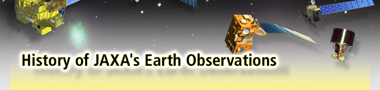
Launch Date: July 14, 1977
Launch Vehicle: Delta 2914 rocket (USA)
Operational Period: July 1977 to June 1989
Mission Objective: To obtain cloud imagery and meteorological observation data, including sea-level and cloud-top temperature. Starting with Himawari 6 (a.k.a. MTSAT-1R), launched in February 2005, operation of the Himawari series was handed over to the Japan Meteorological Agency, and its formal name was changed the Multi-functional Transport Satellite, to reflect its expanded mission.
Launch Data: August 13, 1986
Launch Vehicle: H-I rocket
Operational Period: Currently in operation (as of 2007)
Mission Objective: To map all of Japan, and determine the precise location of islands. To establish a new beginning for Japanese geodesy.
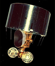
Experimental Geodetic Satellite Ajisai (EGS)
Launch Date: February 19, 1987
Launch Vehicle: N-II rocket
Operational Period: 1987 to November 29, 1995
Mission Objective: To observe ocean phenomena, and to establish basic technologies for Earth observation satellites. Its successor satellite, Momo-1b (MOS-1b) was launched in 1990, and conducted global observations, primarily of the oceans, until 1996.
Launch Data: February 11, 1992
Launch Vehicle: H-I rocket
Operational Period: 1992 to October 12, 1998
Mission Objective: Under the overall goal of surveying resources, to conduct a national land survey; to observe agriculture, forestry, fisheries, environmental preservation and disasters; and to conduct coastal surveillance. Also to develop active remote-sensing technology using the Synthetic Aperture Radar (SAR).
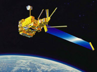
Launch Date: August 17, 1996
Launch Vehicle: H-II rocket
Operational Period: 1996 to June 30, 1997
Mission Objective: To observe global environmental changes such as global warming, ozone depletion, tropical rainforest phenomena, and extreme weather events. To distribute acquired observation data on the atmosphere, the oceans, and land, and to promote international cooperation. Also to develop technologies for next-generation satellites, including an Earth observation platform and inter-orbit communications for data relay.

Launch Date: November 28, 1997
Launch Vehicle: H-II rocket
Operational Period: Currently in operation (as of 2007)
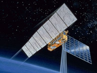
Mission Objective: To observe rainfall distributions in the tropics, which account for about two-thirds of global precipitation. To contribute not only to weather forecasting but also to understanding the mechanisms of global climate change, such as global warming and extreme weather. In this Japan-U.S. joint project, Japan is in charge of the launch vehicle and the development of the Precipitation Radar (PR); the United States (NASA) is in charge of the satellite body, the development of four observation instruments including the Lighting Imaging Sensor (LIS), and satellite operation.
Tropical Rainfall Measuring Mission "TRMM"
Launch Date: May 4, 2002
Launch Vehicle: Delta II rocket (USA)
Operational Period: Currently in operation (as of 2007)
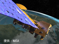
Mission Objective: To obtain observation data on the interaction between the Earth's atmosphere, the oceans and land, and on climate change. A joint project between the United States, Japan and Brazil. Japan is in charge of the development of a radio sensor for collecting data on the global water cycle. The sensor can observe land and ocean surface at night or in cloudy weather.
Earth Observation Satellite "Aqua"
Launch Date: December 14, 2002
Launch Vehicle: H-IIA rocket
Operational Period: 2002 to October 25, 2003
Mission Objective: To obtain data on global environmental changes such as global warming, ozone depletion, and extreme weather events. The technologies for observing the oceans and the atmosphere are upgraded from Midori (ADEOS). The observation data is to be used for international climate-change research, and is also aimed at practical use in meteorology and fishery.
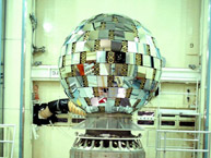
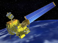
Launch Date: January 24, 2006
Launch Vehicle: H-IIA rocket
Operational Period: Currently in operation (as of 2007)
Mission Objective: To contribute to mapping, disaster monitoring, regional observation and resource surveys, and to develop new Earth observation technologies. Also, to use the satellite for practical applications, such as data distribution and emergency observations during natural disasters. The land observation technology is upgraded from Midori (ADEOS).
Advanced Land Observing Satellite Daichi (ALOS)
Hideshi Kozawa Satoru Nishikawa Tatsuya Yamashiro / Munehiro Nagumo Orbita Roswintiarti History of JAXA's Earth Observations