EarthCARE (Earth Clouds, Aerosols, and Radiation Explorer) is a joint Japanese-European mission to observe clouds and aerosols above the Earth in three dimensions. Aerosols are suspensions of small particles of debris in the atmosphere, and work as cloud condensation nuclei: they activate water condensation to become cloud particles, which then form clouds.
EarthCARE is designed to map vertical profiles of clouds through three-dimensional observation, and to measure the water volume contained in clouds, cloud particle size, and the ascent and descent of clouds. Its launch by ESA, the European Space Agency, is scheduled for 2013.
EarthCARE is designed to map vertical profiles of clouds through three-dimensional observation, and to measure the water volume contained in clouds, cloud particle size, and the ascent and descent of clouds. Its launch by ESA, the European Space Agency, is scheduled for 2013.
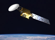
EarthCARE - Earth Clouds, Aerosols and Radiation Explorer (courtesy: ESA)
Clouds have a great impact on temperatures on Earth.
- Wind chill temperature varies with the cloudiness of the sky.
- Clouds absorb heat released from the land surface and oceans, which raises global temperatures.
- At the same time, clouds have a cooling effect by blocking radiant sunlight.
The magnitude of these heating and cooling effects depends on cloud thickness, the number of cloud layers, altitude, water volume, and cloud particle size. For example, clouds at a higher altitude have a greater heating effect, and clouds at a lower altitude have a greater cooling effect.
Aerosols, some of which humans put into the atmosphere as pollutants, have characteristics of reflecting and absorbing sunlight, so their presence also greatly affects cloud properties. For instance, the abundance of aerosols has an impact on the brightness and lifespan of clouds.
However, these phenomena have not yet been explained scientifically because advanced surveying of clouds and aerosols over the entire globe has barely begun. It has been impossible to carry out thorough observations from the ground because of the sheer scale of clouds---they can be hundreds of kilometers wide. With the EarthCARE satellite, we will finally be able to observe and learn about the influence of clouds and aerosols on global warming, and how it relates to the global climate.
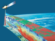
EarthCARE studying three-dimensional profiles of clouds (courtesy: ESA)
EarthCARE's main scientific instruments are the Cloud Profiling Radar (CPR) and the Atmospheric Backscatter Lidar (ATLID). Europe is responsible for the backscatter lidar; JAXA is developing the CPR with the National Institute of Information and Communications Technology (NICT). CPR measures cloud particle size, water volume, and vertical profiles of clouds, using high-frequency (94GHz) radio waves. Furthermore, CPR will be the world's first onboard radar to measure the ascending and descending velocity of cloud particles and reveal convection currents in clouds.
Cloud particles are so small that high-frequency radio waves are needed for observation. The observation requires a powerful radio wave transmitter and a large-scale antenna with an advanced reflector. Technically the development is very difficult, especially considering that the radio waves must be transmitted continuously throughout the three-year mission. However, thanks to NICT's longterm research, we have the background to develop the largest ever onboard 94 GHz antenna (with a diameter of 2.5 meters). This antenna will enable observation with ten times more sensitivity than any existing satellite radars.
The backscatter lidar can monitor finer aerosols and very thin clouds that are unobservable by CPR. Such a combination of lidar and radar will allow the simultaneous measurement of the distribution of different sizes of cloud particles and aerosols, revealing the three-dimensional structure of clouds. Beyond the vertical profiles of clouds, we also anticipate new scientific discoveries about the processes of cloud formation and dispersion, and about the correlation between clouds and aerosols. For these to happen, I would like to dramatically increase the accuracy of the numerical model.
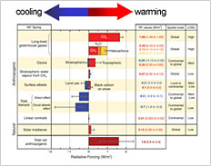
(Figure 2) Main error factor in human-activity-related climate change prediction (Reference: IPCC-AR4/WG1, fig. SPM-2)
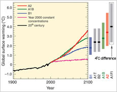
(Figure 1) Multi-model global averages of surface warming (Reference: IPCC-AR4/WG1, fig. SPM-5)
The latest report of the Intergovernmental Panel on Climate Change (IPCC), published in 2007, predicts that Earth's average temperature will increase over the next hundred years. This prediction was made based on a supercomputer simulation using numerical climate models that were developed based on previous observations. However, questions still remain about the accuracy of such predictions. Many nations, including Japan, the U.S., and some European countries, make their own predictions, but while one nation predicts the increase will be 2°C, another says it will be 6°C. That is, there is a 4°C difference in the predictions (Figure 1). Considering that the increase of global temperature in the last 100 years was about 0.7°C, a 4º difference is too significant to ignore. What are the reasons for the discrepancies? Whose method is more accurate? These questions are important to answer before we can move forward.
There is a chart that summarizes the influence of climate elements related to human activities on global warming and cooling effects (Figure 2). This tells us that carbon dioxide and ozone contribute to global warming, and aerosols contribute to global cooling. The horizontal lines on the graph indicate the margin of error. For example, it is clear that aerosols and clouds have a cooling effect, but it is not clear whether the impact is 2 watts or 0.5 watts. This uncertainty is thought to be the major cause of the 4°C difference mentioned above. Fortunately, this problem will soon be resolved as we learn more about clouds and aerosols through the EarthCARE mission. When climate change prediction is improved, I believe that it will help countries around the world take appropriate action on environmental issues.
Under JAXA's policy to develop multiple satellites for comprehensive Earth observation, EarthCARE will work in collaboration with JAXA's Global Change Observation Mission - Water (GCOM-W, scheduled for launch in 2011, around the same time as EarthCARE), and Global Precipitation Mission (GPM, scheduled for launch in 2013).
Clouds are formed when air-borne dust mixes with water vapor. Clouds disperse through rain or evaporation. Without understanding such processes, it is impossible to understand cloud behavior in depth. A single satellite may not be adequate for this kind of observation, but by using multiple satellites, comprehensive observation becomes possible. For us to implement such observation, GCOM-W is designed to measure the volume of water vapor in the atmosphere; EarthCARE aims to study the process of cloud formation from aerosols; and GPM will observe the process of clouds turning into precipitation.
Beyond these missions, JAXA is currently considering a project called the Global Change Observation Mission - Climate (GCOM-C). It will not investigate clouds vertically but will cover a much wider horizontal range (about 1450 km) than EarthCARE, which surveys 150 km at a time. If it becomes possible to combine the results of these two satellites, we will be able to assess three-dimensional distributions in very wide areas.
Although EarthCARE is a joint Japanese-European mission, we are also working closely with NASA, which launched CloudSAT in 2006 to carry out the world's first three-dimensional observation of clouds. We have a very good relationship with them, exchanging researchers and sharing data. EarthCARE's specifications, for example, are based on what NASA learned with its previous mission. I am hoping that our collaboration with the U.S. and Europe will continue, especially in the areas of application and assessment of observation data.
As well as data collected by its other liaison satellites, EarthCARE's data will be processed at, and published by, the JAXA Earth Observation Research Centre. However, satellite data is not meaningful to laypeople, and the main users will probably be organizations such as the Japan Agency for Marine-Earth Science and Technology, which runs the Earth Simulator Center, and institutions that research numerical climate models, such as the Japan Meteorological Agency, the National Institute for Environmental Studies, and the Center for Climate System Research at the University of Tokyo.
To make the data easier for the general population to understand, we plan to publish it in graphic form on the Internet. We collaborate with research institutions on data applications, such as developing algorithms for data analysis.
The primary objective of the EarthCARE mission is to improve the accuracy of climate change prediction. By precisely monitoring how climate alters in response to changes in our society, the project promises to help Japan and other countries with global warming and climate change issues. Meteorologists and related organizations are also awaiting EarthCARE data to increase the accuracy of weather forecasting.
I am looking forward to the day when our project can start providing useful information that will improve lives on Earth.
Dr. Toshiyoshi Kimura
Project Manager of the Earth Clouds, Aerosols and Radiation Explorer/Cloud Profiling Radar (EarthCARE/CPR), Space Applications Mission Directorate, JAXA
Dr. Kimura graduated from the Faculty of Science at Kyoto University in 1987, and joined an aerospace manufacturer, where he developed the Global Imager for the Advanced Earth Observation Satellite-II, Midori-II. In 2001, he joined the National Space Development Agency of Japan (now part of JAXA), and was involved in the initial study for the GOSAT, GCOM, and EarthCARE missions. He received his Ph.D. in atmospheric physics from the University of Tokyo in 2002, and was appointed to his current position in 2008.
To Protect the Environment for a Peaceful Life
Measuring Greenhouse Gases from Space
Understanding the Global Water Cycle
Long-term Environmental Change: Observations of Earth
Three-Dimensional Observation of Clouds and Aerosols
Water, Air, and Waste Recycling
Measuring Greenhouse Gases from Space
Understanding the Global Water Cycle
Long-term Environmental Change: Observations of Earth
Three-Dimensional Observation of Clouds and Aerosols
Water, Air, and Waste Recycling