The Global Change Observation Mission (GCOM) aims to observe environmental changes on Earth continuously for at least ten years. We will launch several GCOM-W (Water) and GCOM-C (Climate) satellites, which will allow us to:
- improve the accuracy of our climate change predictions,
- improve people's daily lives, for example, to improve weather forecasts, and to assist the fishing industry.
The prototype of the first GCOM-W satellite has been developed, and we are working towards a launch via a H-IIA launch vehicle in 2011. A GCOM-C satellite is also scheduled for launch around 2013.
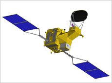
The water circulation change observation satellite GCOM-W.
By receiving microwaves from the Earth, the GCOM-W will make observations of water, including:
- seawater temperatures,
- precipitation levels,
- the amount of vapor in the atmosphere,
- groundwater levels, and
- snow depths.
The antenna on the Advanced Microwave Scanning Radiometer 2 (AMSR2) aboard the GCOM-W, with a diameter of about two meters, is the world's largest antenna for an observation sensor aboard a satellite. It will spin around once every 1.5 seconds to scan 1,450-km arcs of the Earth's surface. This means it will observe the entire globe every two days. The AMSR2 requires very complex technology for continuous observations over the scheduled mission period of five years.
NASA's Earth observation satellite Aqua, launched in 2002, carries JAXA's microwave radiometer AMSR-E, which is performing observations right now. Although more than six years have passed since the launch, the AMSR-E still provides stable data from its orbit and has gained respect around the world for its achievements and high reliability. The AMSR2, which is under development for the GCOM-W, is an upgrade from the AMSR-E and is expected to be able to acquire more accurate data.
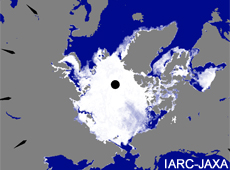
Ice in the Arctic Ocean captured by the Aqua/AMSR-E.
Climate change predictions using computers have previously been made in the following manner:
1. By dividing the atmosphere and surface of the Earth into several hundred million lattice points.
2. By inputting known observation data for each point.
3. By performing numerical simulations to predict future climate changes.
These predictions require highly accurate data about the Earth's land, oceans, and atmosphere. It is impossible to obtain all this data through observations on the ground. Instead, Earth observation satellites are used to observe the entire globe from space.
The climate observation satellite GCOM-C will observe clouds, aerosols (small particles of dust in the atmosphere), sea color, vegetation, snow, and ice, in wavelength ranges from visible rays to infrared rays. The Second Generation Global Imager installed on the GCOM-C is able to observe the climate system of the entire Earth (atmosphere, oceans, and land) with a 250-meter resolution.
Since clouds and aerosols reflect sunlight (and reduce the amount of light that reaches the ground) it is believed that they have a cooling effect on the Earth's temperature. However, observing aerosols over land areas is technically very difficult due to the reflection of light from the ground, so only limited observations have been performed up to now. This means that current climate-change predictions are somewhat uncertain. The optical sensor of the GCOM-C has a polarizing function to eliminate the reflection problem when measuring aerosols, and can observe the whole area of the land and ocean. Thus, we can understand, on a global scale, the influence clouds and aerosols have on global warming.
Information about vegetation and sea colors helps identify carbon circulation patterns around the Earth. Carbon dioxide is the main cause of global warming, and plants counteract this effect by absorbing it. In order to predict climate change, it is important to know where, and how much, carbon dioxide is absorbed.
The term "red tide" describes the change in sea color when marine organisms increase in number. The GCOM-C will observe the color of the world's oceans and measure the amount of phytoplankton.
To study how much forests are growing, the GCOM-C will look at them from a diagonal view, in order to count and compare the numbers of tall and short trees. From this, we can correlate the biomass of forests and the amount of carbon absorption. Currently, unknown man-made emissions of carbon dioxide and their unknown degree of absorption present a problem for predicting climate change, although simulations on how nature absorbs carbon dioxide are now gradually improving.
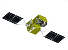
The climate change observation satellite GCOM-C.
The Intergovernmental Panel on Climate Change (IPCC) has made predictions for climate change on Earth over the next 100 years. However, the accuracy of these predictions is limited, because there is not enough quality long-term data.
Thus, we are promoting the development of the GCOM-W for water circulation observations and the GCOM-C for climate change observations. Our goal is to launch three of each of these, in successive pairs, to function over a total period of 13 years. The lifespan of each satellite is expected to be five years, but to calibrate the sensors of each satellite and its successor, their operations in orbit will overlap for about a year. In total, the three generations of GCOM satellites will function for about 13 years. This will be JAXA's first attempt at such long-term observations.
Earth observation satellites can monitor radio waves emitted from the surface of the planet. You can identify the material on the ground or its nature by the wavelength reflected or emitted, or by a combination of several wavelengths. If you use a range of wavelengths for observations, you can monitor a greater variety of materials. The GCOM will observe the entire Earth using two kinds of satellites, which cover a very wide range of frequencies, from optical rays to microwaves.
In 2002, we launched the Advanced Earth Observing Satellite-II (Midori-II), which had similar types of functions to the GCOM, but unfortunately the satellite experienced trouble and we had to give up on the observations. The Midori-II became very large, because we installed several types of sensors on it. Utilizing these lessons learned, the GCOM is working on two types of satellites. They carry different kinds of sensors, but to reduce costs, the basic satellite-bus design is the same.
The GCOM will observe Earth in cooperation with other satellites, both JAXA's and those of other countries. First, there is a long-term Earth observation project, the National Polar-Orbiting Operational Environmental Satellite System (NPOESS), led by the National Oceanic and Atmospheric Administration (NOAA) of the United States. JAXA and NOAA are talking about utilizing international cooperation for mutual data exchange. Second, we would like to cooperate with the European Space Agency and the National Aeronautics and Space Administration.
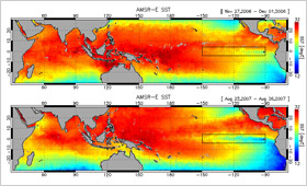
El Niño (top) and La Niña (bottom) captured by the Aqua/AMSR-E. The red parts show higher sea temperatures and the blue parts show lower sea temperatures.
The sea surface temperature data observed by the GCOM will be provided to Fishery Information Service Centers for use in researching fishing areas. The habitat of fish changes depending on the sea temperature, so sea temperature data is very important to the fishing industry.
We can observe sea surface temperature increases, known as El Niño, and the opposite phenomenon, known as La Niña. As these phenomena are known causes of abnormal weather (such as floods and droughts) all over the world, we believe the GCOM will contribute to preparations and countermeasures for natural disasters.
The GCOM's observations will contribute to improved accuracy of weather forecasts, monitor natural disasters such as heavy rainfalls or typhoons, and monitor small particulates that cause air pollution. We will also provide marine vessels with safety information about floating ice around the Sea of Okhotsk.
The observation data from the GCOM will be verified for its quality and accuracy, and is then scheduled for release to general researchers. We hope the data from GCOM will be indispensable and beneficial to human society world-wide.
Keizo Nakagawa
Project Manager of the Global Change Observation Mission (GCOM) Project Team, JAXA Space Applications Mission Directorate
Mr. Nakagawa graduated from the Department of Aeronautical Engineering at the Graduate School of Engineering, Kyoto University, in 1982. In the same year, he joined the former National Space Development Agency (currently part of JAXA). Prior to working on the GCOM project, Mr. Nakagawa worked on the development of the Broadcasting Satellite-3 (BS-3) “Yuri” and the Optical Inter-orbit Communications Engineering Satellite (OICETS) "Kirari". He was posted to his current position in 2007.
To Protect the Environment for a Peaceful Life
Measuring Greenhouse Gases from Space
Understanding the Global Water Cycle
Long-term Environmental Change: Observations of Earth
Three-Dimensional Observation of Clouds and Aerosols
Water, Air, and Waste Recycling
Measuring Greenhouse Gases from Space
Understanding the Global Water Cycle
Long-term Environmental Change: Observations of Earth
Three-Dimensional Observation of Clouds and Aerosols
Water, Air, and Waste Recycling