Q. What kind of discussions were held, and what kind of future direction was decided at the GEO ministerial meeting in Beijing in November 2010?

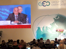
GEO ministerial summit, Beijing, November 2010 (courtesy:GEO)
At the GEO ministerial meeting in Beijing, importance was placed on continuing to provide access to observation data. Organizations working in environmental management, as well as in science, recognized again the need for the Global Earth Observation System of Systems (GEOSS). Governments require observation data on all issues, and they have expressed a high regard for the usability of GEOSS.
To achieve free access to data, we received support from members to set up a utilization system, in order to distribute the vast amounts of observation data provided to GEO. To be more specific, we are going to use the DataCore approach and provide free access to GEO’s observation data to everyone.
They also agreed to maintain GEO and its activities over a much longer period. One of the things we have decided for the future is to look into a legal framework that would allow GEO to continue its work after 2015. GEO has been established based on the 10-year Implementation Plan beginning in 2005.
In addition, we received support from ministers on Carbon Project, Forest Carbon Tracking, and the Group on Earth Observation Biodiversity Observation Network (GEO-BON). GEO-BON is organized under GEOSS, and its goal is to make global observations on biodiversity, which previously were performed only in selected areas.
Q. How do you evaluate cooperation from JAXA on GEO’s Carbon Project?

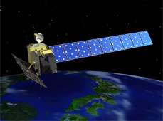
Advanced Land Observing Satellite DAICHI
JAXA carries out impressive Earth observations satellite programmes. As a result, JAXA is currently leading the world by performing forest observations with the Phased Array type L-band Synthetic Aperture Radar (PALSAR) aboard the Advanced Land Observing Satellite DAICHI. This is a very critical instrument for measuring forest area and estimating amounts of carbon stored in these forest.
The Greenhouse Gases Observing Satellite IBUKI is the only satellite in the world that specializes in measuring the amount of carbon in the atmosphere. In addition to the observation data from IBUKI, which is very important, data from the Earth observation satellites of the European Space Agency and NASA will also be used. Originally, data from NASA’s Orbiting Carbon Observatory (OCO) was supposed to be used as well, but unfortunately its launch ended in failure in 2009. Thus, until OCO-2 is launched, the current observation data from IBUKI constitutes the most valuable carbon observation statistics in the world. Q. What are your expectations for JAXA in the future?I would like to further promote the greenhouse gas monitoring project that JAXA has been putting a lot of effort into. I hope they will make progress in the analysis of observation data from IBUKI and make it available to the Carbon Project.
José Achache
Director of the Secretariat, Group on Earth Observations (GEO)
Prof. Achache obtained a Ph.D. in Geophysics from the Pierre et Marie Curie University in Paris, and a Ph.D. in Physical Sciences from the René Descartes University in Paris. In 1989, he was appointed professor at the Institut de Physique du Globe de Paris (IPGP). After serving as principal of the Graduate School of Earth Sciences at IPGP, he became Vice-President for Research and Development at the Bureau de Recherches Géologiques et Miniéres, the French Geological Survey. In 1999, Prof. Achache became an advisor to the President of the Centre National d’Etudes Spatiales (CNES), the French Space Agency, then Deputy Director General of CNES in 2000. He was subsequently appointed Director of Earth Observation Programs at the European Space Agency. In 2004, Prof. Achache became Director of ESRIN, the ESA Center in Italy. He was posted to his current position as Director of the Secretariat of GEO in 2005.
Researching the Carbon Dioxide Cycle
World’s First High-Resolution Global Forest/Non-Forest Map
Japan Contributes to Efforts to Solve Environmental Problems
Policymakers Worldwide Need Unified Carbon Cycle Data
Reliable Data Essential for Greenhouse Gas Reduction


