Q. What is JAXA’s role in standardizing data for the GEO carbon project? And what is your responsibility in this regard?
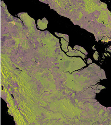
Eastern Sumatra in Indonesia. Green indicates forested area and purple indicates deforested or non-forested area. ©JAXA,METI analyzed by JAXA
The first meeting to discuss standardization, including what kind of data to provide and how to present it for ease of understanding, was held in Canberra, Australia, in April 2009. It is important to provide accurate, easy-to-use data to researchers around the world, but the reality is that data contains no small measure of errors. So part of our effort toward standardization is to decide on a processing variable, so that the data can be calibrated to minimize the errors. In that sense, I think the validation process - which uses data collected by satellites from different countries observing the same locations at the same time - contributes to standardization.
I am involved in standardization of SAR data, and I am studying how to calculate the changes in forest area and in the amount of biomass from the density contrast image of the forest/non-forest map. Biomass is biological material derived from living, or recently living, organisms. Woody biomass is what is left after moisture has substantially evaporated from wood, with carbon comprising up to half of the total remaining mass. As the initial source of this carbon is carbon dioxide absorbed from the atmosphere, it is possible to accurately determine the amount of carbon absorbed by the forest. Q. What is the current status of and the future plan for the standardization of carbon data? Our ultimate goal is to accurately calculate the amount of biomass, and today we are almost halfway there. The data analysis is becoming more and more sophisticated. Rather than simply making a broad distinction between forest and non-forest, and thus measuring only changes in the overall volume of forests, it is increasingly possible to distinguish between types of forest - for example natural forests, mountain forests, or palm-oil plantations.
Also, we are finding that the brightness of SAR images corresponds to the amount of biomass only up to a certain point - up to 100 to 150 tons per hectare. In denser forests that’s no longer the case. To solve this problem, we need to know the density of the forest and the height of the trees, but current data is not accurate enough. So improving the quality of biomass data is a major priority for the future.
In the meantime, the accuracy of the information collected by satellites needs to be verified. To do so, it is important to examine the locations in person or obtain forest information from local authorities. So I think it is essential to build a cooperative structure where we provide satellite data, and acquire ground observation data from local institutions in return.
Accurate measurement of biomass is a significant challenge for researchers around the world, not just in Japan. JAXA aims to achieve this ultimate goal in the next three years, and to do this it is essential to collaborate with other organizations. At present, we are working in cooperation with the Japan International Cooperation Agency and Japan’s Forestry and Forest Products Research Institute. Also, to develop new forest-monitoring applications for data from DAICHI, we have invited international organizations, such as NASA’s Jet Propulsion Laboratory, to exchange opinions.
Q. How would you like to see carbon data collection evolve in the future?
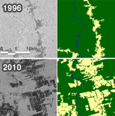
Comparison of Pará state in the Amazon region of Brazil in 1996 and 2010. On the left are satellite images, and on the right are images distinguishing forested and non-forested areas, with forested areas indicated in green. ©JAXA,METI analyzed by JAXA
![]()
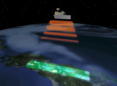
The volume of trees does not increase or decrease suddenly, so you can follow changes in forest area and amount of biomass by comparing data by decade. Also, to improve accuracy, it is important to obtain data over the long term. DAICHI is not the first satellite to perform forest monitoring. The Japanese Earth Resources Satellite-1 (JERS-1) used SAR to map rainforests and boreal forests from 1995 to 2003. This led to the development of a forest-monitoring project using the PALSAR instrument on DAICHI, called the DAICHI Kyoto & Carbon Initiative.
JAXA is now planning to launch the successor to DAICHI in 2013,which will perform even higher-resolution measurements and thus deliver higher accuracy. Despite the fact that it has been almost five years since DAICHI was launched, there is no sign of degradation in its sensor’s performance. Given the amount of fuel left, it will probably be able to continue observations for another seven years, which means that, once the new satellite is launched in 2013, we will have two satellites doing forest monitoring. I think continuous observation will improve the reliability of carbon data. Q. Finally, could you tell us about your vision for the future? I think it was in 1992 that I saw a SAR forest-monitoring image for the first time. It was data taken from the sky above the Amazon. I could easily tell that deforestation was happening, because a part of the forest was dark. I was amazed that satellite observation could reveal deforestation. When DAICHI imaged the same spot in 2006, the dark area was much bigger, so it was clear that deforestation had increased. Forest monitoring is important in fighting global warming, which we are facing now, as well as in forest conservation, so I think that it provides a very significant benefit to society. I would like to continue to contribute to society as much as possible.
I also would like to work with institutions in countries that have large forests to build a forest monitoring system that integrates satellite and ground observation. And I hope that the data will always be published for people around the world to use for free, to help prevent global warming.
Masanobu Shimada, Dr.Eng.
DAICHI Research and Application Project
Associate Principal Researcher, Earth Observation Research Center (EORC), Space Applications Mission Directorate, JAXA Dr. Shimada received an M.Eng. degree from Kyoto University in 1979, and joined the National Space Development Agency of Japan (now part of JAXA). Since then he has worked on the development of microwave scatterometers at the Tsukuba Space Center, on ground-facility development for the JERS-1 satellite, and on SAR applications research at EORC. He conducted research on accurate measurement of backscattering coefficient, and received a doctorate from the University of Tokyo in 1999. He specializes in microwave remote sensing, SAR processing, interferometric SAR, and analysis of alternating polarization SAR. He became an IEEE fellow on Jan. 1, 2011.
Researching the Carbon Dioxide Cycle
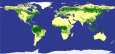
World’s First High-Resolution Global Forest/Non-Forest Map
Japan Contributes to Efforts to Solve Environmental Problems
Policymakers Worldwide Need Unified Carbon Cycle Data
Reliable Data Essential for Greenhouse Gas Reduction