The Earth is changing constantly, every day, due to natural disasters such as earthquakes, floods, volcanic eruptions and landslides, and damage inflicted by humans, such as illegal logging. The Advanced Land Observing Satellite-2 (ALOS-2), also known as DAICHI-2, will closely observe these phenomena. Following in the footsteps of ALOS, this new satellite will have a wide range of uses, such as studying the nature of disasters and solving environmental problems. In Japan and around the world there are high hopes for the satellite, which will soon be launched on an H-IIA Launch Vehicle.
The Earth needs a health check.
— What kind of satellite is ALOS-2?
The Advanced Land Observing Satellite-2 (ALOS-2), also known as DAICHI-2, is the successor to ALOS, which operated from 2006 to 2011. It’s equipped with PALSAR-2, a more advanced L-band Synthetic Aperture Radar than PALSAR. ALOS-2 will closely observe activity on land, following a polar orbit, flying over Japan twice a day, at around noon and midnight.
— How will this satellite contribute to our wellbeing?
ALOS-2’s roles can be divided into three categories:
- 1. It will protect our wellbeing and contribute to fighting disasters. ALOS-2 will determine the nature and extent of damage when disasters occur: the deformation of the Earth’s crust, known as diastrophism, which accompanies earthquakes; flooding due to typhoons and tsunami; and lava flow during volcanic eruptions. It will also measure changes in terrain caused by landslides and subsidence, thus helping prevent disasters.
- 2. It will contribute to solving environmental problems such as global warming. Its first task in this respect is to create a comprehensive map of the Earth’s forests. Forests absorb greenhouse gases, which cause global warming. If we can accurately measure the actual area covered by the Earth’s forests, then we can estimate the amount of carbon they absorb. Illegal logging has been a frequent occurrence in recent years in countries such as Brazil, but if we can detect it, then that can help stop it and conserve the environment. In addition, the effects of climate change are most apparent in the polar regions. By observing the polar regions’ glaciers over the long term, the satellite will contribute to easing environmental problems. Also, for example, information on ice floes in the Sea of Okhotsk will be provided to the Japan Coast Guard, and used to ensure the safety of ships.
- 3. The third role is to contribute to society at large, and to the economy. For example, by measuring how much land is used for wet-field rice cultivation, the satellite will help solve food-related problems. Due to population growth in Asian countries, these problems are severe. To tackle food shortages, it is important to monitor the state of agriculture in Japan and elsewhere in Southeast Asia. In addition, the satellite will probe underground resources. For example, off-shore oil reserves can sometimes be detected by spotting oil leaks on the ocean’s surface. Detecting such leaks will help find new resources.
— So ALOS-2 will even investigate forests and wet-rice cultivation. Please tell us about the features of PALSAR-2.
L-band Synthetic Aperture Radar (PALSAR-2)
PALSAR-2 can function both day and night and penetrate rain and clouds, so it won’t be hampered by weather. In particular, the L-band Synthetic Aperture Radar (SAR), which uses long wavelengths, can see the ground through leaves and branches, so it can closely observe activity on land. Using SAR to scan the Earth’s surface through clouds and vegetation is similar to using X-rays or a CT scan to examine our bodies. Also, the annual contraction of forests and polar glaciers has unknown effects on climate change – this is like the lifestyle-related diseases that affect us humans as we live longer. For humans, getting regular check-ups can help prevent disease. This project is based on the idea that in this sense, the Earth too needs a health check. [DAICHI means land in Japanese.]
— Is the L-band Synthetic Aperture Radar a technology developed in Japan?
Yes, it is. The L-band Synthetic Aperture Radar was first installed on JERS-1, the Japan Earth Resources Satellite-1, which was launched in 1992, and then on ALOS, which was launched in 2006. So ALOS-2 will be the third satellite to carry it. Japan has been continuously working on improving the technology, and today its observation capabilities lead the world.
More detailed and faster!
— ALOS-2 is the successor to ALOS. How is it different?
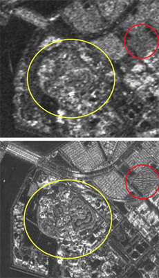
Comparison of SAR resolution. The shapes of condominiums (marked with a red circle) and the main structural object (marked with yellow circle), which are not identifiable in the image taken by ALOS/PALSAR, are identifiable in the simulation image of ALOS-2/PALSAR-2 (lower image).
It has improved spatial resolution, it can make more frequent observations and it is faster. In contrast to ALOS/PALSAR, which could spot objects as small as 10 square meters, ALOS-2/PALSAR-2 will be able to see objects as small as 3 square meters. On top of that, when we use its new spotlight mode, we will be able to observe objects as small as 1 square meter along the satellite’s flight path.
Additionally, we’ve customized the SAR to allow us to observe in both daytime and nighttime. Since the satellite’s predecessor was fitted with both optical sensors and SAR, it used the former during the day and the latter primarily at night. Also, the PALSAR on ALOS could only “see” on its right side due to the location of its optical sensors. ALOS-2 will be able to make observations on both sides, so the observable range will expand from 870 km to 2,320 km.
The new satellite’s response time is also faster. We achieved this in part by lowering the satellite’s altitude. Its predecessor orbited 691 km above the ground; ALOS-2 will be at 628 km. By selecting a good altitude and orbital inclination, we were able to reduce the number of days it takes to observe the entire Earth and return to its starting position (known as revisit time) from 46 to 14 days. In short, we will be able to image an area in need of observation much more quickly than before. In most cases, the satellite will be able to observe an area in Japan’s vicinity within 12 hours of a request (except for the nadir area, which can’t be observed by SAR), and an area elsewhere in Asia within 24 hours. We plan to provide the standard products about an hour after the downlink.
In addition, we needed to make the satellite lighter in order to reduce both cost and technical risk. That’s one of the reasons why it carries only SAR. ALOS-2’s mass is just 2 tonnes, or about half that of its predecessor. Other upgrades include more precise orbital controls for the satellite, and improved observational accuracy for the SAR. Compared to its predecessor, ALOS-2 is far more advanced.
— Will the customized SAR lead to more robust disaster response?
Yes. The main purpose of ALOS-2 is rapid disaster response. When a disaster occurs, the most important thing is to observe the site as soon as possible and quickly make the information available. Since the SAR can observe day or night in all weather conditions, it will be able to provide very prompt disaster information. Its greater observable range is also a big help.
High hopes for ALOS-2 from the rest of the world
— ALOS-2 is scheduled for launch on an H-IIA Launch Vehicle from the Tanegashima Space Center on May 24, 2014. Tell us about the post-launch operations schedule.
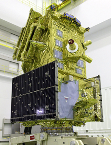
ALOS-2 ready to launch
After the satellite enters orbit, we will run checks for 80 days or so, to make sure all equipment is functioning properly in space. When the satellite is stable and ready to operate, we will begin routine observations. I would like to release the first observation images four weeks or so after launch, but data won’t be distributed outside JAXA until it’s been calibrated, about six months after launch. However, if a major disaster occurs before then and an emergency response is needed, I would like to provide even uncalibrated data.
— How long will the satellite be in use?
It is designed to have a life of five years, and our target is seven years. We have ensured that it has enough fuel and performance capability to operate for seven years. We hope it will be up there for a long, successful run.
— Will all the data from ALOS-2 be analyzed at JAXA’s Earth Observation Research Center (EORC)?
No. Based on our experience with ALOS, we will be sharing the data with government agencies. For example, data on crust deformation is useful to the Geospatial Information Authority of Japan (GSI), and data on volcanic activity to the Japan Meteorological Agency (JMA). Especially when a disaster strikes, we want to send data to government agencies and onward, so that the information can reach the sites as soon as possible. Meanwhile, we will supply data to researchers on matters such as environmental problems through JAXA’s Earth Observation Research Center (EORC). And as for new uses that we have not envisioned yet, I would like to see our data disseminated widely through a commercial distributor.
— Will the data also be shared with other countries?
ALOS-2 observation data will be shared through international cooperation agreements such as the International Disaster Charter. When a disaster occurs in Japan, our satellites may not always be flying over our country, and of course many countries do not have their own satellites. The International Disaster Charter facilitates the provision of satellite data through international cooperation; the Asian version of this is Sentinel Asia. Since the launch of ALOS, Japan has joined this framework, and when disasters have happened overseas, we have actively supplied information. Because of these achievements, there are very high expectations around the world for ALOS-2.
Making thorough use of prior experience
— How did you get interested in space?
I watched TV so much as a youngster. (Laughs.) I loved animation, and shows with special effects. That, and I liked to build things like models myself, using a soldering iron. When I was in my mid-teens, Space Invaders was a popular video game, and I was obsessed with it. But whenever I would play it at an arcade, I had to spend money. So I thought if I had a personal computer, then I could play games whenever I wanted. That’s when I developed an interest in computers. And that’s how I came to study mathematical engineering. My specialty was neural networks, which has absolutely nothing to do with space. (Laughs.)
Meanwhile, I also liked cartoons about space like Space Battleship Yamato and Mobile Suit Gundam. I was particularly crazy about Gundam in high school. I never tired of the reality of robotics and space colonies. That was what spurred my interest in space. Then, I learned about the National Space Development Agency [NASDA, now JAXA] at the university’s lab, and I thought, “That seems kind of interesting. Maybe I can use mathematical methods in the space sector, too.” So I joined the agency, and here I am today.
— What motivates you in your current work?
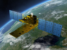
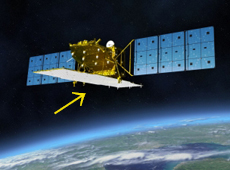
Computer image of ALOS-2
It felt really great to have my personal experience reflected in ALOS-2. After working on the Advanced Earth Observation Satellite (ADEOS) MIDORI, which launched in 1996, and the Advanced Land Observing Satellite (ALOS) DAICHI in 2006, I joined the effort to start up the ALOS-2 project. It was great to be able to bring all the experience from those first two satellites and test my ideas on how we could have done things better. That was a great motivator. I am really looking forward to the joy when we confirm that ALOS-2 is operating properly in space.
— If you were to give one example of something from your experience that was reflected in the project, what would it be?
The top mission priority for ALOS was not initially disaster observation. But after it began operating, the level of priority given to disaster observation increased, and one issue that came up was rapid response. How soon you can observe and provide information is important. To make ALOS-2 faster, we focused on creating an end-to-end chain of the total system. For example, when the satellite captures an image at the request of ground control and we get that data on the ground, each task is assigned to a different system. We also designed the process so that when we work with different manufacturers, there are no unnecessary barriers among systems. I think that with ALOS-2, we made this single big system capable of responding speedily as an end-to-end chain.
My first time witnessing a launch
— Is there anything you are particularly concerned about as project manager?

I think that a sense of speed is most important. I try to always keep my antenna up and respond swiftly when a problem occurs. I believe it’s important to be prepared and anticipate every possible risk.
— Tell us how you feel now, right before the launch.
I have somewhat mixed feelings, in that I know I have a responsibility to fulfill, but I also hope to see the launch. Until now I have always worked on ground-based systems, and had to wait there for data we needed to receive soon after launch. So I have never actually seen a satellite launch up close. This time I’ll experience my first launch at the Tanegashima Space Center, so I’m really looking forward to it. I am so very excited. And yet, I feel a great weight of responsibility. The launch absolutely has to succeed, because if we fail, there will be no story.
Shinichi Suzuki

Project Manager, Advanced Land Observing Satellite-2 (ALOS-2) Project Team, Satellite Applications Mission Directorate I, JAXA
Mr. Suzuki was involved in the development of Advanced Earth Observation Satellite (ADEOS) MIDORI, NASA’s Mars exploration program Mars Surveyor (as a visiting engineer at the Jet Propulsion Laboratory), and the Advanced Land Observing Satellite (ALOS) DAICHI. He has been with the ALOS-2 Project Team since 2009, and has held his current position since October 2013.
[ May. 23, 2014 ]