NOAA to utilize data acquired by "SHIZUKU"
September 5, 2014 (JST)
Japan Aerospace Exploration Agency (JAXA)
National Oceanic and Atmospheric Administration (NOAA)
The U.S. National Oceanic and Atmospheric Administration (NOAA) has begun to routinely utilize observational data acquired by the Advanced Microwave Scanning Radiometer 2 (AMSR2) aboard the Global Change Observing Mission - Water "SHIZUKU" (GCOM-W) to monitor the land, ocean and atmosphere globally and around the U.S. GCOM-W was launched by the Japan Aerospace Exploration Agency (JAXA) in May 2012 and JAXA started providing the AMSR data to NOAA in February, 2013. AMSR2, measuring weak microwave emissions from the Earth's surface through clouds data, can characterize storms to better and more precisely understand the internal structure, such as the eye of a hurricane. This summer NOAA also began testing these data in its numerical weather prediction system, which will improve the initialization of the forecast guidance models. In Japan, the AMSR2 data application into the Numerical Weather Prediction System by the Japan Meteorological Agency started last September to improve precipitation forecast accuracy.
Attachment
NOAA is studying the possibility of utilizing data acquired by the AMSR2 aboard the SHIZUKU as well as by the Dual-frequency Precipitation Radar (DPR) on the Global Precipitation Measurement (GPM) satellite. Both the AMSR2 and DPR are developed by JAXA, and JAXA and NOAA have been discussing cooperation on the projects. As a first step, AMSR2 data are regularly provided to the U.S. for weather forecast applications. NOAA’s recently signed Memorandum of Understanding (MOU) with the U.S. National Aeronautics and Space Administration (NASA) on the NASA-JAXA GPM mission will allow NOAA to receive the DPR data. As part of NOAA’s participation with NASA on the GPM Science Team, a few NOAA investigators are testing the feasibility of utilizing the space-borne radar information from DPR and its predecessor, the Precipitation Radar (PR) on the NASA-JAXA Tropical Rainfall Measuring Mission (TRMM) satellite, in regional forecast models to improve the forecasting of tropical systems.
AMSR2 aboard the SHIZUKU can measure weak microwave emissions from the Earth's surface through clouds, and the DPR on the GPM can observe rain and snow in 3D; thus, storms can be characterized to better and more precisely understand the internal structure, such as the eye of a hurricane, compared to what can be done using data from a visible infrared scanner aboard a geostationary satellite. Because of these advantages, these advanced instruments enable forecasters to more precisely predict the strength and direction of a hurricane or a typhoon.
NOAA evaluated the validity and accuracy of the AMSR2 data for observation of hurricanes and typhoons last year (*1). NOAA’s National Hurricane Center is now routinely utilizing AMSR2 data, which have contributed to improvements in the center location and structure analysis for a number of hurricanes as shown in Figure 1.
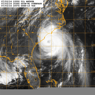
Infrared observation
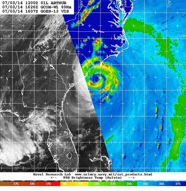
Microwave observation (GCOM-W/AMSR2)
Figure 1 Hurricane "Arthur" on July 3, 2014
The cloud image captured through infrared observation (left) cannot clarify the internal structure of a typhoon or hurricane, but the microwave observation (right) clearly shows the dual structure of the eye and surrounding rain bands of Hurricane Arthur off the U.S. East coast through its observation of horizontally polarized brightness temperature (89 GHz-H) being naturally emitted from the Earth's surface and the atmosphere. (Images provide by NOAA and Naval Research Laboratory)
In addition, NOAA started to directly receive data from AMSR2 at two data receiving stations in Wisconsin and in California on July 29 to more quickly gather and use the data. Through the above two stations, NOAA can immediately utilize data as soon as they are received. The direct reception of AMSR2 data at specific U.S. locations, agreed by NOAA and JAXA in 2013, expands NOAA-JAXA GCOM-W cooperation under a 2011 agreement through which NOAA provides ground data acquisition and communications support for GCOM-W in exchange for rapid access to AMSR2 data. Figure 2 shows an example of data received at the ground station in Wisconsin. Dr. Mitchell Goldberg, Chief Program Scientist of NOAA Joint Polar Satellite System (JPSS), commented as follows.
"The direct readout of GCOM-W AMSR2 data over US areas of interest is a major accomplishment for NOAA. AMSR2 data are used for many applications, including assessing the strength of hurricanes and typhoons. GCOM-W data will now be available in minutes instead of upwards of two hours, enabling the National Hurricane Center to have faster access to critical data used in forecasting extreme weather events that can have catastrophic impacts on lives and property."
NOAA plans to receive data directly at other stations in the U.S. in addition to the Wisconsin and California stations to monitor hurricanes and typhoons in the North Atlantic and the North Pacific Oceans.
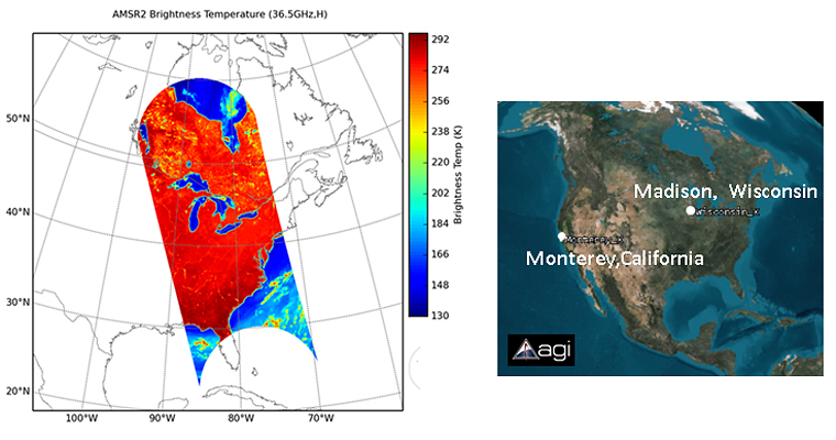
Figure 2 AMSR2 observation data successfully received at Wisconsin University on July 29, 2014
(provided by NOAA)
JAXA regularly provides the JMA with AMSR2 observation data which have already been utilized for daily weather forecasts and typhoon analysis. (*2)
(*1) http://www.nesdis.noaa.gov/news_archives/jaxa.html
(*2) https://www.jaxa.jp/press/2013/09/20130912_shizuku_j.html