Advanced Land Observing Satellite-2 "DAICHI-2" (ALOS-2)
Regular Provision of Observation Data
November 25, 2014 (JST)
Japan Aerospace Exploration Agency (JAXA)
The Japan Aerospace Exploration Agency (JAXA) began regular provision of the Advanced Land Observing Satellite-2 "DAICHI-2" (ALOS-2) observation data today as we have completed its initial functional confirmation and calibration operations as scheduled. The DAICHI-2 was launched on May 24, 2014. Data is expected to be utilized for understanding post-disaster situations, monitoring deforestation, and observing sea ice in the Sea of Okhotsk and Polar Regions. (Please referee to the attached.)
The ALOS-2 Data Distribution Consortium is the contact point for general users to receive DAICHI-2 observation data.
(Note)
The PALSAR-2 aboard the DAICHI-2 is the world's only satellite-onboard synthetic aperture radar using the L-band frequency that is currently in operation. It is suitable for observing forests and land deformation, and can acquire image data of the ground surface day and night regardless of the weather.
[Contact for general users]
ALOS-2 Data Distribution Consortium
- Remote Sensing Technology Center of Japan
URL:http://www.restec.or.jp/english/index.html - PASCO CORPORATION
Data search and order site:
URL:https://satpf.jp/
Data introduction site:
URL:http://en.alos-pasco.com/
Attachment
Improvement of resolution
Comparison of the DAICHI-2 Spotlight mode image (resolution 1m x 3m) and the DAICHI PALSAR image (resolution 10m). More details such as buildings are captured in the Spotlight mode image.

(June 20, 2014) Resolution 1m x 3m
(Sept. 21, 2010) Resolution 10m
Use for disaster monitoring
JAXA conducted emergency observations of Mt. Ontake's volcanic eruption that occurred on Sept. 27, 2014, using the DAICHI-2 according to a request from the Coordinating Committee for Prediction of Volcanic Eruptions (Secretariat: Japan Meteorological Agency) and the Cabinet Office (Disaster Management), and provided the acquired data. This observation and provision was reported at the Extream Disaster Management Headquarters for Mt. Ontake eruption in 2014, and the result of the interferometry analysis was reported at the Coordinating Committee for Prediction of Volcanic Eruptions.
The depression on the left of Jigokudani (Explosion Crater) in the post-eruption image (left) was considered to be newly made by the eruption this time.

In the colored synthetic image showing prior and post eruption status (left), observed changes are colored in purple. We can project that falling ash has accumulated and distributed around the volcanic crater at the peak of Mt. Ontake through satellite images.
The interferometry image (right) shows distance changes between the satellite and the ground (topographical changes) in color. The color of the area near Jigokudani (Explosion Crater, a circled area) changed from yellowish to reddish, and that was supposed to occur as the ground came closer to the satellite (or the land of the said area moved parallel to the west.)


Nishinoshima Island in Ogasawara has been growing since its volcanic eruption in Nov. 2013. We can confirm that its land area has been expanding over about five months through images taken by the DAICHI-2
 Nov. 9, 2014
 June 20, 2014
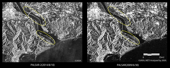
Due to torrential downpours from Typhoon No. 11, JAXA performed an emergency observation around noon on Aug. 10, 2014. We observed submergence of a shoal in the middle of the Niyodo River (Kochi city, Kochi Pref.) as well as its widened river width through the satellite images. We provided observation images regarding Typhoon No. 11 to the Ministry of Land, Infrastructure, Transport and Tourism, and the Kochi Municipal Government.
Use of data in Polar regions and oceans
Since 2006, the Japan Coast Guard has been regularly using the PALSAR aboard the DAICHI for its floating ice monitoring in the sea of Okhotsk. Data from the DAICHI-2 is scheduled to be utilized for ship navigation safety from winter 2014. The figures below show the condition of floating ice in the Arctic sea.

An estimation of the position, moving direction and speed of a ship from image data taken by the DAICHI-2. Compared to data acquired by the DAICHI, the noise level is smaller so that it becomes easier to understand ocean surface conditions.

Use for forest management
When comparing images taken by the DAICHI in 2010 and by the DAICHI-2 in 2014, we can understand changes in a forest area. We provide image data to Brazil for deforestation monitoring three to four days after observation.

At an event
During the open-house at the JAXA Earth Observation Center on Nov. 8, 2014, we held an event called "Let's become a subject of the DAICHI-2 image taking" to facilitate the use of the DAICHI-2. We formed a letter using men standing in a "H shape" with a hand-made reflection mirror and a silver mat and were successfully taken by the DAICHI-2. Similar events are scheduled to be hosted by organizations all over Japan including in South Tanegashima.
