Topics List
Feb. 18, 2020 Updated
Massive bushfires in Australia seen from Space
|
Australia has naturally faced many droughts and bushfires, but conditions have been unusually severe this time. Sometime around September 2019, the bushfires continuously occurred around the state of New South Wales in southeast Australia. The fires had been spreading on a larger scale, and a number of massive fires had merged into a "Mega Fire" that was out of control. The fires are unlikely to end entirely even at the end of January 2020. 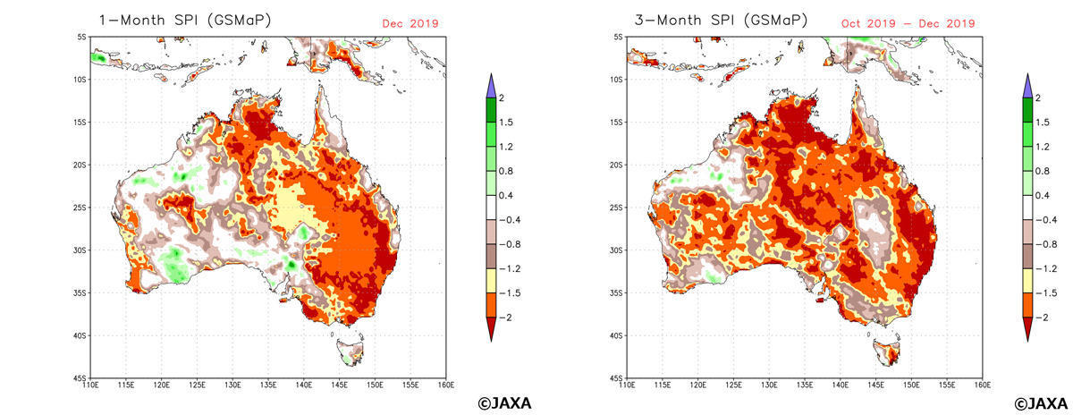
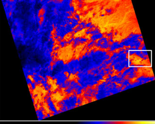
Figure 1 (left) Standardized Precipitation Index (SPI) in Australia calculated by GSMaP precipitation amount in a month (December 2019), (right)SPI calculated by GSMaP precipitation amount in three months (October-December 2019) in a same way. The relations between SPI value, the range of drought and frequency of phenomenon were classified by WMO (2012). In case SPI value becomes "-1.5 to -1.99", it indicates the situation of "Severe dryness" which happens "once in 20 years". In case SPI value becomes less than -2.0, it corresponds "Extreme dryness" which happens "once in 50 years". These condition shows the possibility of severe drought occurrence which leads to a big social impact. |
Apr. 19, 2018 Updated
JJ-FAST stops deforestation first time at rainy season in Brazil!
|
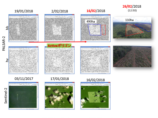
JJ-FAST team is developing a next-generation deforestation detection algorithm (version 2) to increase number of deforestation detection, and improve detection accuracy. To validate deforestation sites detected by the new algorithm, a JJ-FAST team visited some sites in Brazil on Feb. 22, 2018. When the team accompanied by IBAMA (Instituto Brasileiro do Meio Ambiente e dos Recursos Naturais Renovaveis) arrived at one site, a bulldozer was mowing down trees. Two forest loggers were caught red-handed, and the bulldozer was legally seized on site by IBAMA. The team and IBAMA officers also visited another site with ongoing deforestation on Feb. 26, 2018. When the team reached the site around noon, they found two large bulldozers connected with a massive metal chain left unattended. Bulldozers and chain mowing down trees is the typical method to clear-cut large areas quickly. Soon, three workers returned and stood in amazement when they found we waiting for them next to their bulldozers. The men were seized, and the machinery was confiscated on site by IBAMA. Being aware of the possible detection by optical satellites, they looked like they were wondering how their illegal deforestation activities were found under the cloud cover in rainy season. This validation activity was supported by two kind IBAMA researchers, Dr. Edson Sano and Dr. Daniel Freitas, and IBAMA local staffs in Sinop and Junia. The JJ-FAST team is very grateful for this wonderful cooperation with our counterparts in Brazil. |
|
|---|
Feb. 9, 2018 Updated
DAICHI-2 captures tanker oil spill in the East China Sea
|
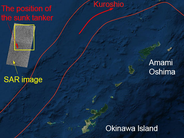
In January 6, 2018, Iranian company's tanker "SANCHI" (Panama flag) collided with a cargo ship (Hong Kong flag) in the East China Sea off the east coast of China and a fire broke out. The tanker drifted into Japan's exclusive economic zone (EEZ) not being extinguished and exploded and sank at the sea about 315 km west of Amami Oshima in the afternoon of 14th. Oil is draining from the sunk tanker. |
|
|---|
Jul. 25, 2017 Updated
ALOS-2 Captures Massive Iceberg's Breakoff from Antarctica
|
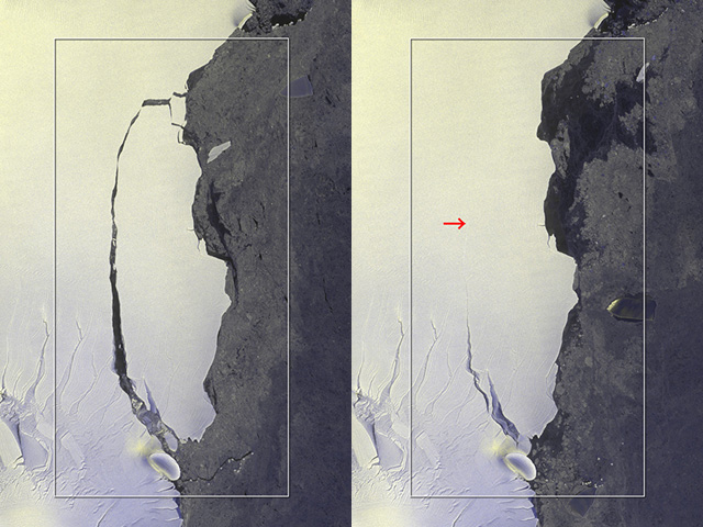
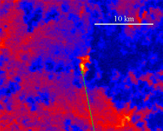
On July 12, 2017, an iceberg split off from Antarctica’s Larsen C iceberg. With use of ALOS-2’s wide-area observatory mode, JAXA was able to capture the entire calving image. |
|
|---|
Apr. 21, 2016 Updated
DAICHI-2 received the MEXT science and technology award
|
The Ministry of Education, Culture, Sports, Science and Technology (MEXT) recognizes remarkable achievements of R&D and the promotion of understanding in the science and technology field by presenting an award, the MEXT minister’s award in the field of science and technology. |
|
|---|
Mar. 17, 2016 Updated
DAICHI-2 honored by central emergency communications council
|
DAICHI-2 received an award for its contributions to anti-disaster operations by the council (*) on March 16, 2016. DAICHI-2 performs emergency observations in response to requests from disaster preparation agencies, and swiftly provides data to understand signs of disasters and their status. |
|
|---|
May 14, 2015 Updated
Agreement concluded with MLIT on DAICHI-2 observation data
|
JAXA concluded an agreement with the Kyushu Regional Development Bureau of the Ministry of Land, Infrastructure, Transport and Tourism (MLIT) on April 30, 2015, to provide observation data by the Advanced Land Observing Satellite-2 “DAICHI-2” (ALOS-2). The purpose of the agreement is to survey (1) secular changes of landscape and ash fall and (2) isolated islands for their up keep. We will work together to conduct surveys more efficiently with broader covering areas by mutually sharing and studying observation data possessed by the Kyushu Regional Development Bureau and JAXA's satellite data. |
|
|---|
Jan. 23, 2015 Updated
ALOS-2/CIRC data is open to public!
|
After the calibration and validation of ALOS-2/CIRC, JAXA confirmed the data quality of ALOS-2/CIRC is adequate. All ALOS-2/CIRC data is avaliable from CIRC observation data search, if user follows the CIRC data policy. |
|
|---|
Nov. 25, 2014 Updated
“DAICHI-2” Regular Provision of Observation Data
|
JAXA began regular provision of the Advanced Land Observing Satellite-2 “DAICHI-2” (ALOS-2) observation data today as we have completed its initial functional confirmation and calibration operations as scheduled. |
|
|---|
Sep. 30, 2014 Updated
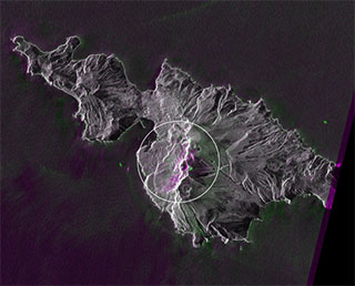
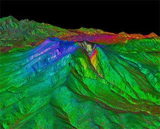
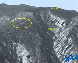
DAICHI-2 captured Mt. Ontake eruption
|
Mt. Ontake straddling Nagano and Gifu prefectures erupted at 11:52 a.m.
on Sept. 27, 2014. JAXA has been observing the volcanic activity and its
impact by earth observation satellites. The DAICHI-2 acquired data on
Mt. Ontake on Sept. 27, 28, and 29. As it started regular observation
operations in early August and captured some images of Mt. Ontake prior
to the eruption, we can compare images taken before and after the
incident to study changes and the situation. |
|
|---|
Aug. 11, 2014 Updated
First Image Data Acquisition by CIRC onboard DAICHI-2
|
Compact Infrared Camera (CIRC) is a technology demonstration payload onboard the DAICHI-2. CIRC is an infrared sensor intended for observing forest fires, volcanoes, and heat island phenomena. |
|
|---|
Jun. 27, 2014 Updated
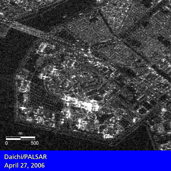
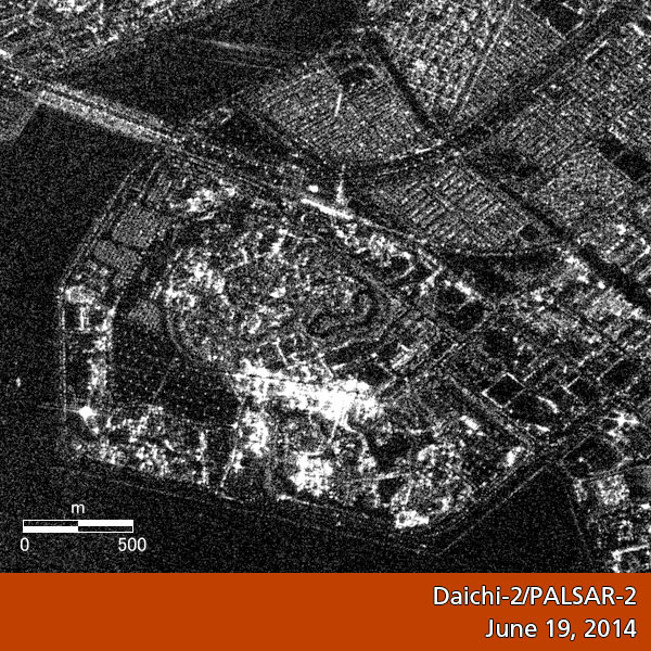
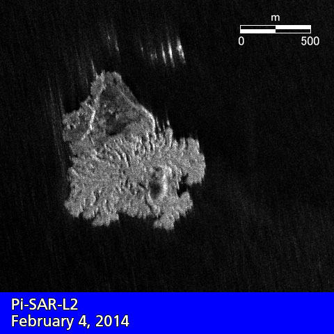
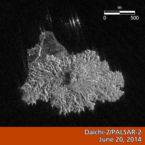
First Image Data from“DAICHI-2” (ALOS-2)
|
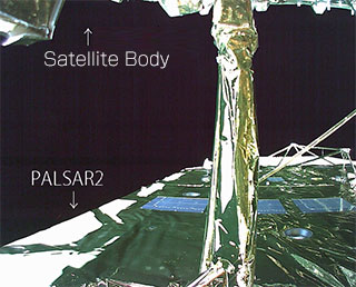
JAXA acquired images from the PALSAR-2 aboard the "DAICHI-2" (ALOS-2). Comparison of images taken by PALSAR-2 and DAICHI PALSAR (Urayasu City)
Comparison of images taken by PALSAR-2 and the synthetic aperture radar aboard airplane (Nishinoshima Island)
PALSAR-2 movies |
|
|---|
May 27, 2014 Updated
DAICHI-2 critical operation phase successfully completed! Initial function verification starts!
|
The DAICHI-2 launched from the Tanegashima Space Center on May 24 performed important tasks including L-band synthetic aperture radar deployment after its injection into the orbit, thus its critical operation phase was successfully completed. |
|
|---|
May 24, 2014 Updated
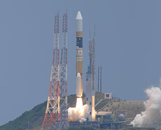
Successful launch of H-IIA F 24 with DAICHI-2 (ALOS-2)!
|
The launch of the H-IIA Launch Vehicle No. 24 with The Advanced Land Observing Satellite-2 "DAICHI-2" (ALOS-2) aboard was successfully performed at 12:05:14 p.m. on May 24 (Sat.) 2014 (Japan Standard Time). |
|
|---|
May 22, 2014 Updated
DAICHI-2/H-IIA F24 to be launched soon! Live broadcast from 11:15 a.m. on May 24 (Sat.)
|
The launch time of the H-IIA Launch Vehicle No. 14 (H-IIA F14) with the
DAICHI-2 onboard was set for 12:05:14 p.m. on May 24 (Sat.) 2014 (Japan
Standard Time). |

|
|---|
May 1, 2014 Updated
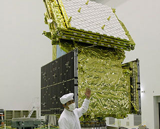
DAICHI-2 (ALOS-2) revealed to the media at TNSC
|
On March 28 (Fri.), the Advanced Land Observing Satellite-2 “DAICHI-2”(ALOS-2) was revealed to the press at the Spacecraft Test and Assembly Building 2 (STA-2) at the Tanegashima Space Center (TNSC.)
|
|
|---|
Mar. 31, 2014 Updated
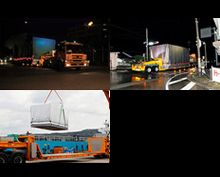
DAICHI-2 (ALOS-2) transportation to Tanegashima
|
We would like to report to you the transportation of the DAICHI-2 (ALOS-2) from the Mitsubishi Electric's Kamakura Works, where its assembly and tests were conducted, to the Tanegashima Space Center (TNSC). |
|
|---|
Mar. 14, 2014 Updated
Launch date set for DAICHI-2 on H-IIA F24!
|
The launch date and time for the H-IIA Launch Vehicle No. 24 (H-IIA F24) with the Advanced Land Observing Satellite-2 "DAICHI-2" (ALOS-2) onboard was decided to be at around 12:05 p.m. thru 12:20 p.m. (JST) on May 24 (Sat.,) 2014 (Japan Standard Time.) |

|
|---|
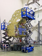
Oct. 17, 2012 Updated
Advanced Land Observing Satellite-2: System thermal vacuum test
|
The thermal vacuum test for the Advanced Land Observing Satellite-2 "ALOS-2" started on Oct. 16th at the Tsukuba Space Center. It is scheduled to be completed in late November. |
|
|---|
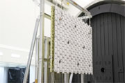
Apr. 18, 2012 Updated
PALSAR-2 impulse response evaluation under vacuum environment
|
From March 5 to 9, JAXA conducted impulse response evaluation of the Phased Array type L-band Synthetic Aperture Radar (PALSAR-2) aboard Advanced Land Observing Satellite-2 (ALOS-2) under vacuum environment in 6-Meter-Diameter Radiometer Space Chamber Building at the Tsukuba Space Center. |
 |
|---|