Aug. 12, 2016 Updated
AJISAI marked 30th anniversary on Aug. 13, 2016, and its operation still continues
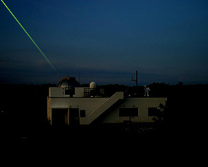
The Experimental Geodetic Satellite "AJISAI" (EGS)" was launched at 5:45 a.m. on Aug 13, 1986 (JST) from the Tanegashima Space Center and it was put into a circular orbit at an altitude of 1,500 km by the maiden H-I Launch Vehicle.
AJISAI is the first Japanese geometric satellite, and its major missions are rectifying Japan's domestic geodetic triangular net -- determining the exact position of many isolated Japanese islands and establishing Japan's geodetic point of origin. AJISAI is a ball-shaped satellite, 2.15 meters in diameter and weighing about 685 kilograms. Its surface is covered with 1,486 prisms and 318 reflectors. Satellite Laser Ranging (SLR) stations around the world are observing AJISAI using laser pulse. The SLR system at JAXA’s Masuda Tracking and Communications Station also keeps monitoring AJISAI. Researchers around the world highly evaluate the 30-year long operation and precious observation data of AJISAI.
|
|
May 26, 2011 Updated
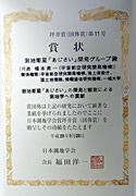
AJISAI received the Tsuboi Prize of the Geodetic Society of Japan (Group Prize)
The 25-year operation and precious observation data of the Experimental Geodetic Satellite "AJISAI" (EGS) was highly evaluated by the Geodetic Society of Japan, and, on May 23, 2011, the Tsuboi Prize (Group Prize) was awarded to a group led by former space verification team project manager Eiichi Hashimoto. The group consists of JAXA, the National Institute of Information and Communications Technology (NICT), the Japan Coast Guard (JCG), Geospatial Information Authority of Japan (GSI), and Hitotsubashi University. The AJISAI was launched on August 13, 1986, to establish the Japan's geodetic datum. The Tsuboi Prize of the Geodetic Society of Japan (Group Prize) is awarded to a group that has made outstanding contributions to geodetic studies as organizational activities are particularly important for geodetic research.
AJISAI's major achievements
- Contributions to updating a nautical chart of Japan's neighboring waters and determining locations of islets (JCG's original objectives)
- Communications and positioning experiments and technological developments (NICT, Hitotsubashi Univ.)
- Research on satellite rotation (GSI)
- Acquired technology for accurate orbit determination by laser ranging (JAXA)
- Decided the 36th to 50th gravity field model (world research institutes, such as Jet Propulsion Laboratory, JPL, and Deutsches Zentrum für Luft- und Raumfahrt, DLR)
- Contributed to construct the International Terrestrial Reference Frames (ITRF)
- Determined the absolute value of the velocity field for plate tectonics motion thanks to the long-term motion analysis of 25 years by the AJISAI
- Recently verified that the core inside the Earth is vibrating through the analysis combined with the LAGIOS1/2 . The result of the verified fact was incorporated into the new earth rotation model (IERS2010.)
|
|
Apr. 12, 2011 Updated
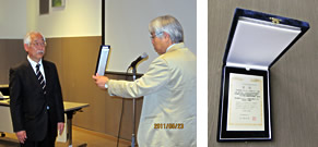
AJISAI received a letter of appreciation from ILRS
The Experimental Geodetic Satellite “AJISAI” (EGS) was launched on Aug.13, 1986, to confirm and establish Japan’s geodetic datum. After almost 25 years since its launch, the AJISAI received a letter of appreciation from the International Laser Ranging Service (ILRS) on March 8, 2011.
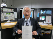
The AJISAI has been observing the Earth for such a long time to contribute to various fields including mapping nautical charts (Japan Coast Guard), communication and positioning experiments and technological development (National Institute of Information and Communications Technology), research on rotation of satellites (Geospatial Information and Authority of Japan), and acquisition of precision orbit determination technology by laser ranging (JAXA), as well as the determination of about the 36th to 50th gravity field model (world research institutes.) Above all, AJISAI’s observations were very helpful for the long-term analysis of the Earth's movement. AJISAI was, therefore, highly evaluated by the ILRS, which supports the world’s geodetic science, for its scientific and international significance and its technological ability through its long-term observations and research. On March 8, 2011, the 25th operation and liaison meeting for the EGS was held at JAXA’s Masuda Tracking and Communication Station (in Tanegashima,) and Hidekazu Hashimoto (from JAXA Space Technology Demonstration Research Center), who is one of the developers of the AJISAI, gave a lecture about its development and scientific achievements over 25 years, and received a letter of appreciation from the ILRS.
|
|