Topics List
Mar. 4, 2021 Updated
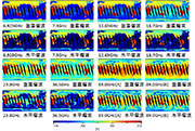
GSMaP receives "Dr. Roman L. Kintanar Award 2020" for significant contribution to Typhoon Committee's regional flood forecasting
|
The joint team of the International Centre for Water Hazard and Risk Management (ICHARM), the Infrastructure Development Institute (IDI) and JAXA was given the “Dr. Roman L. Kintanar Award for Typhoon-Related Disaster Mitigation - 2020”. The Dr. Roman L. Kintanar Award is given annually to an organization that has made a significant contribution to the activities of the Typhoon Committee, an inter-governmental body established under the United Nations Economic and Social Commission for Asia and the Pacific (ESCAP) and the World Meteorological Organization (WMO) to reduce the damage caused by typhoons. JAXA has developed the Global Satellite Mapping of Precipitation (GSMaP). The GSMaP has contributed significantly to flood prediction in the Typhoon Committee Region. This is the first time that Japanese organizations, other than the Japan Meteorological Agency, got the award. 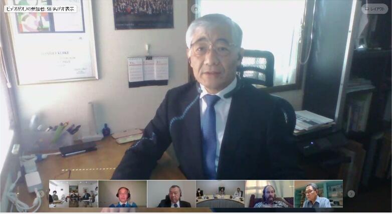
Acceptance speech by ICHARM Executive Director KOIKE at the 53rd session of the 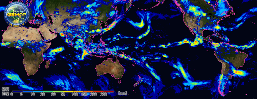
The GSMaP is a global rainfall map developed by combining the multi satellites under the Global Precipitation Measurement (GPM) mission. The users have spread to 138 countries in the world, and the GSMaP is being used in various fields such as precipitation monitoring, flood forecasting, drought monitoring, agriculture, and so on.
|
Feb. 18, 2020 Updated
Massive bushfires in Australia seen from Space
|
Australia has naturally faced many droughts and bushfires, but conditions have been unusually severe this time. Sometime around September 2019, the bushfires continuously occurred around the state of New South Wales in southeast Australia. The fires had been spreading on a larger scale, and a number of massive fires had merged into a "Mega Fire" that was out of control. The fires are unlikely to end entirely even at the end of January 2020. 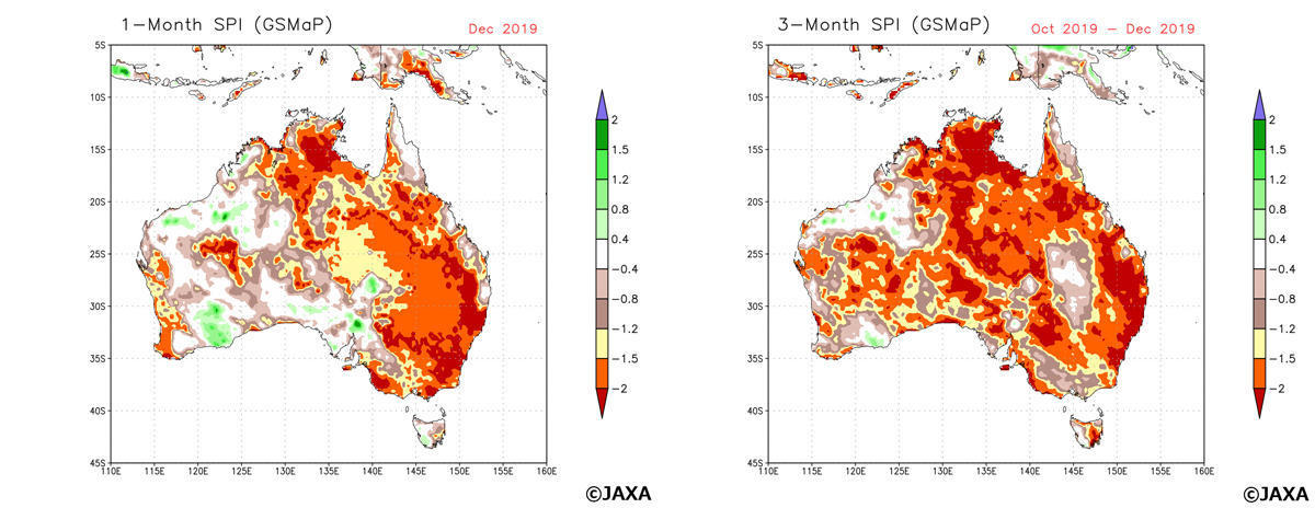
Figure 1 (left) Standardized Precipitation Index (SPI) in Australia calculated by GSMaP precipitation amount in a month (December 2019), (right)SPI calculated by GSMaP precipitation amount in three months (October-December 2019) in a same way. The relations between SPI value, the range of drought and frequency of phenomenon were classified by WMO (2012). In case SPI value becomes "-1.5 to -1.99", it indicates the situation of "Severe dryness" which happens "once in 20 years". In case SPI value becomes less than -2.0, it corresponds "Extreme dryness" which happens "once in 50 years". These condition shows the possibility of severe drought occurrence which leads to a big social impact. |
Jul. 26, 2017 Updated
Huge Iceberg Breaks away from Antarctic Ice Sheet — Shizuku Satellite Observations Detect
|
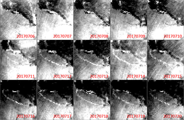
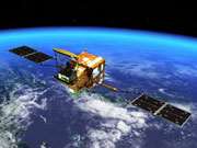
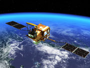
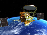
An iceberg about the size of Mie Prefecture of Japan split off from Antarctica’s Larsen C iceberg on July 12, 2017. The second Advance Microwave Scanning Radiometer (AMSR2) on JAXA’s Shizuku satellite captured the calving of the close to 5,800-square kilometer chunk of ice. The nascent iceberg created by the rift is estimated to weigh over a trillion ton kilograms.
|
|
|---|
Feb. 21, 2017 Updated
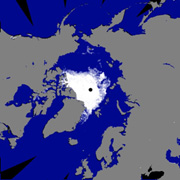
GCOM-W: Sea Ice Hits Record Low
|
Global sea ice extent hit record low, according to observations from Shizuku on Global Change Observation Mission on January 14, 2017. It is all time low in the history of satellite operation that started in 1978, JAXA continues operation of Shizuku and GCOM-C and monitoring arctic sea ice extent, off the coast of Greenland Sea and the rest of the arctic circle. |

|
|---|
Nov. 2, 2015 Updated
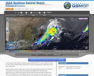
Release of the JAXA Realtime Rainfall Watch
|
Earth Observation Research Center (EORC) of Japan Aerospace Exploration Agency (JAXA) has developed GSMaP realtime version (GSMaP_NOW) providing rainfall information of current hour, and released those information through a new webpage “JAXA Realtime Rainfall Watch”. |
|
|---|
Sep. 5, 2014 Updated
NOAA to utilize data acquired by "SHIZUKU"
|
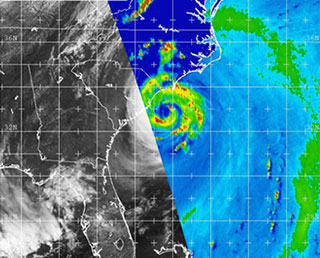
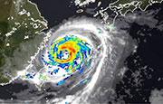
The U.S. National Oceanic and Atmospheric Administration (NOAA) has
begun to routinely utilize observational data acquired by the Advanced
Microwave Scanning Radiometer 2 (AMSR2) aboard the Global Change
Observing Mission - Water "SHIZUKU" (GCOM-W) to monitor the land, ocean
and atmosphere globally and around the U.S. GCOM-W was launched by the
Japan Aerospace Exploration Agency (JAXA) in May 2012 and JAXA started
providing the AMSR data to NOAA in February, 2013. Image: Hurricane "Arthur" on July 3, 2014 |
|
|---|
Feb. 3, 2014 Updated
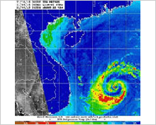
NOAA utilizes SHIZUKU data for typhoon monitoring
|
The National Oceanic and Atmospheric Administration (NOAA) announced that it will utilize observation data acquired by the Advanced Microwave Scanning Radiometer 2 (AMSR2) aboard the Global Change Observation Mission 1-Water “SHIZUKU” (GCOM-W1) from June 1, 2014, to monitor the birth and development of a tropical low pressure system. |
|
|---|
Oct. 17, 2013 Updated
SHIZUKU receives Nikkei Global Environmental Technology Awards Prize for Excellence!
|
The Global Change Observation Mission 1st - Water "SHIZUKU" (GCOM-W1) captured the 2013 Nikkei Global Environmental Technology Awards Prize for Excellence. The awards are sponsored by Nikkei Inc. to be given to individuals and groups who have made outstanding contributions to environmental preservation. |
 |
|---|
May 17, 2013 Updated
SHIZUKU to provide geophysical quantity products
|
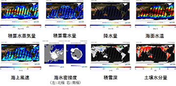
On May 17, 2013, JAXA started offering eight kinds of products whose physical quantity concerning water on the Earth, including precipitable water in the atmosphere and sea surface temperature, is calculated based on the observation data acquired by the Advanced Microwave Scanning Radiometer 2 (AMSR2) aboard the Global Change Observation Mission 1st-Water “SHIZUKU” (GCOM-W1).
|
|
|---|
Jan. 25, 2013 Updated
SHIZUKU to Provide Brightness Temperature Products
|
JAXA has started offering brightness temperature products*1 from the onboard Advanced Microwave Scanning Radiometer 2 (AMSR2) of the Global Change Observation Mission 1st - Water "SHIZUKU" (GCOM-W1), after its initial calibration operation*2 was completed. |
 |
|---|
Dec. 25, 2012 Updated
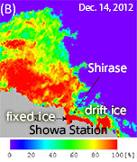
SHIZUKU provides ocean ice data to JARE
|
JAXA has been offering ocean ice data to the Japanese Antarctic Research Expedition (JARE) since Dec. 1, 2012. |
 |
|---|
Oct. 1, 2012 Updated
SHIZUKU cooperates with MIRAI on Arctic Ocean investigation and observations
|
JAXA and the Japan Agency for Maritime-Earth Science and Technology (JAMSTEC) are collaborating in the Earth environment field by combining space and oceanic technologies such as merging data acquired by an Earth observation satellite and on-the-spot data obtained through an observation system deployed in the ocean. |
 |
|---|
Sep. 20, 2012 Updated
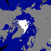
New record set on Sept. 16 for lowest level of Arctic sea ice
|
As a result of our analysis on sea ice data measured by the onboard microwave scanning radiometer aboard the Global Change Observation Mission 1st - Water "SHIZUKU,” Arctic sea ice levels shrunk to 3.49 million square kilometers, the smallest record in observation history. |
 |
|---|
Aug. 25, 2012 Updated
Arctic sea ice became smallest according to SHIZUKU observation data
|
As a result of JAXA’s analysis on sea ice data measured by the onboard microwave scanning radiometer of the “SHIZUKU,” which has been observing the Earth, we confirmed that the sea ice extent in the Arctic Ocean has become the smallest this year in observation history. The extent on August 24 (JST) was 4.21 million square kilometers, and that fell below the smallest record of 4.25 million square kilometers marked in 2007 in satellite observation history. |
 |
|---|
Aug. 10, 2012 Updated
"SHIZUKU" (GCOM-W1) Regular Observation Operations
|
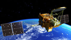
JAXA completed the initial functional verification of the Global Change Observation Mission 1st - Water "SHIZUKU" (GCOM-W1) and has moved to the regular observation operation on August 10 as scheduled. The SHIZUKU was launched by JAXA from the Tanegashima Space Center on May 18, 2012. |
 |
|---|
Jul. 4, 2012 Updated
SHIZUKU onboard sensor (AMSR2) acquired observation data!
|
SHIZUKU onboard sensor (AMSR2) acquired observation data! JAXA acquired observation data on the Earth from the Global Change Observation Mission 1st - Water "SHIZUKU" (GCOM-W1). The SHIZUKU was launched on May 18, 2012 (Japan Standard Time) from the Tanegashima Space Center and started regular observations by the onboard sensor, Advanced Microwave Scanning Radiometer 2 (AMSR2,) on July 3 after entering into the A-train orbit on June 29. The data was acquired by the AMSR2. We will continue the initial functional verification, then confirm data accuracy and perform initial calibration and inspection operations including data correction. |
 |
|---|
Jul. 2, 2012 Updated
SHIZUKU inserted into A-Train orbit!
|
JAXA confirmed that the Global Change Observation Mission 1st - Water “SHIZUKU” was inserted into a planned position on the A-Train orbit. The SHIZUKU was launched by the H-IIA Launch Vehicle No. 21 from the Tanegashima Space Center on May 18. |
 |
|---|
May 19, 2012 Updated
SHIZUKU critical phase completed!
|
The Global Change Observation Mission 1st - Water "SHIZUKU", which was launched from the Tanegashima Space Center on May 18, completed its critical operations as it was successfully inserted into the initial orbit and finished the AMSR2 run-up and other essential events normally. JAXA will take about 45 days to insert the satellite into the "A-Train orbit" in order to participate in an Earth observation mission called the "A-Train" in cooperation with satellites of other countries while performing the initial functional confirmation for about three months. |
 |
|---|
May 18, 2012 Updated
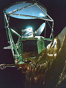
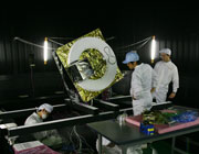
SHIZUKU's AMSR2 antenna successfully deployed
|
The Global Change Observation Mission 1st - Water "SHIZUKU" successfully deployed its onboard Advanced Microwave Scanning Radiometer 2 (AMSR), and the scene was shot by an onboard camera. The AMSR2 measures electromagnetic waves called microwaves emitted from nature such as the ground and ocean surface. It is an important sensor that observes water such as precipitation, vapor volume and the depth of snow. |
 |
|---|
May 18, 2012 Updated
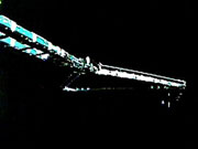
SHIZUKU: Successful solar array paddle deployment and initial orbit insertion
|
The Global Change Observation Mission 1st - Water "SHIZUKU" captured its successful solar array paddle deployment by an onboard camera over Australia. After SHIZUKU's orbit calculation, JAXA confirmed that the satellite was injected into the scheduled initial orbit. The SHIZUKU will deploy its onboard Advanced Microwave Scanning Radiometer 2 (AMSR). |
 |
|---|
May 18, 2012 Updated
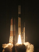
Successful launch of H-IIA F 21 with SHIZUKU and SDS-4 aboard!
|
The launch of the H-IIA Launch Vehicle No. 21 with The Global Change Observation Satellite 1st - Water "SHIZUKU" and Small Demonstration Satellite-4 (SDS-4) aboard was successfully performed at 1:39 a.m. on May 18 (Fri.) 2012 (Japan Standard Time). The launch vehicle flew normally and separated the SHIZUKU at about 22 minutes and 59 seconds after liftoff. Then, the Small Demonstration Stellite-4 (SDS-4) was also confirmed to be successfully separated as scheduled. The SHIZUKU will conduct critical phase operations including deploying the AMSR2 antenna. We await your support messages! |
 |
|---|
May 14, 2012 Updated
SHIZUKU Launch Live broadcast to start at 1:10 a.m. on May 18!
|
The Global Change Observation Mission 1st-Water “SHIZUKU” will be launched this weekend, at 1:39 a.m. on May 18 (Fri.) from the Tanegashima Space Center. JAXA will broadcast the live launch report from around 1:10 a.m. on May 18. You can watch it through some cable TV stations or websites, and via cell phones and smart phones. Please watch the SHIZUKU launch with us in real time! |
 |
|---|
May 1, 2012 Updated
SHIZUKU mated with the Payload Attach Fitting
|
On April 26, the Global Change observation Mission 1st-Water "SHIZUKU" was mounted onto the payload adapter called the "Payload Attach Fitting," or PAF, at the Spacecraft and Fairing Assembly Building at the Tanegashima Space Center. The PAF is a connection part between the satellite and the launch vehicle. The launch site operations are smoothly in progress, and the SHIZUKU will be covered by the fairing and loaded onto the launch vehicle. |
 |
|---|
Apr. 4, 2012 Updated
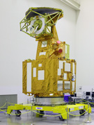
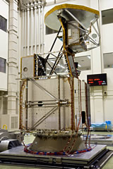
SHIZUKU revealed to the media at TNSC
|
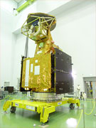
On April 4, the media was invited to have a look at the Global Change Observation Mission 1st-Water “SHIZUKU” at the Tanegashima Space Center. |
 |
|---|
Mar. 21, 2012 Updated
Launch date set for SHIZUKU & SDS-4 on H-IIA F21! Special site now available!
|
The launch date and time for the H-IIA Launch Vehicle No. 21 (H-IIA F21) with the Global Change Observation Mission 1st - Water "SHIZUKU" (GCOM-W1) onboard was decided to be at around 1:39 a.m. on May 18 (Fri.,) 2012. The Small Demonstration Satellite-4 (SDS-4) will also be launched by the H-IIA F21 as a secondary payload. |
 |
|---|
Jan. 12, 2012 Updated
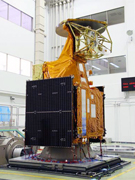
SHIZUKU revealed to the media
|
On Jan. 10, the media was invited to have a look at the Global Change Observation Mission 1st- Water “SHIZUKU” at the Tsukuba Space Center. |
 |
|---|
Sep. 21, 2011 Updated
'Shizuku' selected as nickname for Global Change Observation Mission 1st– Water (GCOM-W1)
|
JAXA conducted a nickname contest for about two months for the Global Change Observation Mission 1st – Water (GCOM-W1) satellite, and we received 20,998 applications. Among them, "Shizuku" (meaning a "drop"or a "dew") which was suggested by the largest number of people was selected. The typical reasoning for picking "Shizuku" was that the satellite will observe water circulation, which originated from a "drop" of water that becomes rain, then runs into the ocean, and ultimately evaporates in the air and becomes ice. This explanation gained high points during the selection process as it precisely illustrates the GCOM-W1 mission. JAXA will send a certificate and commemorative present to all of you who proposed the name "Shizuku." |
 |
|---|
Feb. 7, 2011 Updated
Global Change Observation Mission 3rd Research Announcement
|
JAXA is announcing the third research announcement (RA), which is the opportunity to conduct algorithm development, validation, and application research for the first satellite of the GCOM-W (Water) series, GCOM-W1, as well as multi-sensor research mainly using data from GCOM-W1. |
 |
|---|
Jan. 21, 2011 Updated
GCOM-W1: Sinusoidal vibration test of the protoflight model
|
JAXA conducted a sinusoidal vibration test of the GCOM-W1 protoflight model at the Tsukuba Space Center. |
 |
|---|
Nov. 26, 2010 Updated
EMC test by the protoflight model
|
The Advanced Microwave Scanning Radiometer 2 (AMSR2) on-board Global Change Observation Mission 1st - Water (GCOM-W1) will observe minute radio waves from the Earth. In order to verify that no other onboard electronic devices negatively affect AMSR2 function inside the?satellite when they are actually turned on, the electormagnetic?compatibility test was conducted at the Tsukuba Space Center (TKSC.)  |
|
|---|
Aug. 10, 2010 Updated
AMSR2 protoflight model antenna rotation test
|
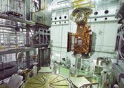
An antenna rotation test using a protoflight model (PFM) of the Advanced Microwave Scanning Radiometer 2 (AMSR2) was held at the Tsukuba Space Center. The AMSR2 will be loaded onto the GCOM-W1. The AMSR2's sensor unit rotates 40 times a minute in space, and it observes a swath of about 1,450 km on the ground surface per rotation. We had some limitations in simulating the impact of air resistance and the zero-gravity environment of space due to simulator restrictions for the ground test, thus the rotation speed was reduced to one tenth. Through the test, the rotation was verified to be normal. 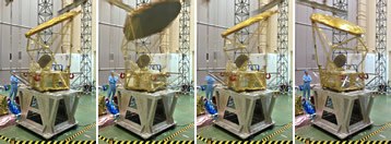 |
|
|---|
Aug. 4, 2010 Updated
AMSR2 protoflight model antenna deployment test
|
An antenna deployment test using a protoflight model of the Advanced Microwave Scanning Radiometer 2 (AMSR2) was held at the Tsukuba Space Center (TKSC.) The AMSR2 will be loaded onto the GCOM-W1. The antenna will be stowed when the GCOM-W1 is launched, and about 11 hours after the launch, bolts will be cut by pyrotechnics and the antenna will be deployed by a spring attached to the joint part of the strut. During the test, the impact caused by the antenna deployment was proved to be less than the specified level. We also confirmed that the deployment was successfully performed under the circumstance which simulates zero gravity in space. 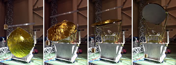 |
|
|---|
Mar. 10, 2010 Updated
Symposium of "Expectations to the Climate Change Monitoring using Earth Observation Satellites"
|
The Japan Aerospace Exploration Agency (JAXA) is holding a symposium titled "Expectations for Climate Change Monitoring using Earth Observation Satellites" on April 15, (Thursday) 2010, at the Hotel Pacific Tokyo. |
 |
|---|
Dec. 3, 2008 Updated
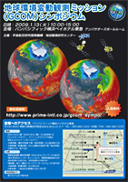
Global Change Observation Mission (GCOM) Symposium
|
At this symposium, JAXA and the organizations concerned report a background, a purpose, and a role of the GCOM plan, and the present status of the climate change research by the satellite observation. JAXA holds this symposium so that participants can understand the GCOM plan and the global environment issues. |
 |
|---|
Oct. 2, 2008 Updated
GCOM-W1 Sinusoidal Vibration Test
|
The GCOM project team performed the Sinusoidal Vibration Test on the GCOM-W1 structural model. The test aimed at verifying if the satellite's structural materials and its onboard equipment could withstand sinusoidal vibrations by simulating rocket launch vibrations. |
 |
|---|
Aug. 4, 2008 Updated
Thermal Vacuum Test with solar light was performed on Engineering Model of the high-temperature noise source (HTS) for the AMSR2
|
A Thermal Vacuum Test using solar light on the Engineering Model of the HTS for the Advanced Microwave Scanning Radiometer 2 (AMSR2) to be aboard the Global Change Observation Mission 1st - Water (GCOM-W1) was performed in the 8M Chamber Building at Tsukuba Space Center from July 30 to August 4, 2008. This test was to check if the sensor works normally after it was exposed to the constant solar light by placing a model of the sensor to be aboard the satellite in a chamber simulating the space environment. |
 |
|---|
Jan. 21, 2008 Updated
Global Change Observation Mission 1st Research Announcement
As the first step in a series of the Global Change Observation Mission (GCOM) research announcements (RAs), the Japan Aerospace Exploration Agency (JAXA) announces the opportunity to conduct research activities directly related to retrieval algorithms for geophysical products, product validation, and data application of GCOM-W1. Participation in this RA is open to all categories of domestic and foreign organizations including educational institutions (except for students), industries, non-profit institutions and Japanese Government agencies.