Q. What kind of work do you do in Indonesia?
I am a staff researcher at the Remote Sensing Technology Development Division of National Institute of Aeronautic and Space (LAPAN). Our work includes research and development of remote sensing technology: observation instruments, data processing, and ground stations that receive Earth observation satellite data.
Q. Can you explain your involvement in the STAR project?
LAPAN has a long history of cooperation with JAXA through meetings of the Asia-Pacific Regional Space Agency Forum (APRSAF). I attended APRSAF-13 in Jakarta in 2006, and have been following the activities of the organization since then. In 2007, a senior researcher at LAPAN participated in the first STAR project workshop, where the program was introduced and explained us. It was very interesting! Sometime later, my chief ordered me to participate in this program. I was assigned to learn from JAXA researchers about the development of electro-optical sensors for remote sensing applications.
It is an honor to participate in the STAR program and to have an opportunity to cooperate with JAXA staff and participants from other space agencies in the Asia Pacific region. This is my first time in Japan, and I've found JAXA staff to be very helpful in both the technical and social aspects.
It is an honor to participate in the STAR program and to have an opportunity to cooperate with JAXA staff and participants from other space agencies in the Asia Pacific region. This is my first time in Japan, and I've found JAXA staff to be very helpful in both the technical and social aspects.
Q. What kind of space development is Indonesia doing?
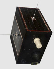
Indonesian Earth observation satellite LAPAN-TUBSAT (Courtesy of LAPAN)
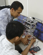
Studying a small-scale satellite system at JAXA.
Indonesia is developing microsatellites and rockets. The first LAPAN satellite, called LAPAN-TUBSAT, was developed by Indonesian engineers and launched in January 2007. It is still in operation. LAPAN-TUBSAT has two cameras, one high-resolution, and one low-resolution. Its dimensions are approximately 45 x 45 x 27 cm. It's a joint project of two countries: Indonesia and Germany. The transfer of knowledge, skill and experience in microsatellite technology is from Technische Universität Berlin, Germany and the German Aerospace Center.
Right now, LAPAN is working on its next microsatellite, the LAPAN-A2, which is based on LAPAN-TUBSAT. The LAPAN-A2 has an enhanced imaging device - a high definition video surveillance camera - and better positioning stability than its predecessor. The other project is an amateur radio microsatellite for experimental radio communication use. This is a joint project with the Organization of Amateur Radio in Indonesia.
Other Indonesian space research involves rocket vehicles, which we started developing back in the 1960s. Now Indonesia, is developing the RX-420 solid-fuel rocket. The RX-420 is Indonesia's proposed satellite launching rocket, which will carry our first indigenous Earth observation satellite into low-Earth orbit in 2014. RX-420 has a diameter of 42 cm. In addition, Indonesia is launching sounding rockets, which are small rockets for observing the upper atmosphere.
Q. How do you plan to use the technologies in the STAR project to benefit Indonesia in the future?
I know the STAR project has two programs, EO-STAR, focusing on Earth observation satellite systems (300 to 500 kg), and Micro-STAR, studying the development of microsatellites (50 to 100 kg).
I expect that both these programs will help us improve our knowledge of satellite technology and our capability to develop and build more advanced Earth Observation satellites.
Indonesia is an archipelago extending more then 5,000 kilometers from east to west and 1,760 kilometers from north to south. Our country has a lot of potential in land, water and mineral natural resources. At the same time, Indonesia is located near the equator, in the Pacific Ring of Fire, and consequently suffers a lot of water and geological disasters. I hope that the design, integration, testing and data utilization of the EO-STAR mission will help us in both these areas. EO-STAR can image all of Indonesia and contribute to investigating resources and reducing damage from natural disasters.
We can use the technical experience we gain from the Micro-STAR program in satellite development in Indonesia in the future. Hopefully we can build bigger satellites than a microsatellite. And, our Earth observation satellite will be of use to all of Asia as well as our own country.
Q. How would you describe the cooperation among space agencies in the Asia Pacific region? What are Indonesia's hopes and expectations for space development?
With the cooperation we've established, each country can exchange information and discuss collaboration in Earth observation. I think cooperation between our space agencies helps all of our countries to monitor and protect the region, and helps develop our human resources and improve our capability. Earth observation can help lessen damage from natural disasters, and can also be put to practical use in fields such as agriculture, forestry, land use, fishery, weather observation, air-pollution monitoring, etc. So, if cooperation among Asian space agencies is strengthened, I expect the lives of Asian people will be improved.
I hope that Indonesia can make great gains as a result of our regional cooperation in space science, and contribute to many projects such as the sharing and distribution of remote-sensing data, disaster monitoring and mitigation, satellite development, and other space technology.
Q. What are your expectations for cooperation with JAXA?
I expect that JAXA will continue to improve satellite technology and its application, and will continue to offer their know-how through the transfer of satellite technology to other space agencies in the Asia Pacific region. And on our part, we also want to make an effort to improve our technology.
Rahmat Arief
Staff Researcher, Remote Sensing Technology Development Division, National Institute of Aeronautics and Space (LAPAN), Indonesia
Mr. Arief studied in Germany, graduating in electronic engineering at the Georg-Simon-Ohm University of Applied Science in 2002, and receiving an M.Sc. from Kassel University in 2005. He joined LAPAN in 1993, and is now engaged in the development of payload systems for remote sensing satellites and of ground station systems.
Linking Asia to Tackle Disaster and Environmental Issues
Participating in the Human Resources Project STAR
Observing Earth's Environment from Space: Expectations for the SAFE Project
Participating in the Human Resources Project STAR
Observing Earth's Environment from Space: Expectations for the SAFE Project