Prediction of Wake Turbulence to Reduce Aircraft Separations at Take-Offs and Landings
— What is weather information technology?
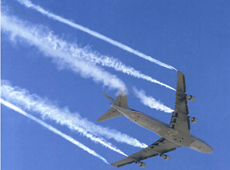 Wake turbulence (courtesy: NASA)
Aircraft operations are greatly affected by meteorological phenomena. In the DREAMS Project, we have developed technologies to reduce these impacts by predicting the risks of wake turbulence and low-level turbulences. Wake turbulence is a vortex that forms behind an aircraft in the air. Imagine something like a tornado stretching horizontally for at least 10 km. Wake turbulence remains in place for two to three minutes. It would be very hazardous if another aircraft encountered such a vortex, as it would lose control.
Meanwhile, low-level turbulence is a phenomenon in which wind shear (unexpected wind change) or turbulence is generated when air flow over a runway is drastically altered because of the terrain or buildings around the airport. In the case of wind shear, an aircraft is sometimes required to abort its first attempt at landing and try again, or even to give up on landing and return to its departure point.
— What do you mean by “predicting the risks of wake turbulence"?
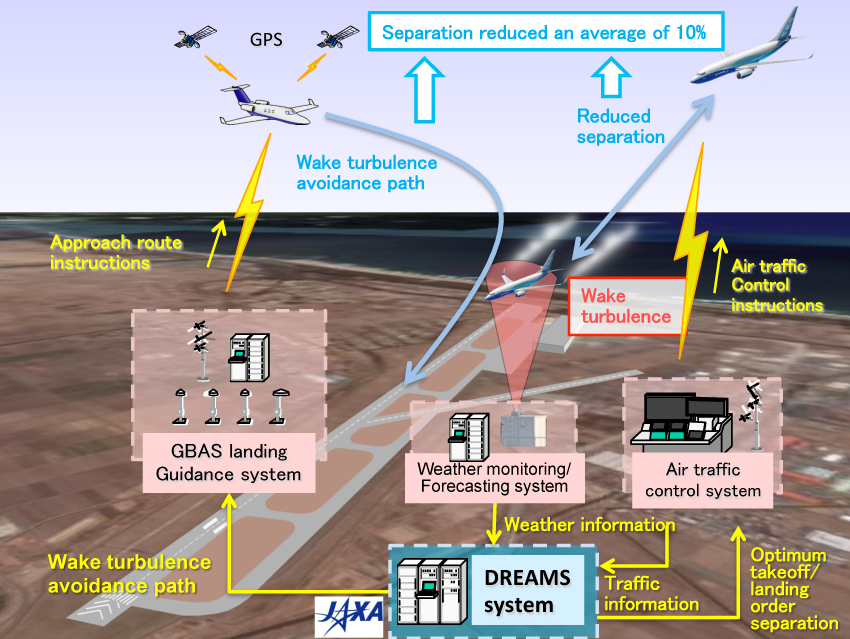
Conceptual view of system operation to reduce aircraft separation with wake turbulence prediction
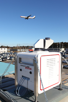 Measuring wake turbulence. The instrument in the foreground is a lidar
The power of the vortex generated by wake turbulence is determined by the weight of the aircraft. Today, in the case of large aircraft, an approximately two-minute interval is required between one takeoff or landing and the next, to make sure that wake turbulence has receded. In reality, though, it is not always necessary to wait for two minutes, and the way wake turbulence fades out depends on the weather conditions in the area. For instance, when there is no wind, a vortex remains in place until it fades out. But when there is a crosswind, the vortex is blown away, off to the side of the landing path, and then there is no need for the next aircraft to wait for two minutes to land.
We have developed a system that predicts the behavior of wake turbulence, which changes according to weather conditions, and automatically calculates safe separation for the following aircraft. As demand for flights is increasing every year, busy airports want to increase the number of takeoffs and landings. If it becomes possible to predict when wake turbulence will recede and to reduce the separation time between aircraft, airports will be able to handle more traffic.
To build a prediction model, we set up lidar (optical radar that can determine wind distribution) at Narita International Airport, and monitored wake turbulence generated by 3,320 takeoffs and landings. We observed the way the vortices of turbulence faded out or were blown away, and combined the results with weather data acquired at the same time. This allowed us to build a prediction model of how weather conditions change the behavior of wake turbulence.
Even though other countries have also studied wake turbulence, none of them have obtained such a large quantity of data with accuracy high enough to be used for prediction.
— With your wake turbulence prediction model, how much can you expect to reduce separation between aircraft?
By simulating some busy airports in Japan, we have confirmed that the current standard can be reduced by 12.7% on average. However, this is based on the premise that our model is combined with another method, called wake turbulence re-categorization (RECAT). Currently, the interval for takeoffs and landings is calculated based on the weight of the aircraft. The intervals are divided into three groups, but RECAT suggests sorting them more precisely, into six categories.
The International Civil Aviation Organization (ICAO) is now reviewing wake turbulence separation, and is looking at adopting RECAT as the standard. Combining RECAT with DREAMS technology, which can reduce separation between two aircraft in response to changing weather conditions, is expected to produce significant improvements.
We think reduced separation will be a solution to the delays that happen during peak hours at airports. For example, at Tokyo International Airport, commonly known as Haneda Airport, flights are concentrated in the morning and late afternoon, exceeding normal airport capacity by about 10%. If we can reduce separation by 10%, we think it will be possible to prevent such delays.
Predicting air flow change allows safer landings
— What technology have you developed for low-level turbulence?
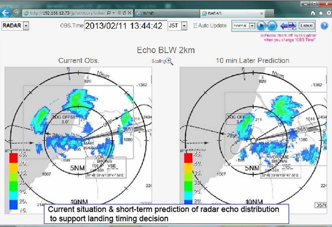
Radar Echo Display
The reason for most go-arounds at landing is wind, but in reality pilots are not informed of the status of wind in the sky just before landing. Anemometers at airports measure winds just above the runway, but not winds at an altitude of around 150 meters, which is about a minute before landing. To make landings safer, pilots do want real-time wind information, especially for that last minute of flight. So, by using weather observation sensors to predict the impact of low-level turbulence on aircraft, we have developed the LOw-level Turbulence Advisory System (LOTAS), which can alert pilots about risks in advance. LOTAS provides pilots in the air and flight dispatchers at the airport with real-time information about turbulence in the landing approach path, along with prediction data for the following 10 minutes. Pilots can receive the information via the Automatic Communications Addressing and Reporting System (ACARS), a communication system mounted on most passenger aircraft, so there is no need for air traffic controllers to convey the information verbally. Without increasing workload for air traffic controllers, LOTAS can support pilots in judging the optimal timing for approach to the runway.
— Why is prediction data provided for the upcoming 10 minutes?
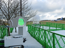 Weather observation sensors for LOTAS installed at Shonai Airport in Yamagata (lidar in the foreground and radar in the background)
This is not really the case at busy airports handling a lot of flights, but smaller local airports have relatively few flights, so when there is wind over the landing approach path, aircraft circle in the sky and wait. And the duration from waiting to landing is usually about 10 minutes. Seeing a prediction of wind turbulence for the next 10 minutes will allow pilots to make an informed decision on the timing of landing. Verification for LOTAS was conducted at Shonai Airport in Yamagata prefecture, in cooperation with All Nippon Airways (ANA), and more than 90% of the participating pilots agreed that the information was helpful.
But actually, the prediction period is also constrained by the size of the observation instrument. A large sensor can cover a wider scope, and if we had used one, we could have made predictions for even a 20-minute period, but we decided to go with a small observation instrument. Airports that are prone to being influenced by winds are often located in rural areas, such as remote islands, and these are municipally operated. We intentionally chose a small observation instrument because it is less expensive and easier to procure.
Spinoffs from supporting safe aircraft landing
— What are the challenges for practical application of LOTAS?
The challenge is to collect enough evidence of the system's effectiveness. I think we should present the effects quantitatively ⋅ for instance, by calculating the optimal timing for approach, how many go-arounds have been eliminated, and how much fuel has been saved as a result. So, first we would like to build a track record using the existing observation instruments.
We are co-developing a new turbulence information system, Airport Low-level Wind InformatioN (ALWIN), with the Japan Meteorological Agency (JMA). The LOTAS technology will be spun off to JMA, and ALWIN will use Doppler lidar and Doppler radar already installed at some airports, such as Narita International Airport. This lidar is installed to detect microbursts, which are drastic changes in wind, and ALWIN uses the lidar, originally introduced to prevent accidents, to support daily flight operation. We're currently preparing for ALWIN's public launch in April 2016.
— Finally, could you tell us about your plans for the future?

For wake turbulence, we are still at the stage of basic technology development, and there are still issues to address, including cooperation with air traffic controllers. The objective of the DREAMS project ⋅ to reduce separation by 10% ⋅ has been achieved. However, this shouldn't be the end. I am hoping to be able to continue research with organizations that specialize in air traffic control, such as the Electronic Navigation Research Institute (ENRI). On the other hand, the technology for low-level turbulence is now ready for practical application, so it has given me a great sense of accomplishment. I would like to ensure the smooth spinoff of the technology to JMA, and to provide full support. And I hope that it will eventually lead to the introduction of LOTAS to smaller local airports.
Naoki Matayoshi

Leader of the Weather Information Technology Section, DREAMS Project Team, Aeronautical Technology Directorate, JAXA
Mr. Matayoshi received his master's degree in 1997 at the Department of Aeronautics of the School of Engineering at the University of Tokyo. The same year, he joined the National Aerospace Laboratory of Japan (now JAXA), and has since been dedicated to research on aircraft flight dynamics and air traffic management. In 2008, he was a research fellow at the University of Liverpool.
[ April 1, 2015 ]