Combining navigational instruments to improve airport service availability
— Please tell us about high-accuracy satellite navigation technology.
Precision approach using satellite navigation with GBAS and ionospheric threats
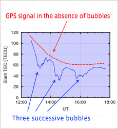 GPS signal affected by plasma bubbles
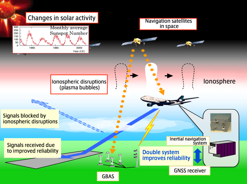
This technology is intended to support satellite navigation used for aircraft landings. There has been a recent trend toward using the on-board GPS devices of airplanes to guide them along the landing path, but radio waves from satellites are adversely affected by solar activity. At altitudes between 60 and 800 km, there is an electrically charged layer of the atmosphere known as the ionosphere. Radio waves from GPS satellites pass through it before reaching GPS receivers. A significant amount of solar activity disturbs this ionosphere, and causes magnetic storms and plasma bubbles (in which the electron density is much lower than in surrounding areas). This disrupts GPS signals, causing errors and sometimes lost signals.
Aircraft are also equipped with inertial navigation systems (INS), which calculate positional information from gyroscopes and accelerometers, but these do not have enough capability to be used for landings. The DREAMS project has created a highly reliable system that combines the advantages of GPS receivers and INS. With this system, GPS signals are received reliably even when a plasma bubble causes scintillation (a phenomenon in which the amplitude and phase of radio waves change). This system provides a highly reliable means of navigation for landings. In times when GPS signals cannot be received at all because of strong disruptions in the ionosphere, INS takes over to guide the plane to the approach path by providing backup navigational data. We expect this system to help eliminate landing reattempts and cancellations due to ionospheric disruptions. This will increase the safety and punctuality of air travel, and allow airports to receive more flights per day.
— So, GPS was not previously used for landings?
Currently, guidance toward the runway during landing is provided by the Instrument Landing System (ILS), which sends signals from the airport to the aircraft. However, ILS can be affected by the buildings and terrain around the airport, and so the industry is moving toward Ground Based Augmentation Systems (GBAS). GBAS receives GPS data, re-formats it, calculates a safe approach and landing path, and sends this information to approaching aircraft. Several airports in Germany, the United States, Australia and other countries have already started using GBAS, and eventually satellite-assisted landings should become standard. To use this system, aircraft must be equipped with a GBAS receiver. As this device is now standard on new aircraft, more and more airports can begin using the system as soon as they add this equipment to their ground stations.
Providing safe navigation during ionospheric disruptions
— How did you test this system?
 Staff boarding Hisho in order to take measurements during observation testing
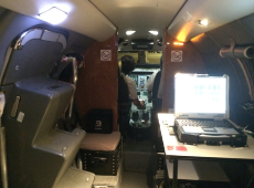 Pilots preparing for takeoff. DREAMS research PC on the right.
In 2012 and 2013, we performed experiments at New Ishigaki Airport using JAXA's jet flying test bed “Hisho". There was a significant amount of solar activity in those years, so we decided to conduct our experiments on the southern island of Ishigaki, as areas near the magnetic equator are more susceptible to the effects of ionospheric disruptions. We decided to conduct experiments in spring and autumn, when plasma bubbles are more likely to occur, and we actually managed to perform 17 successful flight tests that encountered interference from plasma bubbles near Ishigaki Island.
Satellite-based navigation services normally use information from around 10 GPS satellites. (The actual number differs slightly depending on the time of day.) When there are ionospheric disruptions such as plasma bubbles, information from several of these satellites is no longer obtainable, which results in a loss of guidance accuracy and prevents aircraft from landing. During our experiments on Ishigaki Island, the system was still able to perform successfully despite losing information from up to five satellites at one time. We were also able to continue receiving a signal in environments with strong scintillation. These experiments demonstrated system reliability ⋅ the ability to provide GBAS guidance and ensure the safe landing of aircraft even during disruptions in the ionosphere.
— Are similar experiments being performed in other countries as well?
Organizations in other countries are developing systems similar to the DREAMS project, but I think we are the first to test the system in environments of ionospheric disruption. Plasma bubbles and related phenomena normally occur only in areas near the magnetic equator, such as South-East Asia and India, and rarely in Europe or North America. In that sense, the data obtained in our experiments has significant value.
— What particular challenges did you face during development?
The flight tests were very challenging. Ionospheric disruptions are natural phenomena, and plasma bubbles occur largely at night, so we conducted the experiments between 8:00 p.m. and 12:00 a.m. Whenever we had a test flight without an occurrence of plasma bubbles, we were very disappointed. We were still able to obtain data on normal conditions, so it was not a total loss, but to get statistically significant data, we needed to encounter as many ionospheric disruptions as possible. There were certainly difficult times, but with the help and cooperation of everyone involved, including those at the Japan Civil Aviation Bureau and New Ishigaki Airport, we were able to achieve satisfactory results.
Expanding the reach of DREAMS project technology
— Please tell us about your future developments.

I believe there is potential to further expand on this integration of INS with GPS technology. For example, it could be used to help aircraft navigate from the runway to the terminal, which is currently done manually. Using GPS signals around airports is problematic: the many kinds of radio waves that abound in airports can sometimes interfere with GPS signals, and also buildings can reflect the signals, creating significant errors. Because of this, it is difficult to provide navigation based solely on GPS. But with the system we have developed, getting an airplane from the runway to the terminal could be entirely automated. Also, this system is not necessarily limited to aircraft, and could be used in the operation of driverless vehicles. The experiments we performed used only the American GPS system, but there are other similar positioning systems, such as Europe's Galileo and Russia's GLONASS. Going forward, I plan to investigate how we can make our technology compatible with these other satellite systems, so that it can be used all over the world in many different applications.
Toshiaki Tsujii, Ph.D.

Leader of the Satellite Navigation Technology Section, Sub-Manager of the DREAMS Project Team, Aeronautical Technology Directorate, JAXA
Dr. Tsuji obtained his doctorate in applied mathematics and physics from Kyoto University. Subsequently, he joined the National Aerospace Laboratory of Japan (now JAXA). He has participated in demonstration projects of reusable space transportation systems, and the DREAMS project. His area of expertise is high-accuracy satellite navigational technology, robust GNSS receiver technology, and ionosphere observation technology. From 2000 to 2002, he was a visiting fellow at New South Wales University in Australia. Currently, he teaches a course on aeronautical navigation at the System Design Department of Tokyo Metropolitan University.
[ April 1, 2015 ]