Real Images from Space for Children
— Could you tell us about the Young Astronauts Club - Japan?
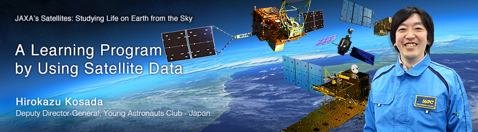
 A Young Astronauts Club – Japan event (water rocket)
The Young Astronauts Club was established in 1986. By offering children hands-on learning programs about space and science, we aim to cultivate their curiosity, spirit of adventure, and craftsmanship, in order to promote the development of human ability that will contribute to our society. We have about 140 chapters nationwide. Each branch has about 30 children and some instructors, and holds monthly events, which include making and flying water rockets, practicing astronomical observation, and conducting scientific experiments. About 70 percent of the members are elementary-school age, but adults can join, too.
— Tell us about your contest that uses satellite data?
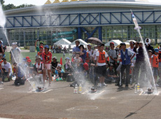
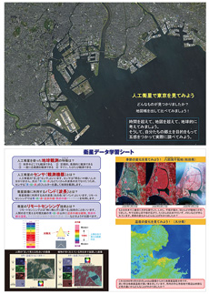
 From a report by an elementary school student, using satellite images from DAICHI and Landsat
Every year, with the help of schoolteachers and experts who have been interacting with children through YAC activities, we have a contest for the general public on utilizing satellite data. We started this contest in 2011, so this year will be our fourth. The contest asks participants to analyze raw satellite images and write a report about their findings. The data they are provided will be from JAXA’s Advanced Land Observing Satellite (ALOS) DAICHI and the images have already been processed and appear in color. Unprocessed images are different: they have a certain bandwidth (observation wavelength range), and appear black and white. When they are processed for the analysis by the software which is designed for use by children, the images come up in color. Children decide what to look for in the data, and choose the method of analysis. The purpose of this contest is to expose children to real images from space, and to encourage them to make new discoveries for themselves.
— Can children really analyze images on their own?
Yes, they can. On our website, we explain in simple terms how to use the software, and all they have to do is to follow the instructions. Before we launched the contest, many experts we talked to said it would be too difficult for elementary-school children to analyze satellite data. But the old saying “practice makes perfect” turned out to be true. When we taught kids how to use the software, they had no trouble understanding, and started working with it within 30 minutes. Children are definitely faster learners than adults.
The spark that ignites children’s hearts
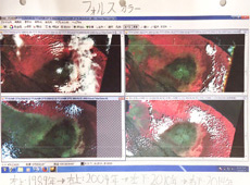
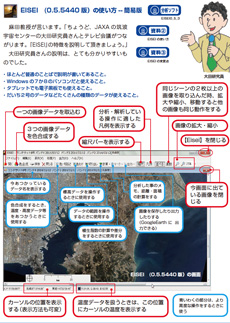
 Event where children can analyze satellite images
— How did the kids react?
Watching children trying to analyze satellite data, I have noticed that they always cheer at the moment when the images turn from black-and-white to color. I would say that this is the moment when their hearts are ignited. I was very pleased when I heard a child say, “It was so much fun to analyze the satellite data myself, and to understand the attraction of satellites, which I didn’t really know before. I want to tell my friends about it, too.” There were also kids who said, “In the future, I want to become a space scientist,” and “I used to have a vague idea that I wanted a space-related job someday, but now I am certain.”
— What do children tend to look for with satellite data?
Many children study global environmental problems, such as deforestation and desertification. Also, since Japan is very much a volcanic country, many children work on volcanoes. Where lava has flown after an eruption, there are no trees to be seen. But eventually, a few years later, plants start to grow again, and the children observe the way the land recovers. Also, since Landsat can monitor changes in temperature, some children use its data to study places with high temperatures.
Satellite data is a great teaching tool
— How did you get the idea to use satellite data for your learning programs?
It was started in 2009, when we responded to a call from the Ministry of Education, Culture, Sports, Science and Technology for a human ability development program using satellite data. Fortunately we were selected, and that led to the first contest. Having said that, prior to the call for proposals, we were always interested in using satellite data for our hands-on learning programs. YAC’s motto is to give children real experience by exposing them to real things. For example, we have taken children to the Tanegashima Space Center to observe a rocket launch, and have had JAXA astronauts and space experts come in as guest speakers. But only a limited number of children can participate each time, and going to Tanegashima is expensive. And then we thought of satellite data. Kids can use the very same data that JAXA researchers are using, and there’s also the added advantage that they can do the work at home.
— What is the advantage of satellite data as educational material?
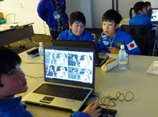
 Educational material using images acquired by JAXA’s Earth observation satellite
First of all, you can cultivate “roots of thinking.” Our website offers not only instruction for the image-analysis software, but also materials that teach the principles of designing and operating spacecraft, etc. For instance, it is difficult to synthesize images, which have a specific wavelength range, unless you understand RGB (red-green-blue) principles. Also, without knowing how reflection works, you won’t understand that a satellite sensor pointed at Earth receives reflection of sunlight by plants. So, we teach children such basic principles before they work on image analysis. We call it developing the “roots of thinking.”
Satellite data can also help cultivate the “wings of thinking.” We learn from textbooks that Earth observation satellites can monitor illegal logging and desertification. But when they work with satellite data themselves, kids are free to think of other potential uses for the data. They can come up with their own questions and their own ideas about possible uses for satellites – things that are not mentioned in textbooks. We call such ability to think independently the “wings of thinking.” If we can help children develop such wings, they may think of a solution that uses satellite data when they grow up and encounter some kind of challenge. We also hope that the experience of participating in our contest will help kids become adults who want to do something good for society.
— It sounds like satellite data can be very valuable as educational material.
By using satellite data, children learn to study and research whatever has caught their attention, and also to think about environmental problems on a global scale, beyond national borders. So yes, we regard satellite data as very good educational material. People tend to think that satellite data is used in the hard sciences only, but it actually can be used for geography and social studies as well. And writing reports is also good practice for Japanese kids. So, in my opinion, satellite data can be useful in many different ways. By providing more information to schoolteachers, we would like to promote the use of satellite data in class.
Getting more children interested in satellites
— What is the greatest challenge in using satellite data?
 Instructions for the satellite image analysis software can seem challenging.
Our image-analysis software was developed for children, so once people start using it, they generally find it easy. The problem may happen earlier: when downloading and installing the software, people tend to feel it is troublesome or difficult, and sometimes they give up during the first step. Children usually feel more comfortable if there is an instructor to show them how to use the software; that seems to work better than just making them read the instructions and try on their own. We would like to train more instructors, so we can have more opportunities to teach children directly.
— Would you like to continue holding this contest?
Yes, I would. Along with the contest, we are planning to start more hands-on satellite programs for children, such as an event where they can add their own images to satellite images from DAICHI-2. According to questionnaires collected at our events, the most popular subject was typically astronauts, followed by rockets, with a few children interested in satellites. However, with the success of the asteroid explorer HAYABUSA, satellites are increasingly gaining attention. If we can teach children about the function of satellites in more depth, I think more of them will develop their interest for a long period of time.
— What would you like to see from JAXA?
We buy DAICHI images from PASCO CORPORATION and the Remote Sensing Technology Center of Japan (RESTEC), but we hope that one day all the data will become available at no cost. Processed satellite images can be used for free for educational purposes (for example on a website), but what we want are the raw data, which we have to pay for. And if we provide the raw data to children, that’s considered redistribution by JAXA, which, under the current terms of use, actually costs extra. Our budget allows us to purchase only a few dozen DAICHI images, so we are using images from the U.S. Landsat satellites, too. Although Landsat’s pictures have lower resolution than DAICHI images, they are very handy because we can obtain data from around the world easily and at no cost. DAICHI-2 observation data became available last November, but it’s different from DAICHI data, becauseDAICHI-2 uses only radar. So we have to look for alternatives. If JAXA can revise its policies on the use of its satellite data for educational purposes, it will be easier for us to continue using it in our contest, and there will be more opportunities for children to study and interact with real Japanese satellite images.
- Photos courtesy:
- Young Astronauts Club - Japan
Hirokazu Kosada
Deputy Director-General, Young Astronauts Club – Japan
Mr. Kosada graduated from the School of Project Design at Miyagi University in 2003, and was assigned to the department of education promotion and member services of the Young Astronauts Club – Japan. His work has included assisting in setting up branches across the nation, creating educational materials for young people, and planning and operating space-education programs. From 2010 to 2013, he worked on social education at the JAXA Space Education Center. He was appointed to his current position in 2014.
[ Mar. 13, 2015 ]
- Using Satellites to Prevent Accidents on Earth
- Satellites Watch Over the Northern Sea Route
- A Digital 3D Map to Support Life Around the World
- A Learning Program by Using Satellite Data
- Using Satellites to Make Art on Earth