Years of research produce the world’s most precise 3D map
— Could you tell us about the Global Digital 3D Map Distribution Service, for which you are the project leader?
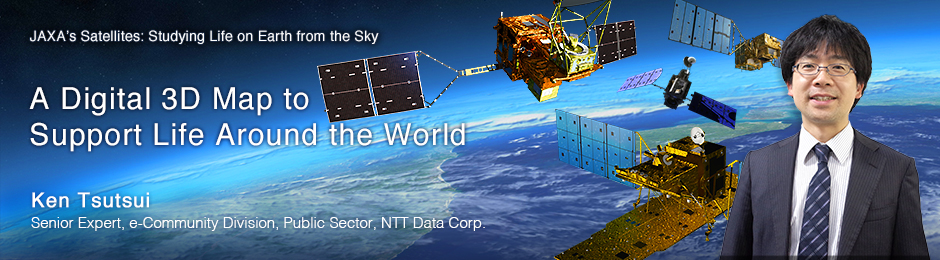
A digital 3D map of Mt. Everest

DEM of Mt. Everest
The Global Digital 3D Map Distribution Service provides highly precise digital 3D maps made using approximately 3 million satellite images taken by the Advanced Land Observing Satellite (ALOS) DAICHI. We offer Digital Elevation Models (DEM), which indicate height, and orthorectified images, which indicate horizontal location. We provide two types of DEM: Digital Surface Models (DSM) and Digital Terrain Models (DTM). An orthorectified image is an image taken from above, from which distortion is removed before it is calibrated to be overlaid on a map. For example, when a high mountain is imaged from above, it looks tilted due to characteristics of the sensor lens. In an orthorectified image, this distortion is corrected.
— How does the resolution of these maps compare with other 3D maps?
Our global digital 3D maps are the most precise in the world: they represent topography with 5-meter resolution and a height accuracy of 5 meters. The other existing global 3D maps are SRTM, with 90-meter resolution, which uses data acquired by the space shuttle, and ASTER GDEM with 30-meter resolution, which was developed jointly by the Ministry of Economy, Trade and Industry, Japan, and NASA. Compared to these two maps, it’s clear how much of an improvement our maps represent. In addition, we offer a very competitive price, staring from 200 yen per square kilometer, which is approximately a quarter of the current market price. Distribution started in February 2014 with the areas already mapped, and we are aiming to complete the global 3D map by March 2016. It will be the world’s most precise digital 3D map covering the entire planet.
— So it’s going to take two years in total to complete?
Three million satellite images are indeed a tremendous volume. A data set consists of 2 or 3 images, and we are currently processing about 2,000 to 3,000 sets a day. In 2006, when DAICHI was launched, it took a whole day to process one data set, so the speed of data processing has greatly improved. Creating this map is only possible thanks to advancements in the image processing algorithm and in IT automation in general.
What I mean is that the technology that allows us to create a digital 3D map using satellite images is the fruit of many years of research. As a matter of fact, the image processing algorithm used for calibrating and processing the data is based on 10 years of research at JAXA and RESTEC [the Remote Sensing Technology Center of Japan]. NTT DATA started developing technology to commercialize the algorithm in 2009, in collaboration with RESTEC. Our digital 3D maps are a result of all these efforts. Our distribution service would not have been possible without this kind of long-term research.
“Japan Quality”
— Is there anything you focus on in particular, in terms of offering the service?
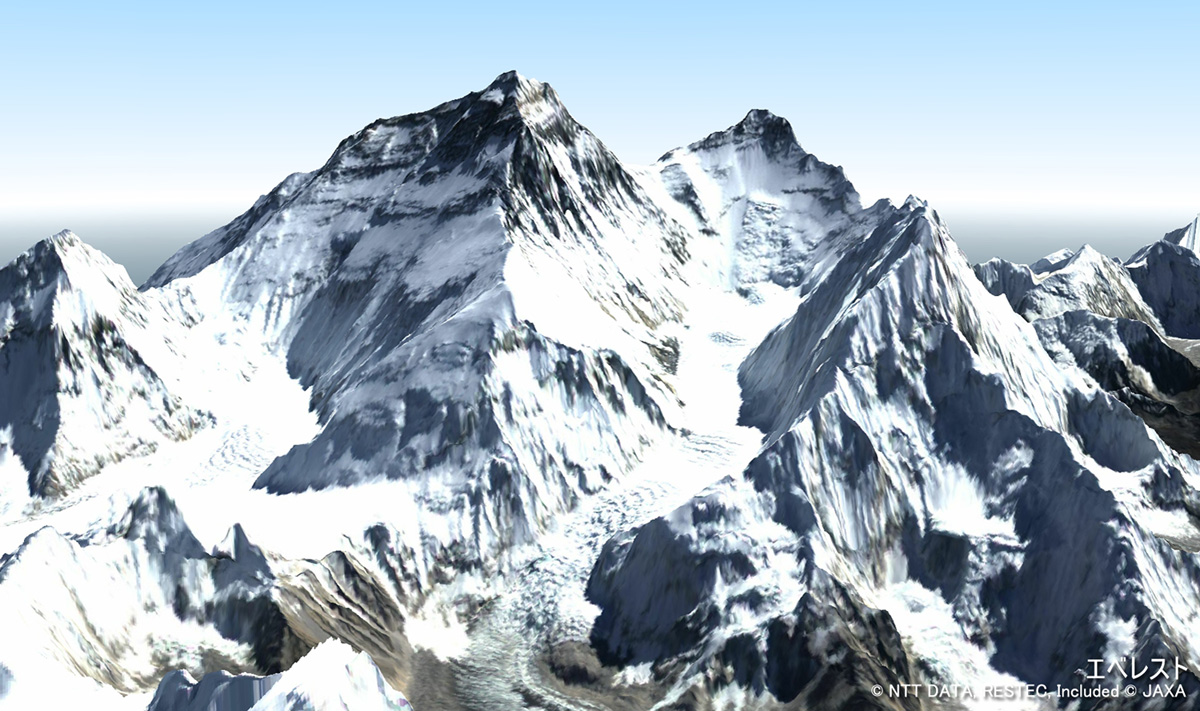
Digital 3D map of the Grand Canyon
We are conscious about offering a high-quality service that is unique to Japan – “Japan Quality.” We put special emphasis on high-precision positioning, to differentiate our service from the ones provided by Europe and the United States. For instance, even for places that are topographically difficult to analyze, such as a small, isolated stretch of land, or a desert, high quality is guaranteed. We also offer high-quality dedicated user support, with flexibility to meet each customer’s needs. For example, a key to predicting flood damage is having information about the height of the ground. Height can be difficult to determine when there are buildings in the image, so when we process the data, we erase the buildings, to provide an accurate flood-prediction map for our clients. We have been getting very good feedback from users, so we would like to continue to provide such high-quality services.
— Without the DAICHI satellite, would this level of precision have been difficult to achieve?
Yes indeed. Such precision is possible thanks to DAICHI’s optical sensor, the Panchromatic Remote-sensing Instrument for Stereo Mapping (PRISM). The three million satellite images we are using are ones with few clouds, which were selected from all the images taken by PRISM. This sensor can take images of a single location from three different directions – nadir, forward and backward – almost at the same time, which allows us to obtain highly accurate topographic information. For example, if a high mountain is imaged from only two directions, there are inevitably areas that cannot be seen, but from three directions, almost all facets of the mountain can be covered. Of course, having a high-performance sensor is not the only requirement. You also need technology to analyze and process the data, so that you can make the best use of the sensor’s performance, and technology to control the satellite’s attitude and to determine the right position to take images from. Having all of these, it becomes possible to make the world’s most precise digital 3D map.
— How have your digital 3D maps been used?
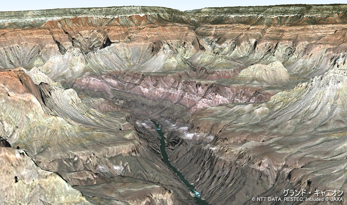
Digital 3D map used to predict damage caused by flooding and tsunami
They have been used for various purposes, such as developing maps in emerging nations, predicting damage from natural disasters, and surveying natural resources. For instance, our 3D map has been used to look for water resources in Africa based on topographic features, and has led to exploratory drilling. Also, because of its precise contour lines, it was used to study a location for building a new road, and the disaster management agency of the Philippines has used our map to update their volcanic hazard map and successfully mitigate damage. Also, the map has been used to study a location for building a wind farm. To achieve a more accurate simulation of wind, a DSM, which shows trees, buildings, and roads, is a better tool. When we started the distribution service, we expected higher demand in Asia, as it is closer to Japan, but it turned out that we also have many users in other regions of the world, such as Africa and South America. Our market is expanding globally.
From ‘to look at’ to ‘to utilize’
— What about the needs in Japan?
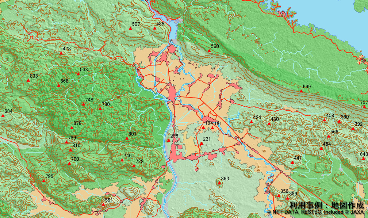
Digital 3D map used in conjunction with other geospatial map
Composite of a global digital 3D map and a DigitalGlobe satellite image (courtesy: NTT Data Corp., RESTEC, DigitalGlobe, JAXA)
In Japan, the Geospatial Information Authority of Japan (GSI) has already been providing detailed data, so we weren’t initially expecting much demand here. However, to our surprise, we’ve been receiving many inquiries from within Japan from the start. Although our 3D maps have the same scale as GSI maps, at 1:25,000, our users seem to appreciate the features they cannot get from GSI only. For instance, by combining our data and GSI data, you can extract information about the height of trees and buildings. Thus, by combining with other geospatial data, our map can be used flexibly to match your needs. In Japan, our 3D maps have also been used for disaster-management research and video production.
— By combining with different data, you can add more value?
Exactly. We would like to further expand the potential of our 3D maps by offering additional value in our service. For example, Japan’s disaster-management technology, such as hazard maps, is outstanding. If we can work with an organization that has such technology, we will be able to add more value to our service. In addition to our global digital 3D maps, we also provide satellite images from a U.S. company called DigitalGlobe, which have the world’s highest resolution – 30 centimeters. Great synergy can be achieved when these two are combined. When a DigitalGlobe image, which shows great detail, is added to basic geospatial data obtained with DAICHI’s highly accurate height measurements, the map’s precision can be further enhanced to a level good enough for urban planning, and for design and management of infrastructure, including railways, roadways, and electric grids. In a nutshell, we can transform the map into a “usable map.” We have a motto in providing our service, “A 3D Map that goes from ‘to look at’ to ‘to utilize’”.
— Can your service be used by anyone?
Yes. But we have a self-policing system to prevent misuse of our 3D maps. We check who will be using a map and for what purpose. We will stop providing the service without fail if it is not for a peaceful purpose. Our goal is to help make the world a safer, more prosperous and more comfortable place to live. Contributing to society by making people’s lives more convenient – we believe that this will lead to profit in a true sense.
— What is the main challenge in providing digital 3D maps?
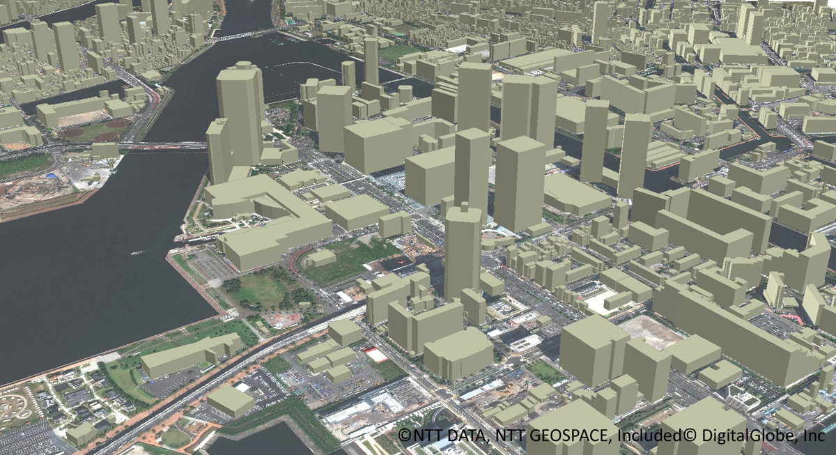
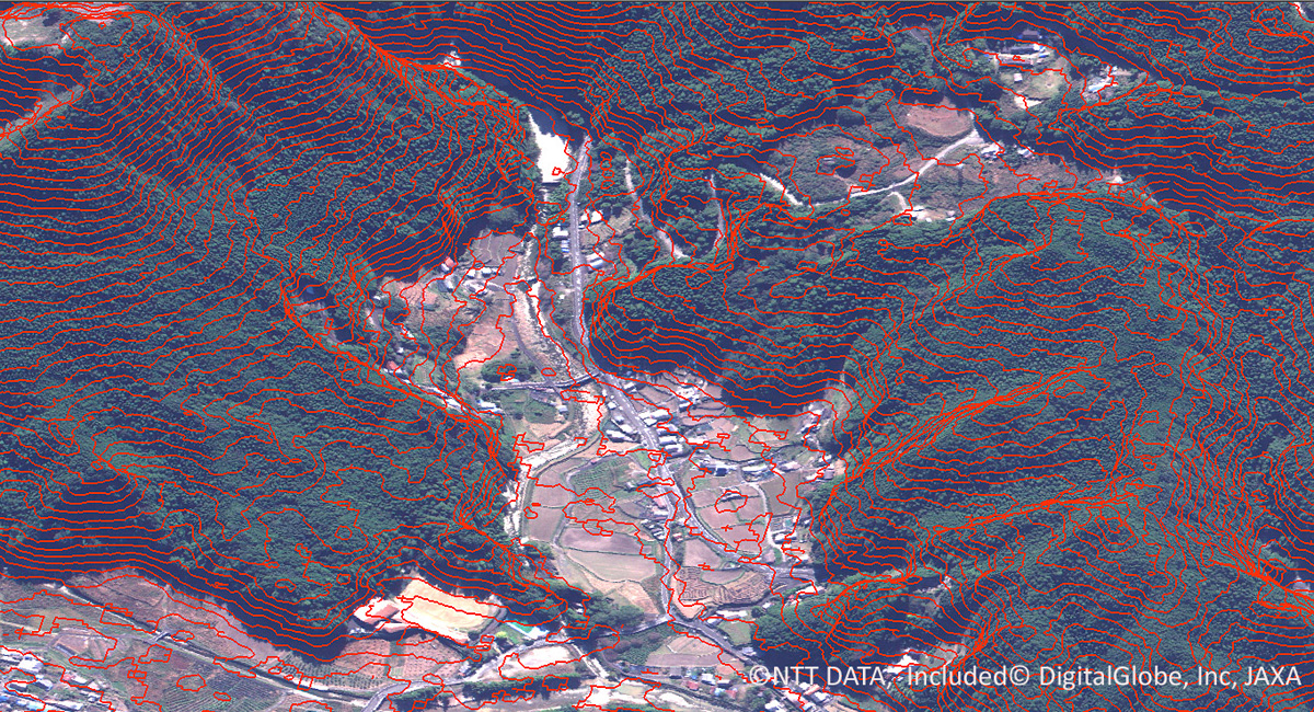
3D urban map, with precision enhanced by a DigitalGlobe satellite image (courtesy: NTT Data Corp., RESTEC, DigitalGlobe, JAXA)
The DAICHI data, which we have been using, was mostly obtained around 2010. I think that it is new enough as basic geospatial data, but the world is changing rapidly. For example, cities in emerging nations and the status of natural-resource development can change drastically in six months or a year. Ideally we would always have updated 3D images, so how to keep up with such changes is a challenge. Europe and the U.S. are leading the world in the application of satellite images, but we aim to become the world’s top distribution service for global digital 3D maps. We hope that we can create an era where Japanese technology will help sustain safety in people’s lives around the world. And a key to this is to understand the needs of users and to speedily bring our services to market.
Although we greatly regret that DAICHI ceased operation in 2011, DAICHI-2 was launched in May 2014, and the distribution of its observation data started in November. In addition, an advanced optical satellite with further improved performance is currently under consideration. Although the sensors onboard DAICHI and DAICHI-2 are different, we are sure that the experience and knowledge gained through building our distribution service will prove valuable. It is also one of our tasks to pass along our experience to JAXA to aid in the development of new satellites in the future.
Further advancements in 3D mapping technology
— What are your hopes for the future?
I studied resources and environmental engineering at university, and since joining NTT DATA Corp. I have spent more than 10 years studying 3D mapping while working on satellite imagery. I went to graduate school after I started working at NTT DATA. I developed an analysis method for 3D maps, and used it to research landslide disaster management. As part of the research, I learned how to make 3D maps and how they could be used – what kind of satellite images and what kind of analysis and processing methods are required, and how they need to be processed to be of practical use. So from that point of view, I have end-to-end knowledge of the provision of 3D maps. I would like to put this knowledge to good use, and continue developing technology and services that will lead to further applications and utilization of 3D maps.
Everyone involved in this project, including JAXA and RESTEC staff, is very enthusiastic, and the skill level of the researchers and engineers is very high. I would like to emphasize this strongly, because they usually don’t get the credit they deserve, as data analysis and processing is low-key work that requires quiet, persistent effort. Furthermore, their achievements will not be recognized unless the service is used. So it is our mission to promote the use of 3D maps in many different fields and places – in other words, to expand the potential of the use of satellite images. At the moment, our main clients are private companies and government-affiliated organizations, but we would like to promote our service in places more familiar to everyone, such local municipalities and the education sector. In a way, this may seem more like public service, but that’s the area we would like to expand to.
— What are your expectations for JAXA?
As I explained earlier, the technology for making a digital 3D map using satellite images is the fruit of 10 years of research and development. The technology has advanced thanks to this dedicated research, and has allowed us to make the world’s most precise digital 3D map. This was only possible thanks to the DAICHI satellite, and now Japan’s digital 3D map technology is getting attention from around the world. I am very much looking forward to JAXA’s future satellites, and many more years of new research building on current successes.
- Photos courtesy:
- NTT Data Corp., RESTEC, JAXA, except as indicated
- Related link:
- World 3D Topographic Data
Ken Tsutsui, Ph.D.

Senior Expert, e-Community Division, Public Sector, NTT DATA Corporation
Dr. Tsutsui obtained his master’s degree in 2000 from the Faculty of Science and Engineering at Waseda University, and joined NTT DATA Corp., where he was assigned to R&D for application technology and product development using French and U.S. commercial satellite images. In 2006, he obtained his doctorate from the School of Engineering at the University of Tokyo. Starting in 2007, he worked on application technology for satellite images acquired by JAXA’s Advanced Land Observing Satellite (ALOS) DAICHI, as well as the development of a distribution service for the images. He is currently responsible for the development of geospatial information services using satellite images, such as the Global Digital 3D Map Distribution Service.
[ Mar. 13, 2015 ]
- Using Satellites to Prevent Accidents on Earth
- Satellites Watch Over the Northern Sea Route
- A Digital 3D Map to Support Life Around the World
- A Learning Program by Using Satellite Data
- Using Satellites to Make Art on Earth