
Q. Could you tell us about the role of the Cabinet Office in disaster reduction in the Government of Japan?
One of our government's primary concerns is to protect citizens from natural disasters such as earthquakes and typhoons. The Cabinet Office coordinates governmental policies and programs toward disaster prevention/mitigation, preparedness, response, and recovery & reconstruction. As soon as a disaster occurs, a special office for disaster information management is immediately formed in the Cabinet Office. This office collects information and ensures that countermeasures are taken promptly. On a day-to-day basis, we perform various disaster-management functions. These include setting the primary agenda at the Central Disaster Management Council, supporting the ministries with upgrading & maintenance of their disaster-prevention facilities and with disaster-prevention training, and running public-awareness campaigns. We also promote international cooperation for disaster reduction.
Q. What is your role in the Cabinet Office?
Damage caused by the landslide in Leyte, Philippines

I'm in charge of promotion of various campaigns for disaster reduction, including public relations and international cooperation. Disaster prevention is about mitigating damage through preparation. We run campaigns to inform the public what can be done at home and at work, offering tips such as attaching furniture to the wall in preparation for earthquakes. The Ministry of Land, Infrastructure and Transport (MLIT) and local governments have recently produced “hazard maps.” These disaster-prevention maps indicate the estimated scope of damage for foreseeable natural-disaster scenarios. Part of my job involves promoting the production and dissemination of such maps nationwide.
As part of our international cooperation efforts, I promote the sharing Japan's knowledge and technologies with other countries that are frequently hit by natural disasters. Among developed nations, Japan has the richest experience of natural disasters, including earthquakes, volcanoes, tsunamis, flooding and typhoons. Despite all this, however, we Japanese don't live in constant fear, because our country has taken disaster management very seriously. In the 1940s and '50s, thousands of Japanese lost their lives every time a typhoon hit the country. Today, typhoons are no less powerful but far less deadly. This is because the nation has taken precautions - for example, advanced meteorological forecasting, building embankments and dams, and facilitating the planting of forests. I would like to see Japan's experience and know-how to contribute to global disaster reduction.
Q. How do you expect satellites to assist with disaster management?
If we cannot assess a disaster because ground transportation routes are blocked, I would like to see satellites function as a bird's eye to gather information quickly and precisely. Since Typhoon Vera hit Japan in 1959, the government has established post-disaster management protocols. First of all, local fire departments and police forces, as well as the local office of the Ministry of Land, Infrastructure and Transport, investigate casualties and assess the damage to housing and roads. Then all information is quickly amalgamated and submitted to the government. This system only works, however, when ground transportation routes are open. When roads are blocked, helicopters are an option, but they cannot fly at night, and they are also affected by weather conditions. In such situations, a satellite is potentially the best means for prompt damage assessment.
As a graduate student, I was already hearing about possible contributions of remote-sensing technology to disaster management. And thanks to the success of the Advanced Land Observing Satellite Daichi (ALOS), the technology has finally become practical. I've seen Daichi's three-dimensional data of the landslide in Leyte, Philippines in February 2006. The data clearly showed the spot where the landslide took place, and where a large quantity of soil had moved. If we can get 3D topographic maps, we can easily create flood forecast charts, for example, that will clarify which areas are safe from flooding due to their elevation and which areas are not. Although there are still many countries without proper survey maps, an earth observation satellite will be able to provide them with hazard maps. This is one benefit of satellite applications. Also, on many island countries in Asia, it is often difficult to reach the small islands in case of disasters. If a disaster disrupts their communication systems, such islands can be completely isolated. In such circumstances, satellites would be the best means of assessing damage. I really hope that satellite images will be used in disaster management not only in Japan but also in many other countries.
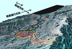
Topographic effect of the Solomon Islands earthquake
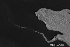
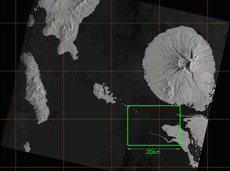
Pre-disaster Image
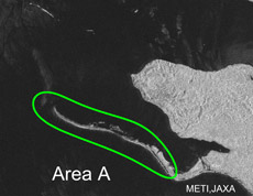
Post-disaster Image
Area A has stretched compared to pre-disaster

One of our government's primary concerns is to protect citizens from natural disasters such as earthquakes and typhoons. The Cabinet Office coordinates governmental policies and programs toward disaster prevention/mitigation, preparedness, response, and recovery & reconstruction. As soon as a disaster occurs, a special office for disaster information management is immediately formed in the Cabinet Office. This office collects information and ensures that countermeasures are taken promptly. On a day-to-day basis, we perform various disaster-management functions. These include setting the primary agenda at the Central Disaster Management Council, supporting the ministries with upgrading & maintenance of their disaster-prevention facilities and with disaster-prevention training, and running public-awareness campaigns. We also promote international cooperation for disaster reduction.
Q. What is your role in the Cabinet Office?
Damage caused by the landslide in Leyte, Philippines
As part of our international cooperation efforts, I promote the sharing Japan's knowledge and technologies with other countries that are frequently hit by natural disasters. Among developed nations, Japan has the richest experience of natural disasters, including earthquakes, volcanoes, tsunamis, flooding and typhoons. Despite all this, however, we Japanese don't live in constant fear, because our country has taken disaster management very seriously. In the 1940s and '50s, thousands of Japanese lost their lives every time a typhoon hit the country. Today, typhoons are no less powerful but far less deadly. This is because the nation has taken precautions - for example, advanced meteorological forecasting, building embankments and dams, and facilitating the planting of forests. I would like to see Japan's experience and know-how to contribute to global disaster reduction.
Q. How do you expect satellites to assist with disaster management?
If we cannot assess a disaster because ground transportation routes are blocked, I would like to see satellites function as a bird's eye to gather information quickly and precisely. Since Typhoon Vera hit Japan in 1959, the government has established post-disaster management protocols. First of all, local fire departments and police forces, as well as the local office of the Ministry of Land, Infrastructure and Transport, investigate casualties and assess the damage to housing and roads. Then all information is quickly amalgamated and submitted to the government. This system only works, however, when ground transportation routes are open. When roads are blocked, helicopters are an option, but they cannot fly at night, and they are also affected by weather conditions. In such situations, a satellite is potentially the best means for prompt damage assessment.
As a graduate student, I was already hearing about possible contributions of remote-sensing technology to disaster management. And thanks to the success of the Advanced Land Observing Satellite Daichi (ALOS), the technology has finally become practical. I've seen Daichi's three-dimensional data of the landslide in Leyte, Philippines in February 2006. The data clearly showed the spot where the landslide took place, and where a large quantity of soil had moved. If we can get 3D topographic maps, we can easily create flood forecast charts, for example, that will clarify which areas are safe from flooding due to their elevation and which areas are not. Although there are still many countries without proper survey maps, an earth observation satellite will be able to provide them with hazard maps. This is one benefit of satellite applications. Also, on many island countries in Asia, it is often difficult to reach the small islands in case of disasters. If a disaster disrupts their communication systems, such islands can be completely isolated. In such circumstances, satellites would be the best means of assessing damage. I really hope that satellite images will be used in disaster management not only in Japan but also in many other countries.
Topographic effect of the Solomon Islands earthquake
Pre-disaster Image
Post-disaster Image
Area A has stretched compared to pre-disaster
Q. What needs to be improved in disaster management with satellites?
It takes about two days for Daichi to come back to the same imaging point to perform emergency observation, which can be too late. I would like to see a satellite capable of imaging the same area not every other day but daily, or even every 12 hours. Modern weather forecasting uses images comprised of weather charts and meteorological satellite images. As a result, we have become very accustomed to metrological satellite images because we see them on TV everyday. With a weather chart and a satellite image together, you can really see the clouds the forecaster is talking about. Satellite images have increased the reliability of weather forecasting. Similarly, if topographic data comprised of Earth observation satellite images can be distributed daily, it will greatly stretch satellite applications. “Seeing” is very convincing. If viewers are routinely exposed to that kind of data everyday, they will eventually start making more use of it. I'd also like to see information collected by Earth observation satellites and meteorological satellites provided together as a set. In the case of a flood, as an example, I think if people can see rising water levels due to heavy rain, with both satellite images in real time, more people will make practical use of that kind of information.
Q. Do you have any recommendations for JAXA's future?
The most important thing is the speed of information delivery. Daichi currently prioritizes disaster observation, but I think that the speed of its data delivery needs to be improved. The Japanese people expect a very high level of disaster management. They feel it is too late to learn in a newsflash about an earthquake that happened an hour ago. When an earthquake took place in the Solomon Islands on April 2, 2007, it took several days before Daichi's observation data was released. If observation data become available within half a day at the latest, satellite applications will have greater potential.
Daichi is capable of producing 3D maps. If hazard maps for flooding and tsunamis were created for other Asian countries, even people in countries without precise elevation maps would be able to find out where to take shelter when a tsunami warning happens. I think this would be a great improvement.
We need reliable information to strengthen Japan against natural disasters, so that no one has to lose their life when an earthquake or a typhoon hits. But it is not enough to just distribute information. Good visual tools often help motivate people to take action - even people who have little interest in disaster prevention. I think that satellite images have the same impact. I hope the potential of satellite images will be maximized.
Satoru Nishikawa
Director for Disaster Preparedness, Public Relations and International Cooperation, Cabinet Office, Government of Japan
Mr. Nishikawa received a Master's degree in Urban Engineering from the University of Tokyo, and in 1982, joined the National Land Agency (currently the Ministry of Land, Infrastructure and Transport of Japan). From 1989 to 1992, he served in the Disaster Prevention Bureau, where he worked on the annual Governmental Report (White Paper) on Disaster Management, on disaster prevention for companies, and on the International Decade for Natural Disaster Reduction (IDNDR). After serving as the Senior Relief Coordination Office at the Department of Humanitarian Affairs (currently OCHA) of United Nations in Geneva, Mr. Nishikawa worked at the Tokyo metropolitan government, the National Land Agency, and the Ministry of Land, Infrastructure and Transport of Japan. He was Executive Director of the Asian Disaster Reduction Center from 2001 to 2004, and was appointed to his current position in July 2004. He belonged to the on-site disaster liaison office when the Niigata Chuetsu earthquake happened in 2004, and also contributed to the success of the United Nations World Conference on Disaster Reduction in January 2005. Mr. Nishikawa has also been involved in promoting the nationwide public campaign for disaster reduction, which was set up by the Central Disaster Management Council, and in the Business Continuity Planning.
Hideshi Kozawa Satoru Nishikawa Tatsuya Yamashiro / Munehiro Nagumo Orbita Roswintiarti History of JAXA's Earth Observations