


Q. Could you tell us about the work the National Police Agency does in disaster management?
Yamashiro : When a disaster occurs, the police immediately begin rescue and evacuation operations. We call police activity at the time of disaster, including rescue, disaster security. The duties of the police are protecting national safety and keeping public order. Disaster security is an important element of these duties. When a disaster occurs, all the police forces across the country, even those whose jurisdiction is outside the disaster area, work together.
Disaster management has to be a national scheme. The Police, the Fire Defense, and the Self-Defense Forces are units led by the Disaster Prevention Bureau of the Cabinet Office. Various related ministries, agencies and self-governing bodies also participate. The whole country is united in this task. The core of the police mission during a disaster is to take action - our task is to rescue any citizens in danger as fast as possible.
Q. Could you describe your assignments in disaster management?
Yamashiro : I belong to the Office of Natural Disaster and Rescue. When a disaster happens, our office functions as a coordinator of overall police activities. For example, after the Noto Peninsula earthquake on March 25, 2007, we immediately contacted the prefectural police in Ishikawa and other prefectures to dispatch police officers to help, and provided them with guidance on disaster security. We also gathered information about the damage, and reported to the Prime Minister's Office. Basically, during disaster management, the government needs to be proactive, and it is part of our job to provide the Prime Minister's Office with up-to-date information.
Nagumo : At the Communications Operation Office of the Info-Communications Bureau, we operate communication systems for the police. When disasters happen, information in the form of audio and video is transmitted from disaster areas to prefectural police and the National Police Agency, and we are in charge of securing and providing the communication networks. For disaster management, prompt information delivery is key. In addition, we support police activity by analyzing satellite images of disaster areas and by feeding the information to national and prefectural police across the country.
 Pre-disaster Imag
Pre-disaster Imag
Post-disaster Image
Post-disaster Image
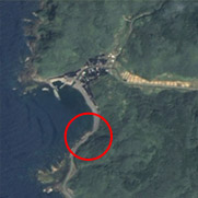
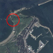
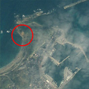
Disaster areas from the Noto Peninsula earthquake. The red circles indicate damage. In the image on the left, a road is closed due to a landslide, and in the right-hand image, brown soil is exposed after a landslide. (Left: near Monzenmachi-Fukami, Wajima-city, Ishikawa Prefecture/ Right: near Wajimazaki-machi, Wajima-city)

Yamashiro : When a disaster occurs, the police immediately begin rescue and evacuation operations. We call police activity at the time of disaster, including rescue, disaster security. The duties of the police are protecting national safety and keeping public order. Disaster security is an important element of these duties. When a disaster occurs, all the police forces across the country, even those whose jurisdiction is outside the disaster area, work together.
Disaster management has to be a national scheme. The Police, the Fire Defense, and the Self-Defense Forces are units led by the Disaster Prevention Bureau of the Cabinet Office. Various related ministries, agencies and self-governing bodies also participate. The whole country is united in this task. The core of the police mission during a disaster is to take action - our task is to rescue any citizens in danger as fast as possible.
Q. Could you describe your assignments in disaster management?
Yamashiro : I belong to the Office of Natural Disaster and Rescue. When a disaster happens, our office functions as a coordinator of overall police activities. For example, after the Noto Peninsula earthquake on March 25, 2007, we immediately contacted the prefectural police in Ishikawa and other prefectures to dispatch police officers to help, and provided them with guidance on disaster security. We also gathered information about the damage, and reported to the Prime Minister's Office. Basically, during disaster management, the government needs to be proactive, and it is part of our job to provide the Prime Minister's Office with up-to-date information.
Nagumo : At the Communications Operation Office of the Info-Communications Bureau, we operate communication systems for the police. When disasters happen, information in the form of audio and video is transmitted from disaster areas to prefectural police and the National Police Agency, and we are in charge of securing and providing the communication networks. For disaster management, prompt information delivery is key. In addition, we support police activity by analyzing satellite images of disaster areas and by feeding the information to national and prefectural police across the country.
Q. How do you hope satellites can assist with disaster management?
Yamashiro : First of all, I'd like to get information about disaster areas right away, because we have to make quick decisions on the number of police officers to dispatch. We want to obtain information as fast as possible, ideally within 30 minutes to an hour after the event has occurred. At minimum, even if satellites can help us assess a disaster area by satellite within a day, this will be a great help to the Fire Defense Agency and the Self-Defense Forces, as well as the police.
Another advantage of satellite images is their wide scope. A satellite can take images of places that humans cannot reach, so we can assess the situation even in remote in disaster areas. In the case of the Noto Peninsula earthquake, we have pinpointed the position of several landslides using pictures taken by the Advanced Land Observing Satellite Daichi (ALOS). Normally, we gather information on disaster areas using a helicopter-mounted camera that transmits images to the ground, but helicopters cannot fly in bad weather, so it's very useful to be able to get satellite images of areas we cannot access this way. I've heard that Daichi is designed for all weather, so I'm looking forward to getting its observations more often.
With JAXA's working group, we are also looking into potential satellite applications in non-disaster situations. Personally, I'd like to have access to three-dimensional maps. If we have a detailed library of images, we'll be able to assess disaster damage by comparing before and after shots. I hope to be able to use satellite images to better manage evacuation routes and refuge areas - so that we can find out whether roads are passable, whether buildings have collapsed, or whether emergency shelters are usable, for example.
Nagumo : Two different types of satellites are used for disaster management: communication satellites and Earth observation satellites. Both types help us collect audio-visual information on disaster areas. Some disaster areas cannot be reached by radio, which limits what we can find out, but with a satellite we instantly get a clear image of such areas. For instance, if a road is blocked, crews traveling by land cannot reach their destination, so it'll be very useful if we can detect such information from satellite images. Also, I hope that we'll eventually be able to transmit information via cellular-sized mobile ground stations and satellites, so that if ground networks go down, we can continue communications. I have heard that JAXA is currently testing this system. I hope it will come into practical use sometime soon.
Q. What needs to happen to improve disaster management with satellites?
Yamashiro : Increased speed and spatial resolution. An orbiting satellite cannot take images unless it is flying over the disaster area at the right time, so inevitably there is a time lag. As for spatial resolution, Daichi's is 2.5 meters, which is enough to assess mountainous areas, but not adequate in case of an earthquake in Tokyo, as more detailed information is required to assess damage to buildings and streets. Different resolution is necessary depending on the region and the population density. But in any case, higher resolution images are always appreciated.
Nagumo : I agree with Mr. Yamashiro. Frankly speaking, spatial resolution less accurate than one meter isn't really enough for our purposes. An advantage of satellites, though, is their ability to cover a wide area at once. In the Noto Peninsula earthquake, the Daichi satellite was able to take an image of the whole peninsula at once. I was impressed by this ability. On the other hand, it is a problem that in bad weather, we cannot get a sufficiently clear terrestrial image. Even though the Synthetic Aperture Radar (SAR) on Daichi is designed for all weather, its spatial resolution is 10 meters, so we cannot see the details of damage. Furthermore, in principle, an Earth observation satellite can take images only on specific dates, based on the satellite's orbit. This means the satellite cannot always respond to a disaster as quickly as we'd like. If these problems are solved, satellites will be much more useful in disaster management.
Q. Do you have any suggestions for JAXA's future?
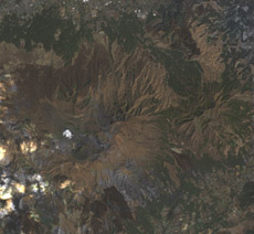
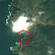
Pan-sharpened image of Mount Aso in Kyushu
Yamashiro : I have many hopes for Daichi, but I hope JAXA will launch even more advanced satellites in the future. The National Police Agency is in charge of managing all 47 prefectural police forces, but it is really they who go and do the work. I'd like to build a smoother communication flow for us to pass on information from JAXA to all the police forces across Japan, and I hope JAXA will establish a system that allows us to receive information 24 hours a day all through the year. One can never predict when and where a disaster will strike. Having a bank of satellite images of Japan will be very useful, as it will allow us to promptly compare with post-disaster images, and also will help improve disaster preparedness. Then, the police will see more clearly the value of satellite applications.
Nagumo : Currently, two-dimensional maps are used for disaster prevention, but I hope they will soon be replaced with satellite images. The advantage of a satellite image is its three-dimensional effect. For instance, on a regular map, a park is just a park - there is no information about what is there. On the other hand, satellite images reveal even the shapes of buildings in the park. It is very helpful to us if we can utilize a three-dimensional satellite image instead of a map with only contour lines. Another benefit of satellite images is the availability of frequently updated information. Maps, on the other hand, are rarely revised every year.
Communications satellites and Earth observation satellites are essential for disaster management. I'd like to see JAXA offer a variety of further enhanced satellite services. I also hope that they will develop satellites that can obtain images in any conditions, at any time. Also, rather than providing monochrome and color data separately, Daichi data will be used more efficiently and effectively, if its pan-sharpened images* are always available.
* Pan-sharpened images are high-resolution color images comprised of high-resolution monochrome images and low-resolution color images.
Yamashiro : First of all, I'd like to get information about disaster areas right away, because we have to make quick decisions on the number of police officers to dispatch. We want to obtain information as fast as possible, ideally within 30 minutes to an hour after the event has occurred. At minimum, even if satellites can help us assess a disaster area by satellite within a day, this will be a great help to the Fire Defense Agency and the Self-Defense Forces, as well as the police.
Another advantage of satellite images is their wide scope. A satellite can take images of places that humans cannot reach, so we can assess the situation even in remote in disaster areas. In the case of the Noto Peninsula earthquake, we have pinpointed the position of several landslides using pictures taken by the Advanced Land Observing Satellite Daichi (ALOS). Normally, we gather information on disaster areas using a helicopter-mounted camera that transmits images to the ground, but helicopters cannot fly in bad weather, so it's very useful to be able to get satellite images of areas we cannot access this way. I've heard that Daichi is designed for all weather, so I'm looking forward to getting its observations more often.
With JAXA's working group, we are also looking into potential satellite applications in non-disaster situations. Personally, I'd like to have access to three-dimensional maps. If we have a detailed library of images, we'll be able to assess disaster damage by comparing before and after shots. I hope to be able to use satellite images to better manage evacuation routes and refuge areas - so that we can find out whether roads are passable, whether buildings have collapsed, or whether emergency shelters are usable, for example.
Nagumo : Two different types of satellites are used for disaster management: communication satellites and Earth observation satellites. Both types help us collect audio-visual information on disaster areas. Some disaster areas cannot be reached by radio, which limits what we can find out, but with a satellite we instantly get a clear image of such areas. For instance, if a road is blocked, crews traveling by land cannot reach their destination, so it'll be very useful if we can detect such information from satellite images. Also, I hope that we'll eventually be able to transmit information via cellular-sized mobile ground stations and satellites, so that if ground networks go down, we can continue communications. I have heard that JAXA is currently testing this system. I hope it will come into practical use sometime soon.
Q. What needs to happen to improve disaster management with satellites?
Yamashiro : Increased speed and spatial resolution. An orbiting satellite cannot take images unless it is flying over the disaster area at the right time, so inevitably there is a time lag. As for spatial resolution, Daichi's is 2.5 meters, which is enough to assess mountainous areas, but not adequate in case of an earthquake in Tokyo, as more detailed information is required to assess damage to buildings and streets. Different resolution is necessary depending on the region and the population density. But in any case, higher resolution images are always appreciated.
Nagumo : I agree with Mr. Yamashiro. Frankly speaking, spatial resolution less accurate than one meter isn't really enough for our purposes. An advantage of satellites, though, is their ability to cover a wide area at once. In the Noto Peninsula earthquake, the Daichi satellite was able to take an image of the whole peninsula at once. I was impressed by this ability. On the other hand, it is a problem that in bad weather, we cannot get a sufficiently clear terrestrial image. Even though the Synthetic Aperture Radar (SAR) on Daichi is designed for all weather, its spatial resolution is 10 meters, so we cannot see the details of damage. Furthermore, in principle, an Earth observation satellite can take images only on specific dates, based on the satellite's orbit. This means the satellite cannot always respond to a disaster as quickly as we'd like. If these problems are solved, satellites will be much more useful in disaster management.
Q. Do you have any suggestions for JAXA's future?
Pan-sharpened image of Mount Aso in Kyushu
Nagumo : Currently, two-dimensional maps are used for disaster prevention, but I hope they will soon be replaced with satellite images. The advantage of a satellite image is its three-dimensional effect. For instance, on a regular map, a park is just a park - there is no information about what is there. On the other hand, satellite images reveal even the shapes of buildings in the park. It is very helpful to us if we can utilize a three-dimensional satellite image instead of a map with only contour lines. Another benefit of satellite images is the availability of frequently updated information. Maps, on the other hand, are rarely revised every year.
Communications satellites and Earth observation satellites are essential for disaster management. I'd like to see JAXA offer a variety of further enhanced satellite services. I also hope that they will develop satellites that can obtain images in any conditions, at any time. Also, rather than providing monochrome and color data separately, Daichi data will be used more efficiently and effectively, if its pan-sharpened images* are always available.
* Pan-sharpened images are high-resolution color images comprised of high-resolution monochrome images and low-resolution color images.
Hideshi Kozawa Satoru Nishikawa Tatsuya Yamashiro / Munehiro Nagumo Orbita Roswintiarti History of JAXA's Earth Observations