
Q. How does JAXA contribute to GEO’s Carbon Project?
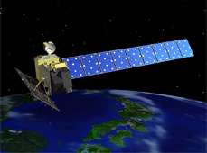
Advanced Land Observing Satellite DAICHI
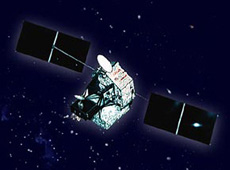
Greenhouse Gases Observing Satellite IBUKI
JAXA is involved in two elements of the GEO Carbon Project: Global Monitoring of Greenhouse Gases from Space, and Forest Carbon Tracking.
IBUKI is expected to contribute to Global Monitoring of Greenhouse Gases from Space. One of its features is the ability to measure carbon dioxide and methane on a global scale within three days, if the observed areas are not covered by clouds. So we expect that once we complete further verification of its performance, IBUKI will provide valuable data for this project.
DAICHI provides observation data for the Forest Carbon Tracking project. More specifically, in 2009 DAICHI created a classification image of the forest and non-forest areas of the globe with 10-meter resolution. It was the first satellite in the world to image all the forests of the Earth with such high resolution. Forests are crucial to curbing global warming because they absorb carbon dioxide. By measuring the world’s forest cover, we can find out how much carbon dioxide can be stored in forests, and this becomes very important when we think about global warming.
DAICHI is one of several satellites monitoring the world’s forests. These include the European Space Agency’s Envisat and others. We are working on verifying the consistency of the data from all these satellites by observing the same locations at the same time. We have reported these observation results to organizations such as the United Nations Framework Convention on Climate Change (UNFCCC.) Q. What kind of expectations do GEO members have of JAXA? Expectations are growing for data from JAXA’s satellites. In particular, DAICHI and IBUKI are highly rated by many GEO participating countries and organizations.
DAICHI not only contributes to climate studies through Forest Carbon Tracking; it has also been providing large amounts of data on natural disasters to the Sentinel Asia program, which monitors disasters in the Asia-Pacific area, and the International Disaster Charter, which performs global disaster monitoring. We also expect DAICHI to contribute to GEO’s work on ecosystems, agriculture and biodiversity. For example, just last fall a cooperation agreement was signed to use DAICHI for wetland research. Its data will be used in biodiversity research on birds that make their habitat in wetlands.
As for IBUKI, many requests are coming in from all over the world to use its data for climate change research and other projects.
Q. What are the benefits of the GEO Carbon Project?
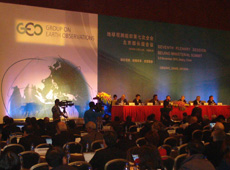
GEO ministerial summit, Beijing, November 2010
The results from the GEO project will benefit the Japanese satellite program in the future. JAXA has plans to launch satellites such as the Global Change Observation Mission (GCOM), the Global Precipitation Measurement (GPM), and the Earth Clouds, Aerosols and Radiation Explorer (EarthCARE). I think our experience and achievements with DAICHI and IBUKI will help these projects. To secure our budget, I think it is important for us to achieve positive results.
Since we are building links with other countries through GEO, I think it will be easier for us to cooperate internationally on future satellite projects. For instance, right now we have a big dilemma: what to do with the successor to IBUKI. At last year’s GEO ministerial summit in Beijing, there were discussions on future plans, including satellites being developed by other organizations. So now JAXA is negotiating with NASA and the ESA to coordinate plans for future carbon observation satellites. The negotiations will continue for a while, but I think such coordination is also a result of our participation in the GEO project.
And on top of that, I think it’s important, as an active member of the international community, to participate in political decisions on greenhouse gas reduction through GEO.
Q. How does JAXA want to contribute to the GEO Carbon Project in the future?
JAXA wants to continue to contribute to GEO in the future. Specifically, we would like to provide more data in the areas of disasters, climate and water. If you want people to use new data in a wide range of areas, first of all, you have to make it easy - to lower the barriers to entry. The data provider needs to provide support to the users. I think this is true for any kind of service. Unfortunately, in my personal opinion, I think JAXA’s satellite data hasn’t yet reached a stage where it is widely utilized. By making our Earth observation data freely available and encouraging its use, I think we can make it the international standard not just for GEO but for broader use as well.
Climate change is a big issue at the moment, so we would like to continue to perform forest monitoring and greenhouse gas observations using DAICHI and IBUKI to create positive results.
Osamu Ochiai
Associate Senior Administrator of Satellite Applications and Promotion Center, JAXA Space Applications Mission Directorate
Mr. Ochiai completed a master’s degree at the Graduate School of Environmental Science, Hokkaido University in 1994. At university he studied geophysics (meteorology). After graduation, he joined NASDA (former JAXA), and was involved in developing the data information service system for several Earth observation satellite missions, including the Advanced Earth Observing Satellite-II (Midori II) and the Advanced Land Observing Satellite DAICHI. In 2006, he was temporarily posted to the head office of the Group on Earth Observations as a architecture and data management expert for the Global Earth Observation System of Systems. He has been in his current position since 2009.
Researching the Carbon Dioxide Cycle
World’s First High-Resolution Global Forest/Non-Forest Map
Japan Contributes to Efforts to Solve Environmental Problems
Policymakers Worldwide Need Unified Carbon Cycle Data
Reliable Data Essential for Greenhouse Gas Reduction