First light Data for IBUKI-2's CAI-2
November 9, 2018 (JST)
National Research and Development Agency
Japan Aerospace Exploration Agency (JAXA)
After launch on October 29, 2018, IBUKI-2, the Greenhouse Gas Observing Satellite-2*1 has entered the in-orbit checkout phase*2. The first observations by its onboard Thermal and Near Infrared Sensor for Carbon Observation - Cloud and Aerosol Imager-2 (TANSO-CAI-2, hereafter CAI-2) was done on November 5 and 6 and captured images*3 as shown below.
Besides CAI-2, IBUKI-2's sensor suite contains the Thermal and Near Infrared Sensor for Carbon Observation – Fourier Transform Spectrometer. (TANSO-FTS) Measurement by TANSO-FTS alone could yield data discrepancy due to interference by clouds and aerosols, suspended particulate matter in the atmosphere. CAI-2 is therefore designed to detect the existence of clouds and the distribution of aerosols and to provide the data for their correction.
Compared to the original CAI onboard the IBUKI satellite launched back in 2009, CAI-2 has wider wavelengths and front and back viewing capabilities*4 for more detailed monitoring of the concentrations of PM 2.5, black carbon, and other types of aerosols.
Images 1 were constructed from first light data that CAI-2 returned, confirming the sound operation of CAI-2 instrument. Contrasting the CAI-2 data with the the CAI on the IBUKI recorded almost at the same time shows the Sensor's superior aerosol observation capabilities. CAI-2 gathers clear images as particles of dust were picked up and blown offshore to the Arabian Sea and black carbon caused by stubble burning in Northeast India traveled in the atmosphere. (See Attachment)
After the ongoing initial check-out phase of approximately 2.5 months, during which the science instruments are powered up and the instruments and satellite systems are evaluated, the mission will enter its science phase.
[Footnotes]
*1: IBUKI-2 is a satellite co-developed by three organizations: Japanese Ministry of Environment, National Institute of Environmental Studies, Japan and JAXA.
*2: An in-orbit checkout phase is the phase of satellite operation in which in-orbit function of the sensors, other instruments and satellite systems are evaluated.
*3: The images were collected during IBUKI-2 communications testing with the ground stations conducted on November 5 and 6, in Japan Time.
*4: The original IBUKI satellite only has nadir observation capabilities of clouds and aerosols.

Image 1: 460 spatial resolution images from the observation data captured by CAI-2 aboard IBUKI-2, at around 1 to 6 pm in Japan Time, November 5.
[Attachment]
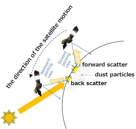
CAI-2 aboard IBUKI-2 has front and back viewing capabilities, an improvement from a nadir pointing view of the predecessor satellite instruments. This allows improved measurement of aerosols contained in dust. Image 2 shows dust plumes are stirred up southward past the Arabian Sea coast along the India-Pakistan border, around 6 pm, in Japan Time, November 5, 2018. The top left image (①), photographed by the forward-pointing camera, and the top right image (②) by the backward-pointing camera, are in ultraviolet light, ranged within the CAI-2 spectra. Both are made from the observation data on the right. For comparison, the bottom left (③) is the image obtained by CAI, the predecessor satellite instrument, around the same time.
IBUKI's CAI monitoring is limited to nadir observations, whereas CAI-2 collects more information as it monitors more scattering*5 from its forward and backward pointing observations. The CAI-2 instrument has a shorter wavelength ultraviolet band than CAI, which provides additional sensitivity for detecting dust properties.

Images 2: The Arabian Sea as captured by CAI-2 (right) and Iran-Pakistan coast. (left) ① is the image from CAI-2 forward pointing monitoring data and ② is the image from backward pointing monitoring data. ③ is the image from CAI nadir monitoring data.
|
*5: The same dust particles reveal different concentrations depending on the viewing angle. Dust particles in the atmosphere scatter light, and the effects tend to enhance in forward pointing monitoring data. This characteristic is identified in ② of Images 2, where the thin dust distribution surrounding distinguished plumes are monitored. The position of the satellite alters the images from the forward and backward pointing monitoring. |
|
|---|
With the additional ultraviolet region at 339nm, CAI-2 detects the properties of black carbon, a pollutant which causes global warming, suggesting the possibility of its quantitative monitoring. Top left image of Images 3 shows the columns of smoke possibly from stubble burning over Northeast India that CAI-2 detected at around 4:40 pm, in Japan Time, November 6, 2018. Smoke from this burning contains black carbon often called soot. It absorbs ultraviolet light more than it does visible light. The bottom image of Images 3 shows ultraviolet absorptions by black carbon. This image is produced by rationing visible light at 441nm and ultraviolet at 339nm. In this image, as the ultraviolet absorptions go stronger, the warmer the color.

Images 3: (Top) Image above Northeastern India as captured by CAI-2
(Bottom) Image of ultraviolet absorptions of the same region from CAI-2 observation data