Topics List
May 18, 2015 Updated
World Elevation Data (30-meter mesh version) is now available at JAXA's site free of charge!
|
JAXA will begin publishing free of charge an elevation data set that can express undulations of terrain over the world with a resolution of 30 meters horizontally (30-m mesh version). The data set has been compiled with images acquired by the "DAICHI" (ALOS). As the first step, we will offer the areas in East Asia, including Japan, and South East Asia regions, and will expand the areas to all over the world (within 82 deg. of N/S latitudes). |
|
|---|
Feb. 24, 2014 Updated
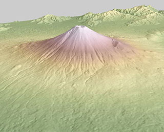
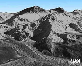
Precise Global Digital 3D Map "ALOS World 3D" Homepage
|
JAXA is starting to process the precise global digital 3D map using some 3 million data images acquired by the Advanced Land Observing Satellite "DAICHI" (ALOS). The digital 3D map to be compiled this time has the world's best precision of five meters in spatial resolution with five meters height accuracy that enables us to express land terrain all over the world. Hence its strong character will prove useful in various areas including mapping, damage prediction of a natural disaster, water resource research etc. |
|
|---|
Oct. 20, 2011 Updated
Last thank-you message to DAICHI from Japan Coast Guard
|
The land observing satellite "DAICHI," which completed its operations in May 2011, had contributed to the Japan Coast Guard (JCG) by providing satellite images of ocean ice for a long time. |
|
|---|
Aug. 19, 2011 Updated
DAICHI offers data for mapping the ice flow of the Antarctic ice sheet
|
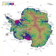
JAXA provided data acquired by the DAICHI’s onboard synthetic aperture radar for creating the world’s first ice flow speed map of Antarctica that has been compiled by the NASA Jet Propulsion Laboratory and the University of California, Irvine, utilizing data acquired through multiple numbers of synthetic aperture radars. Other organizations including the Canadian Space Agency and the European Space Agency also supply data. As a result, the ice flow speed distribution map for Antarctica was composed based on calculations using data obtained at different times by various satellites. The map will be beneficial for tracking climate changes and future forecasts of rising ocean surfaces. |
 |
|---|
May 12, 2011 Updated
DAICHI operations completed
|
JAXA had been trying to communicate with the Advanced Land Observing Satellite “DAICHI” (ALOS) for about three weeks after its power generation anomaly on April 22, but we decided to complete its operations by sending a command from the ground to halt its onboard transmitter and batteries at 10:50 a.m. on May 12 (Japan Standard Time) as we found it was impossible to recover communication with the satellite. |
 |
|---|
Apr. 22, 2011 Updated
DAICHI (ALOS) Power Generation Anomaly
|
JAXA has been operating the Advanced Land Observing Satellite "DAICHI" (ALOS) exceeding its design life of three years, and even after its target life of five years. However, at around 7:30 a.m. on April 22, we found that the satellite shifted its operation mode to the low load mode, and all the onboard observation devices were turned off due to power generation precipitation. The anomaly was detected through relayed data via the Data Relay Test Satellite "KODAMA." |
 |
|---|
Feb. 25, 2011 Updated
Glacial Lake Inventory in Bhutan using DAICHI data released
|
JAXA released the Glacial Lake Inventory of 10-meter accuracy on its website for the first time. The inventory was compiled using observation data of the Advanced Land Observing Satellite "DAICHI." JAXA has been conducting the research on glacial lake outburst floods in Bhutan Himalaya ("Bhutan GLOF project") supported by the Japan Science and Technology Agency (JST) and the Japan International Cooperation Agency (JICA) in corporation with the Department of Mineral and Geology (DGM) of the Royal Government of Bhutan and other domestic institutions to understand the status quo of the glacier. |
 |
|---|
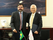
Nov. 8, 2010 Updated
JAXA and INPE Signing Letter of Intention in cooperation for REDD+ using DAICHI
|
JAXA and the Instituto Nacional de Pesquisas Espaciai (INPE), a Brazilian national space research institute, signed a Letter of Intention (LOI) to cooperate in the program on Reducing Emissions from Deforestation and Forest Degradation in Developing Countries (REDD+)*1 using the JAXA’s Advanced Land Observing Satellite “DAICHI.” |
 |
|---|
Oct. 21, 2010 Updated
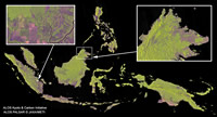
Global Forest/Non-forest map using ALOS/PALSAR
|
The Japan Aerospace Exploration Agency (JAXA) has generated the world’s first 10-meter resolution images and maps of the global forest and non-forest area distribution (in 2007 and 2009) using the Phased Array type L-band Synthetic Aperture Radar (PALSAR) aboard the Advanced Land Observing Satellite “DAICHI” (ALOS,) and will publish them on our website. We would also like to inform you that we will introduce the image maps at a side event for the 10th Conference of the Parties (COP 10) to the Convention on Biological Diversity and also at the Ministerial Summit for the Group on Earth Observation (GEO) to be held in Beijing in 2010. We will analyze and process past data to understand global-scale forest carbon volume change to compile useful data for control measures to tackle deforestation and forest deterioration, while continuing forestry observation by the PALSAR. For data distribution, we will conclude an agreement with cooperative organizations. |
 |
|---|
Oct. 18, 2010 Updated
Agreement on wetland survey by DAICHI with Ramsar Convention Secretariat
|
On October 18, JAXA and the Ramsar Convention Secretariat participated in the 10th Conference of the Parties (COP 10) to the Convention on Biological Diversity entitled "The role of the Ramsar Convention in the implementation of the Convention on Biological Diversity," and agreed to cooperate in a global survey of the Wetlands of International Importance through the use of the Advanced Land Observing Satellite "DAICHI." We have since signed the cooperation agreement. |
 |
|---|
Sep. 3, 2010 Updated
JAXA Contribution to Pakistan Flood Rescue Activities Based on the Letter of Intent with Asia Development Bank
|
The heaviest flooding has been occurring along the Indus River in north-west Pakistan since the end of July, and JAXA has been carrying out emergency observations on the disaster-stricken areas according to a request by Sentinel Asia and the International Charter on Space and Major Disasters. |
 |
|---|
May 13, 2010 Updated
JAXA received a letter of appreciation from GEO for data provision on the Haiti and Chile earthquakes
|
JAXA carried out emergency observations on disaster stricken areas following major earthquakes in Haiti, on 12 January, and Chile, on 27 February, by using DAICHI. JAXA then provided essential data to concerning international organizations through the International Charter "Space and Major Disasters." On this account, Dr. Jose Achache, Director of the Group on Earth Observations, handed a special letter of appreciation to Dr Masanori Homma, Executive Director of JAXA. |
 |
|---|
Apr. 13, 2010 Updated
Data Transmission Operation between DAICHI and NASA TDRSS
|
Based on the collaboration agreement between JAXA’s Advanced Land Observing Satellite “DAICHI” and NASA’s Tracking and Data Relay Satellite System concluded in June 2009, observation data acquired by DAICHI over the North and South America can be sent to NASA ground stations through the TDRSS, then transmitted to JAXA’s Earth Observation Center (EOC) via the Internet. |
 |
|---|
Mar. 30, 2010 Updated
Cooperation with Mie, Kochi, and Tokushima prefectures for disaster preparation verification using satellites.
|
Feb. 25, 2009 Updated
DAICHI completes regular operation phase
|
The DAICHI, launched on January 24, 2006, completed its three-year regular operation phase, and entered the post operation phase. |
 |
|---|
Dec. 2, 2008 Updated
JAXA and UNESCO concluded Memorandum of Unity for Monitoring World Heritage Sites
|
JAXA and the United Nations Educational, Scientific, and Cultural Organization (UNESCO) concluded a Memorandum of Unity (MOU) for cooperating in monitoring World Heritage Sites using the "DAICHI" to watch and protect the common legacy of all mankind. |
 |
|---|
Aug. 18, 2008 Updated
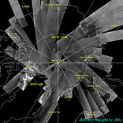
Images of the Arctic and Antarctic Circles acquired by the DAICHI
|
JAXA has been regularly observing the Arctic and Antarctic Circles as the two years between March 1, 2007, and March 1, 2009, are the International Polar Years. We are happy to announce that we have published on our website some of the images acquired by the Phased Array type L-band Synthetic Aperture Radar (PALSAR), one of the sensors onboard the DAICHI. |
 |
|---|
Jul. 28, 2008 Updated
Thank you letters from China's disaster-related organizations concerning Sichuan earthquake
|
On May 13, 2008, JAXA carried out an emergency observation using our Advanced Land Observing Satellite, "DAICHI," on the disaster-stricken area in Sichuan Province in China, where a major earthquake struck on May 12, 2008, in order to contribute to the post-disaster rescue operations there. We received thank you letters from two Chinese disaster-related organizations, the China National Committee for Disaster Reduction (CNCDR) and the National Disaster Reduction of China (NDRCC), to whom we provided our data. |
 |
|---|
Jul. 1, 2008 Updated
Forest observation images taken by "DAICHI"
|
JAXA decided to publish images on the Internet that were acquired by the "DAICHI" as part of the on-going forest observation project. The image data that covers forests, swamps and deserts all over the world are processed into a 50-meter resolution map. They were acquired by the Phased Array type L-band Synthetic Aperture Radar (PALSAR) onboard the DAICHI. The maps were compiled in cooperation by JAXA, the European Union research institute, and other organizations that participate in the Kyoto and Carbon Initiative. |
 |
|---|
Jun. 3, 2008 Updated
Daichi succeeded in communication experiment with US data relay satellite
|
JAXA carried out a communication experiment with the University of Alaska on May 30, 2008, (Japan Standard Time) and successfully sent observation data from the "Daichi" to the NASA White Sands Test Facility via a US data relay satellite, the "Tracking and Data Relay Satellite F-10 (TDRS-F10.)" This is the world's first data transmission test of this kind. |
 |
|---|
Apr. 18, 2008 Updated
"Daichi" will provide advanced Data to better adapt to climate threats in Latin America and the Caribbean
|
April 17, 2008 -Up-to-the-minute-data and expertise derived from the Advanced Land Observation Satellite "Daichi "(ALOS) developed and operated by the Japan Aerospace Exploration Agency (JAXA) will contribute a better formulation of measures to adapt to climate change threats in Latin America and the Caribbean, according to an agreement signed today between JAXA and the World Bank. |
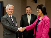 (Courtesy of World Bank, Photo: Debroah Campos) |
|---|
Mar. 14, 2008 Updated
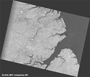
Observation of High-Wave Damage on the East Coast of Toyama Prefecture by the "Daichi"
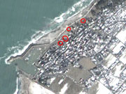
|
High waves along the coast of the east part of Toyama Prefecture on Feburary 24, 2008, destroyed the high-wave protection gate in Nyuzen-cho and houses in the surrounding area were also damaged. The photo is a composition (pan-sharpened) image made from data observed on February 22 (before) and February 25 (after) by the PRISM and AVNIR-2. The red circles indicate deciphermented places where the houses were destroyed. |
|
|---|
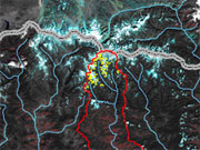
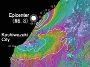
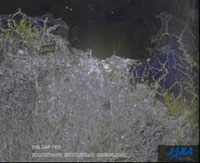
Jul. 20, 2007 Updated
Niigata-ken Chuetsu Offshore Earthquake observation by PALSAR
|
A huge earthquake occurred off Jyo-chuetsu, Niigata Prefecture (60 kilometers south-west of the city of Niigata), at about a depth of 17 kilometers at 10:13 a.m. on July 16, 2007 (JST.) The earthquake was named the "2007 Niigata-ken Chuetsu Offshore Earthquake." The Japan Aerospace Exploration Agency (JAXA) analyzed observation images acquired by the Advanced Land Observing Satellite "Daichi" (ALOS) on July 19 and confirmed the pattern of diastrophism. |
 |
|---|
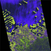
Feb. 14, 2007 Updated
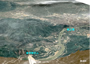
Indonesian Flood observation by PALSAR
|
The largest flood since 2002 occurred in the Indonesian capital, Jakarta, on Feb. 2
|
 |
|---|
Feb. 8, 2007 Updated
Letters of Agreement between JAXA and Tokai University
|
On January 28 (Sun), JAXA and Tokai University exchanged Letters of Agreement to directly receive data from the Advanced Land Observing Satellite (ALOS) and to cooperate in research for data use and the development of earth observation systems. |
 |
|---|
Oct. 26, 2006 Updated
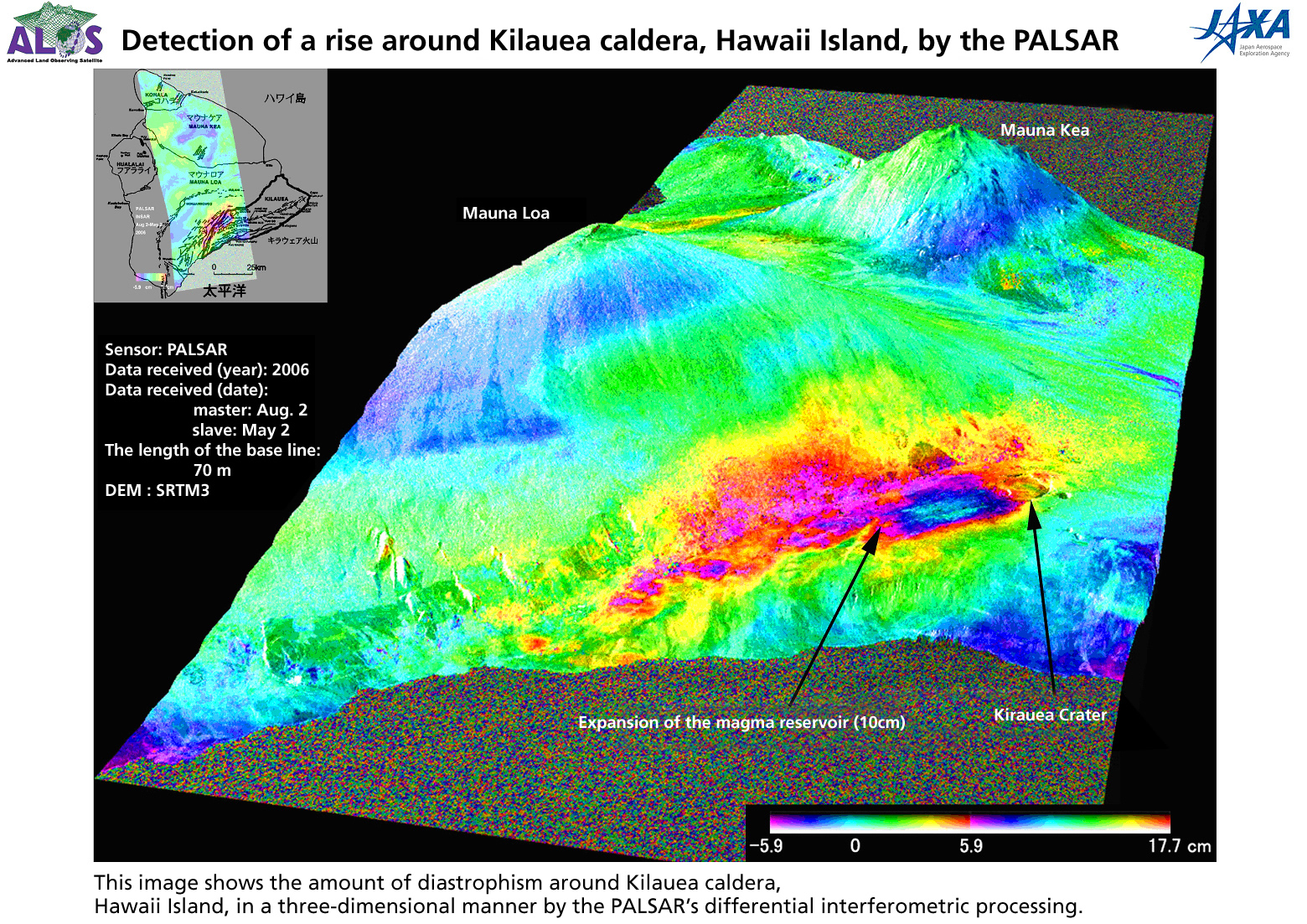
"Daichi" satellite confirms rise in earth's surface due to magma activities by analyzing PALSAR observation images on Kilauea, Hawaii
|
According to the "differential interferometric processing" (*) of observation images acquired by the PALSAR onboard the "Daichi" on the south part of Hawaii Island, Hawaii, USA, the five-meter diameter area around the south-west part of the Kilauea volcanic crater rose about 10 cm in three months between May 2 and Aug. 2, 2006, because of the expansion of a magma reservoir.
|
  |
|---|
Oct. 24, 2006 Updated
Start of Operations Phase and Data Provision to the Public
|
The Advanced Land Observing Satellite "Daichi (ALOS)" launched on January 24 this year (Japan Standard Time, JST) moved on to the operations phase on Oct. 24. Along with the start of the operations, observation data (called "ALOS data") from the "Daichi" will become available to domestic and overseas organizations. JAXA also started providing data to the Sentinel-Asia, which JAXA and other related organizations are currently establishing as a disaster preparation system in Asia. |
|
|---|
Jan. 28, 2006 Updated
Daichi (ALOS) completes critical phase
|
As previously announced, the Daichi had put itself into safety mode because of the anomaly detection. We carried out operations to have the Daichi return to normal operations, and verified that all function of the satellite are working normally. JAXA then decided to complete the critical phase at 5:00 p.m. on Janunry 28 (JST) and moved onto the initial functional verification phase. |
 |
|---|
Jan. 28, 2006 Updated
The critical phase of Daichi extended
|
At 10:51 p,m. on the 27th (JST), an anomaly detection function was activated for the data processing system and Daichi consequently put itself into safety mode. |
|
|---|
Jan. 26, 2006 Updated
Deployment of the Antenna for the Phased Array Type L-band Synthetic Aperture Radar (PALSAR)
|
The Japan Aerospace Exploration Agency (JAXA) started the deployment of the Antenna for the Phased Array Type L-band Synthetic Aperture Radar (PALSAR) from 10:23 a.m.(Japan Standard Time, JST), and confirmed that it had been successfully completed through telemetry data received at 12:09 p.m.(JST.) |
 |
|---|
Jan. 25, 2006 Updated
Deployment of the Data Relay Satellite Communication Antenna (DRC) for the Advanced Land Observing Satellite "Daichi" (ALOS)
|
The Japan Aerospace Exploration Agency (JAXA) started the deployment of the Data Relay Satellite Communication Antenna (DRC) of the Daichi from 9:37 a.m., January 25(Japan Standard Time, JST), and confirmed that it had been successfully completed through telemetry data received at 9:44 a.m. January 25 (JST). |
 |
|---|
Jan. 24, 2006 Updated
Solar Array Paddle (PDL) Sun Tracking Status
|
The Japan Aerospace Exploration Agency (JAXA) confirmed that the sun tracking for the satellite solar array paddle (PDL) of the Daichi is normal through signals received from the Daichi at the Perth station in Australia. Its power generation is also normal. The station started receiving the signals at 12:31 p.m. (Japan Standard Time, JST) at the time of the revolution. |
 |
|---|
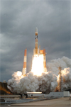
Jan. 24, 2006 Updated
Launch Result of "Daichi" (ALOS) / H-IIA F8
|
The H-IIA Launch Vehicle No. 8 (H-IIA F8) with the Advanced Land Observing Satellite "Daichi"(ALOS) onboard was launched at 10:33 a.m. on January 24, 2006 (Japan Standard Time, JST.) The initial flight angle (azimuth) was 115 degrees. |
 |
|---|
Nov. 22, 2005 Updated
Third tracking and control rehearsal for the ALOS
|
|
 |
|---|
Oct. 25, 2005 Updated
Launch site operations are in progress at TNSC
|
|
 |
|---|
Apr. 5, 2005 Updated
Final electric performance test on ALOS
|
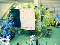
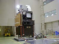
Following the thermal vacuum test that took a month, the ALOS is now undergoing its final electric performance test. This test is to make sure that the electric performance and function of each piece of satellite equipment that were verified by the initial electric performance test have not deteriorated after the various environmental tests, namely vibration, acoustic, shock, and thermal vacuum tests. The ALOS will be visually inspected for the last time after this final electric performance test, and the ALOS team will prepare to transport the satellite to the Tanegashima Space Center. |
 |
|---|
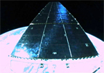
Feb. 22, 2005 Updated
ALOS undergoes thermal vacuum test
|
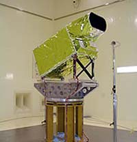
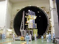
The ALOS team has almost completed inspections, modifications, and additional verifications for ensuring a succesful mission, and is now carrying out a thermal vacuum test. The ALOS is scheduled to be launched sometime in the next fiscal year. The photo shows the satellite in a 13-meter diameter vacuum chamber just before the door was closed. The thermal vacuum test is to verify the electrical performance and thermal design of the satellite under a simulated space environment. The test will be followed by a final electric performance test and shipping preparations to Tanegashima Space Center. |
 |
|---|
Mar. 9, 2004 Updated
ALOS undergoing system checkup
|
After the successive failures of our projects last year, JAXA is re-examining satellites, and ALOS is not an exception. ALOS, which is scheduled to be launched in the next Japanese fiscal year, is currently undergoing a system checkup. |
 |
|---|
Dec. 26, 2003 Updated
ALOS is now under a system proto-flight test starting with an initial functional verification and mass property test.
|
ALOS is now under a system proto-flight test starting with an initial functional verification and mass property test. |
 |
|---|
Nov. 18, 2003 Updated
Compatibility Test with Ground Equipment and System Proto-Flight Test
|
compatibility test with ground equipment of the Earth Observation Center (EOC) was a rehearsal for processing data sent from the ALOS on the ground. |
 |
|---|
Apr. 17, 2003 Updated
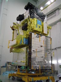
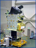
ALOS: about to complete the assembly to be ready for the proto-flight test this summer
|
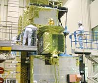
The assembly and integration tests of the ALOS Proto-Flight Model (PFM) are currently in progress at the Spacecraft Integration and Test Building (SITE) in the Tsukuba Space Center (TKSC). |
 |
|---|
Oct. 16, 2002 Updated
|
The integration and testing of the ALOS Proto-Flight Model (PFM) is currently in progress at the TSUKUBA Space Center. |
 |
|---|
Aug. 29, 2002 Updated
ALOS for WSSD
|
In the "World Summit on Sustainable Development" held in Johannesburg, South Africa, NASDA makes presentations on satellite-based earth observation and the utilization of observed data as a part of Japanese contributions. |
 |
|---|
Jul. 10, 2002 Updated
|
The ALOS Proto-Flight Model (PFM) was delivered to the TSUKUBA Space Center. |
 |
|---|
Jun. 5, 2002 Updated
|
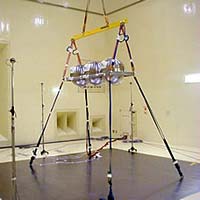
The deployment test of the ALOS's Solar Array Paddle (PDL) for its Proto-Flight Model (PFM) was conducted at the NTSpace Komukai Works. |
 |
|---|
Apr. 12, 2002 Updated
|
A deployment test using the Proto-Flight Model (PFM) of the data relay antenna was conducted at the Tsukuba Space Center. |
 |
|---|
Feb. 27, 2002 Updated
|
An acoustic test using the Proto-Flight Model (PFM) of the Panchromatic Remote Sensing Instrument for Stereo Mapping (PRISM) was conducted at the Tsukuba Space Center. |
 |
|---|
Feb. 8, 2002 Updated
|
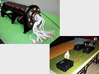
A field test using the Engineering Models (EM) of the Star Tracker (STT) and the On-board Attitude Control Computer (AOCE) was conducted at the Institute of Space and Astronautical Science (ISAS) Usuda Deep Space Center (UDSC). This field test is an important step for the Attitude and Orbit Control Subsystem (AOCS) to confirm its performance of star identification and attitude determination with real-sky stars. Usuda is far away from towns and has good starry sky with good weather and without atmospheric disturbance. In addition, this field test was held in the term of a new moon. |
 |
|---|
Dec. 10, 2001 Updated
|
The developments of ALOS PFM (Proto-Flight Model) components are being completed one after another. |
 |
|---|
Nov. 12, 2001 Updated
|
At the Tsukuba Space Center, a sound test on the fuel tanks for the Proto-Flight Model (PFM) was conducted. |
 |
|---|
Oct. 19, 2001 Updated
|
The Proto-Flight Model (PFM) electric source bus devices were completed and delivered to NASDA. |
 |
|---|
Oct. 5, 2001 Updated
|
At the Tsukuba Space Center, a Thermal Vacuum Test was conducted for the ALOS's radio sensor PALSAR (Phased Array type Synthetic Aperture Radar) Proto-Flight Model (PFM). |
 |
|---|
Sep. 4, 2001 Updated
|
Sounding Test for Protoflight Model for a hood part of Star Image Sensor Equipment. (STT) |
 |
|---|
Jul. 25, 2001 Updated
|
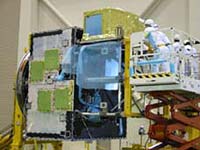
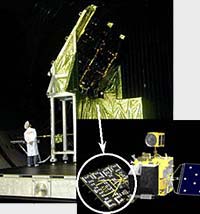
At the Tsukuba Space Center, a Thermal Vacuum Test for the AVNIR-2 Proto Flight Model(PFM), which is an optical sensor, was conducted. AVNIR-2 in the Vacuum Chamber observed a light in a regular pattern that is emitted from the test equipment outside the chamber, and verified the designed performance for space environment. Photo shows the preparation for testing, and AVNIR-2 is composed of Scanning Radiometer Unit (Upper Right) and Electrical Unit (Lower Left). |
 |
|---|
Jul. 12, 2001 Updated
|
ALOS Project verified to start manufacturing and maintenance design phase through the Critical Design Review (CDR). Currently, onboard devices are manufacturing and some completed conponents are sequentially assembled to the main structure of ALOS (the reference in Topics May 2001). This diagram is the prospects of ALOS on orbit, based on the current design. |
 |
|---|
May 7, 2001 Updated
|
The above photograph is the main structure of The ALOS Proto-flight Model (PFM) in manufacturing. As the ALOS's structure, this truss is going to be assembled with panels, to which various components and observation sensors will be attached. After completing the assembly, we will conduct a variety of tests toward the launch of JFY 2003. |
 |
|---|
Feb. 20, 2001 Updated
|
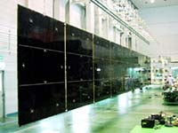
We conducted a series of radio performance tests for the PALSAR engineering model (EM) of ALOS at the Tsukuba Space Center. The photo shows single panel being tested, but in orbit, four panels folded will be deployed to the approximate size of 3m x 9m. This test verified PALSAR's performance as a radar, and now we start the manufacturing of a PFM (proto-flight model), which will actually fly in orbit. |
 |
|---|
Jun. 9, 2000 Updated
|
This picture shows the Thermal Test Model (TTM) of ALOS. We have introduced the Mechanical Test Model (MTM) in the previous topics. Can you tell the difference between TTM and MTM? Those parts in golden, silver, and black parts are thermal control material called MLI and OSR. Their function is to insulate heat or radiate heat so that the satellite will function normally in the thermal environment on orbit. In other words, a space suit for the satellite. |
 |
|---|
May 19, 2000 Updated
|
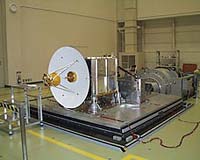
This photograph shows an overview of ALOS system MTM (mechanical test model) in a vibration test. (Front side in the photo is the earth direction.) The test was successfully completed and we confirmed that ALOS would withstand H-IIA's launch environment. With this test, mechanical test by MTM was completed and we will proceed to the verification of thermal design using TTM (thermal test model). |
 |
|---|
Apr. 14, 2000 Updated
|
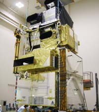
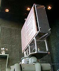
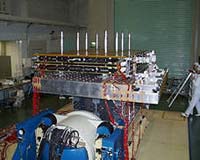
The picture is ALOS system MTM (mechanical test model). ALOS is a Large satellite with 6.5m in height, 4m in width, and 4ton in weight. The satellite's flight direction is up in this picture and earth direction is to the right. Satellite's upper part is PRISM (the inclined box is one of PRISM's radiometers), the blown panel shown in the front is PALSAR, and the equipment attached to the side of the earth direction is AVNIR-2. This photograph shows MTM in an acoustic test. We finished the acoustic test without any problem and are planning to have a vibration test next. |
 |
|---|
Feb. 15, 2000 Updated
|
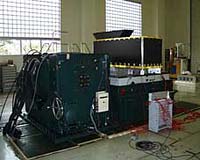
At Tsukuba Space Center, we conducted a vibration test on the MTM (mechanical test model) antenna panel of PALSAR, which is a radio sensor to be embarked on ALOS. |
 |
|---|
Nov. 12, 1999 Updated
|
We conducted the vibration test on the mechanical test model of data relay antenna by large scale vibration test device in Spacecraft Integration and Test Facilities (SITE) at Tsukuba Space Center. The durability of this antenna in the state of vibration which occurs at launching of ALOS was confirmed from the result of the test. |
 |
|---|
Sep. 3, 1999 Updated
|
The Vibration Test of AVNIR-2, one of the onboard sensors of ALOS, has been conducted using mechanical test model at Tsukuba Space Center. The test aims to confirm that AVNIR-2 is capable to sustain the vibration environment in lift-off and in-flight phase. |
 |
|---|
Jul. 26, 1999 Updated
|
We are now conducting the Preliminary Design Review (PDR) at each onboard instrument. PRISM, one of the remote-sensing instruments of ALOS, is a panchromatic radiometer with 2.5-meter spatial resolution. We finished testing of Bread Board Model (BBM), and are now producing its Engineering Model (EM). |
 |
|---|