 |
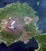
 Pan-sharpened image of Mt. Merapi (A) and the vicinity of Yogyakarta (B) in Indonesia, observed by Daichi Pan-sharpened image of Mt. Merapi (A) and the vicinity of Yogyakarta (B) in Indonesia, observed by Daichi The vicinity of Nagoya, Aichi, observed by Daichi The vicinity of Nagoya, Aichi, observed by Daichi |
Q. What do you think is the significance of observing the Earth from space?
I think the significance of Earth observation is the capability of monitoring global environmental changes, which have accelerated lately. To understand these changes and to be able to issue warnings as necessary, we need accurate sensors, objective evaluation, effective analysis, and reliable results. I think that all the techniques and technologies we have accumulated since the 1980s have enabled us to get to the point we are at today: we have stable sensors on orbiting satellites that allow us to get consistent and reliable results from repeated observation covering wide regions.
We are now able to see how the Earth has been changing in the short term and in the long term. There are, of course, some technical problems to overcome, such as the influence of the fluctuation of the atmosphere when it comes to measuring changes in the shape of the Earth's crust. But relatively speaking, I think we are getting close to our final goal. Even though we still have a long way to go in determining the biomass of forests with more than 60 tons per hectare, this challenge is also inspiring to me. I think there is significance in continuing Earth observation because there is an opportunity to solve technical challenges.
Q. What is the attraction of data analysis?
Data analysis allows us to "feel" various phenomena on Earth, or I should say "expressions" of the Earth, such as the flow of winds, through images. And thanks to the development of new analysis technologies, it's possible to visualize these expressions more effectively. Developing new algorithms is not easy - it takes time and a lot of trial and error. Satellites degrade over time, and develop very strange distortion in their observations. But it's a wonderful feeling to succeed in reviving data by improving processing algorithms, after meticulously analyzing the observation data and figuring out the rules for calibration. Also, I'm very happy when I succeed in increasing processing speed by improving the software. It's very satisfying when good results follow a solid effort, and that's true in everything, not just in the world of data analysis.
Q. What kind of observation or research would you like to conduct in the future?
With Daichi, I'm interested in geophysical phenomena, or, more precisely, the ionosphere. I'd like to study the density of the ionosphere as it varies according to place and time. Secondly, I hope to reduce the influence of the atmosphere on the satellite's differential interferometric processing. And thirdly, I'd like to observe the ground surface moving. For instance, the Indochina peninsula is a result of the collision of the Himalayas and India's Deccan Plateau, apparently extending eastward by several centimeters per year. I'm very interested in seeing this kind of crustal movement. And as we have free access to data from foreign agencies, I want to be able to offer foreign nations diastrophic and disaster forecasts in return.
Now, in terms of the overall field of Earth observation, I'm keen to keep broadening my experience with SAR. I have been involved in research and development for aircraft SAR, and utilization research for satellite SAR. As computer performance improves every year, ever greater possibilities are opening up, with faster processing speeds allowing us to use software and algorithms that can analyze more data in detail. So I'd like to improve results using continually improving processors and SAR.
Another project I'm considering is measuring tree height on a global scale. Using Daichi radar, we can get an idea about biomass from the shading of its images, but we are limited to trees with a height of around 5 meters. It's possible to determine biomass by estimating the height and types of trees, so if radar for such a purpose is developed someday, I think we'll be able to view the global distribution of tree height, which will consequently enable us to make a biomass distribution map. I'm very keen on this idea. Also, while we further our knowledge of Earth, I'd love to send SAR into lunar orbit to study changes in the lunar surface, and explore the moon for natural resources.
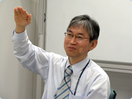
Dr. Shimada is an ALOS Science Manager at the Earth Observation Research Center (EORC), which is part of the Office of Space Applications at JAXA, and a Doctor of Engineering.
He graduated from the Department of Aerospace Engineering at Kyoto University in 1977, and received an M.Eng. from the university in 1979. In the same year, he joined the National Space Development Agency of Japan (now part of JAXA).
Since then, Dr. Shimada has worked on the development of microwave scatterometers at the Tsukuba Space Center, ground facility development for the JERS-1 satellite, and SAR applications research at EORC. He conducted research on accurate measurement of backscattering coefficient, and received a Ph.D. from the University of Tokyo in 1999. Dr. Shimada is a member of the IEEE Geoscience and Remote Sensing Society, a Director of the Remote Sensing Society of Japan, and a Visiting Professor of Tokai University.
He specializes in microwave remote sensing, SAR processing, interferometric SAR, and analysis of alternating polarization SAR.
| 1 2 3 4 |
