Q. DAICHI and ALOS-2 both use L-band SAR. Why is that important?
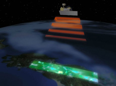
Crustal deformation caused by an eruption of Mount Shinmoe, imaged by PALSAR aboard DAICHI. The image indicates that sedimentation has occurred within the red circle.
![]()
Japan is the only country that has flown satellites with L-band radar.
Radar satellites have three different kinds of bandwidth: L band (1 GHz), C band (5 GHz), and X band (9 GHz). L band has the lowest frequency. The advantage of using low-frequency radar is, for example, that radio waves can penetrate even a deep forest with many fallen leaves, to reach the ground and bounce back. This enables us to track the movement of the earth’s crust, which is important for a country like Japan, where there are many earthquakes.
Q. When a disaster has happened, there is a great need for immediacy. Are there any improvements on that point?
Of course it is important to receive satellite data promptly. ALOS-2’s transmission rate has been improved to 800 Mbps, five times faster than that of DAICHI, so it will be possible to acquire data on a disaster in Japan almost in real time.
Q. Are you attempting anything new with ALOS-2?
One of the things that have helped us improve ALOS-2’s resolution is a new material called gallium nitride (GaN). I said earlier that ALOS-2 can output stronger radio waves. We’ve achieved this by using gallium nitride in the transmitter. It’s the first time this material is being used in space.
Gallium nitride not only allows enhanced radio-wave output but also releases less heat. That means the satellite consumes less power, which can lengthen its lifespan. Some people may think using a new material is a risk, but after conducting a good number of experiments, we were convinced it would work.
Q. Aside from disaster management, how will ALOS-2 be used?
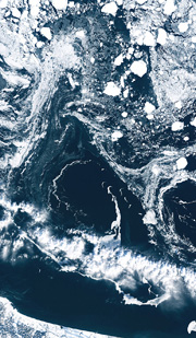
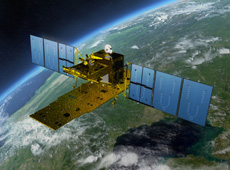
Drift ice in the Sea of Okhotsk, observed by DAICHI
![]()
I think that ALOS-2 can be used for a wide range of purposes. For example, the Japan Coast Guard used DAICHI observation data to provide updates on the status of sea ice. The coast guard released maps indicating the locations of sea ice to ensure safe navigation in the Sea of Okhotsk in winter. ALOS-2 will make observations more frequently than DAICHI, so it will become possible to provide near real-time information.
Also, we have a request to resume monitoring of illegal deforestation in Brazil, which DAICHI used to do, because since the very moment DAICHI stopped working and the monitoring was over, the practice has increased. This shows that monitoring with the use of DAICHI had served as a great deterrent.
Q. Are there any plans for international collaboration using ALOS-2?
Some information cannot be acquired without satellites that can perform extensive observations from space. From this point of view, ALOS-2’s observations should be considered an important national measure, for the benefit of Japan and the rest of the world.
I explained earlier that there are different bandwidths for different types of synthetic aperture radar. I believe that we can get more detailed information on disasters when satellites with unique features cover different wavelengths and complement each other. As a matter of fact, after the Great East Japan Earthquake last year, we were given a number of very useful images from foreign radar satellites. At the same time, we have received many requests from abroad for our L-band images.
In addition to collaboration through the International Charter and Sentinel Asia, we have begun to build a collaborative relationship between ALOS-2 and foreign radar satellites to improve emergency disaster monitoring.
Q. What is the current development status of ALOS-2?
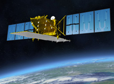
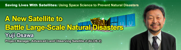
Advanced Land Observing Satellite-2 (ALOS-2)
DAICHI was launched in 2006, and the conceptual design for ALOS-2 started in 2007. We have gone through many ideas, designs and tests since then, and now we are finally at the stage of assembling the ALOS-2 satellite. We will surely still face challenges, but development is going relatively smoothly and on schedule.
I worked on the development of DAICHI for 12 years, so when I saw the images it took, I had tears of joy. And now I am committed to making sure that ALOS-2 and ALOS-3 are equally successful.
Q. What kind of satellite are you planning after ALOS-2?
There were two types of DAICHI users: those who mainly used its optical sensors and those who mainly used its radar. Optical sensors are like a digital camera – they can take color pictures, but they cannot see the ground when there are clouds. Radar, on the other hand, uses radio waves, so it can observe the Earth’s surface through clouds. For example, it can see when a flat surface becomes uneven after a crustal deformation caused by an earthquake. However, radar can provide only black and white images.
I think color pictures are easier to look at and of course preferred by the general public, but really, optical sensors and radar are both essential. So we are now looking into equipping ALOS-3 with optical sensors.
Q. Finally, could you tell us about your vision for the future?
My major job for now is to launch ALOS-2 in Fiscal Year 2013 as originally planned, on schedule. I aim to launch it safely and to have more users than DAICHI did.
If we can launch ALOS-3 while ALOS-2 is still in operation, we will be able to get more precise observations by using the two satellites at the same, and combining data from radar and optical sensors. At the moment, we are making prototypes of optical sensors for ALOS-3. I’m keeping my fingers crossed that a budget for ALOS-3 will be secured so that the project can go forward. And I would like it to lead to the development of follow-up missions ALOS-4 and ALOS-5.
Earth observation satellites such as ALOS are becoming absolutely necessary infrastructure in our society – as much as weather satellites. If weather satellites suddenly went out of order, our life would be more difficult. Similarly, it is important that Earth observation satellites continue observations on a steady basis. I would like to continue working to make sure such satellites operate smoothly in the future.
Associate Principal Engineer, ALOS-2 Project Manager, Space Applications Mission Directorate, JAXA
Mr. Osawa received his master’s degree in electrical and communication engineering in 1986, from the Graduate School of Engineering at Tohoku University. After graduation he joined the National Space Development Agency of Japan (now JAXA). His early work included remote sensing research at the Earth Observation Center. Subsequently, he was responsible for the development (optical sensors and system) of the Advanced Land Observing Satellite DAICHI. He has been in his current position since August 2009.
Tracking Earthquakes by Monitoring Crustal Deformation
Using Satellites to Study Volcanic Activity
Using Satellites to Help Local Communities
A New Satellite to Battle Large-Scale Natural Disasters